DRAFT
Western Kansas to Eastern Ohio
Snapshot: Length: 2,153 miles | Length in MAFC: 1,216 miles | Intersecting Interstates: I-15, I-25, I-29, I-35, I-55, I-64, I-65, I-71, I-75, I-77, I-79, I-81
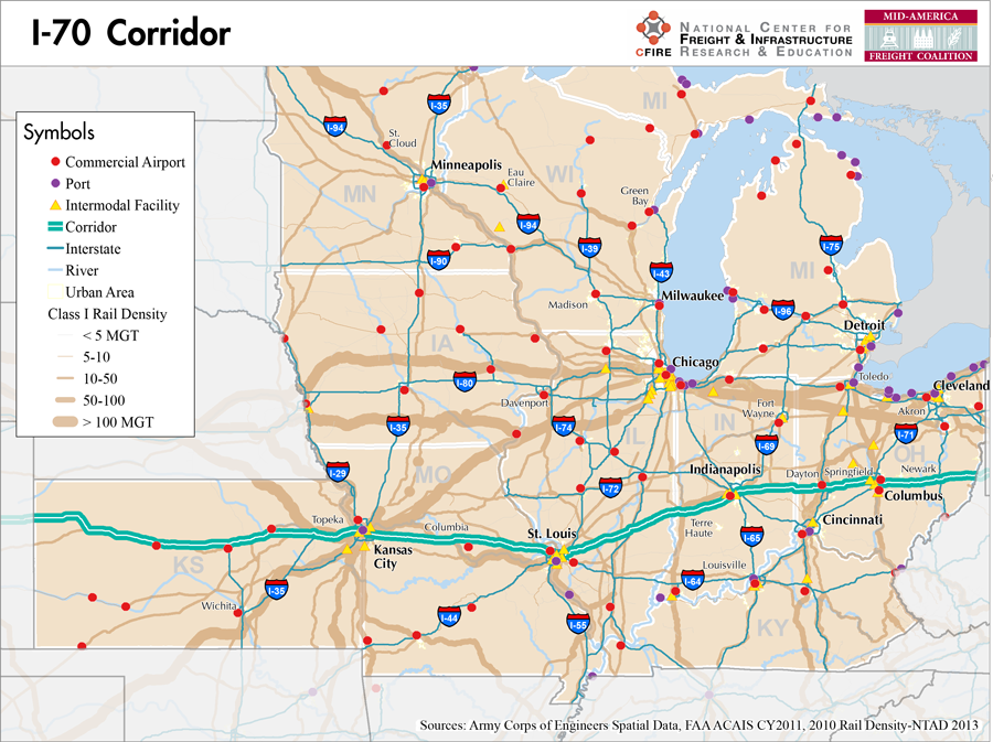
I-70 is a major east-west freight corridor in the MAFC region. Nationally, I-70 begins at the junction of I-15 in Utah, travels through Colorado, then through the MAFC states of Kansas, Missouri, Illinois, Indiana, and Ohio. Exiting Ohio, I-70 continues through West Virginia, Pennsylvania, and Maryland. In Kansas and Missouri, I-70 is nicknamed the “main street” as it crosses these two states in its entirety and passes through most of the major communities. I-70 was identified as one of the Corridors of the Future and the four states of Missouri, Illinois, Indiana, and Ohio worked together to complete a corridor level improvement assessment, and then a feasibility study of truck-only lanes. The truck-only approach was a new option and generated quite a bit of interest across the nation. While the Improve I-70 study has been completed and a variety of capacity and safety options have been evaluated, there is currently no funding to rebuild or widen I-70 as a corridor level project.
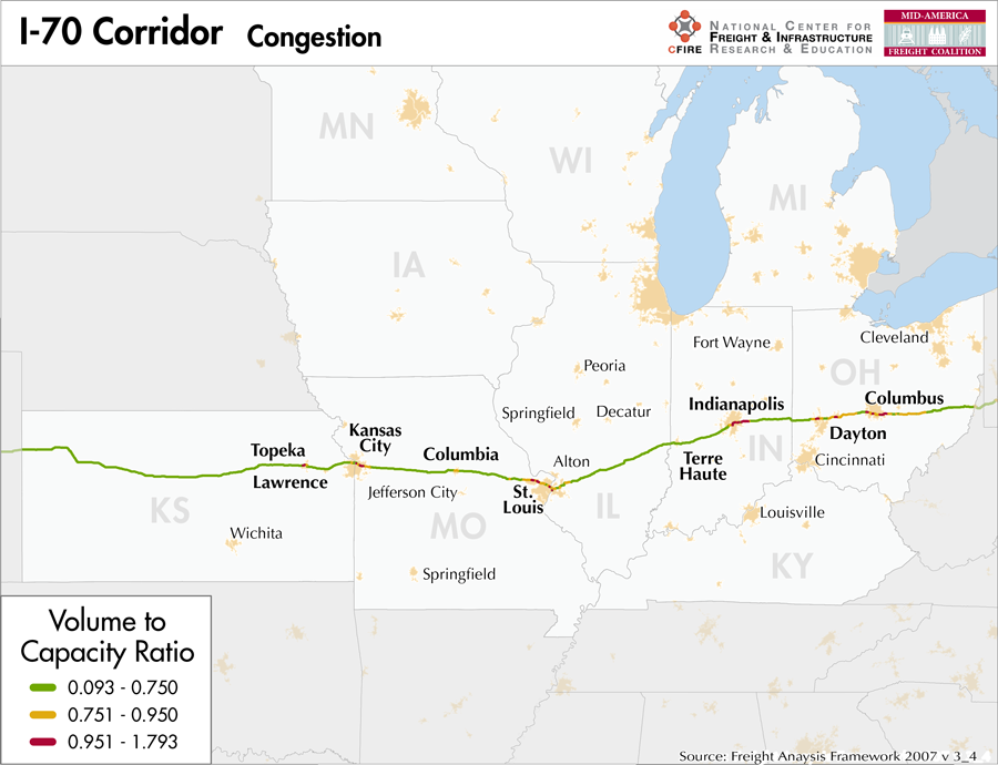
This corridor qualifies as a Tier 1 corridor on the MAFC nationally significant corridor network from Kansas City, MO to the Ohio–West Virginia border. With higher truck volumes, national connectivity, and links to numerous ports and intermodal locations, I-70 is a nationally significant corridor. In Kansas, truck volumes decrease and the corridor is classified as an emerging corridor. Given the length of I-70 across these five MAFC states, the corridor serves rural recreational and agriculture needs, commuting patterns, long distance and regional freight movements, manufacturing, and urban development.
In Kansas, I-70 is a tolled facility from near Bonner Springs, Kansas west to Topeka (1). The remaining portions of the facility in the MAFC region are not tolled. An additional tolled portion of I-70 exists in Pennsylvania. In Kansas, bridge restriction and vertical clearance maps are available for major freight corridors (2). In Missouri, I-70 is is a designated truck route (3). In Illinois, I-70 is listed on the designated truck route list and in Indiana I-70 is both a statewide mobility corridor and a high priority and commerce corridor. In Ohio, the corridor is part of the macro corridor highway system designed to move the largest volumes of people and freight.
Parallel rail service exists along most of all of I-70 across the MAFC region except for portions of the route in eastern Ohio. Parallel marine service is available from Kansas City to St. Louis on the Missouri River and then the Mississippi River to the Ohio and then the Ohio to Cincinnati, Huntington and points east along the Ohio River. This marine route that parallels I-70 on the Missouri, Mississippi, and Oho Rivers has been designated as Marine Highway 70 Corridor (M-70) by the Maritime Administration. Ohio DOT is the lead state for M-70 and meetings in both Missouri and Ohio have taken steps to promote and implement this marine highway.
The communities and metro areas that I-70 services in Kansas include: Colby, Hayes, Salina, Junction City, Manhattan, Topeka, Lawrence, and Kansas City, Kansas. In Missouri, I-70 serves the communities of Kansas City, Blue Springs, Odessa, Columbia, Warrenton, and St. Louis. In Illinois I-70 provides service to East St. Louis, Collinsville, Vandalia, and Effingham. Then I-70 continues through Terre Haute, Indianapolis and Richmond, Indiana before entering Ohio. In Ohio, I-70 serves Dayton, Springfield, Columbus, Zanesville, and Cambridge before exiting the state into Wheeling, WV.
Metropolitan Statistical Areas Economic Profile
| MSA | Population | GDP (2011, in millions) | Employment | Freight-related Employment | Metropolitan Planning Organizations |
| Manhattan (KS) | 92,719 | $6,505 | 61,753 | 15,913 | Flint Hills MPO |
| Topeka (KS) | 233,870 | $9,500 | 118,514 | 33,301 | Metropolitan Topeka Planning Organization |
| Lawrence (KS) | 110,826 | $3,568 | 49,764 | 17,779 | Lawrence-Douglas County Metropolitan Planning Office |
| Kansas City (MO-KS) | 2,009,342 | $108,144 | 1,036,081 | 398,896 | Mid-America Regional Council |
| Columbia (MO) | 162,642 | $6,917 | 103,932 | 26,598 | Columbia Area Transportation Study Organization |
| Jefferson City (MO) | 149,807 | $5,907 | 82,060 | 24,020 | Capital Area MPO |
| St. Louis (MO-IL) | 2,787,701 | $132,029 | 1,338,018 | 502,178 | East-West Gateway Council of Governments |
| Terre Haute (IN) | 172,425 | $5,817 | 72,202 | 31,408 | West Central Indiana Economic Development District |
| Indianapolis (IN) | 1,887,877 | $103,815 | 925,961 | 323,431 | Indianapolis MPO |
| Dayton (OH) | 799,232 | $33,915 | 414,916 | 159,460 | Miami Valley Regional Planning Commission |
| Springfield (OH) | 138,333 | $3,549 | 61,466 | 22,031 | Clark County-Springfield Transportation Coordinating Committee |
| Columbus (OH) | 1,901,974 | $93,986 | 994,759 | 344,671 | Mid-Ohio Regional Planning Commission |
| Wheeling (WV-OH) | 147,950 | $5,753 | 70,414 | 24,519 | Bel-O-Mar Regional Council and Interstate Planning Commission |
National Connectors
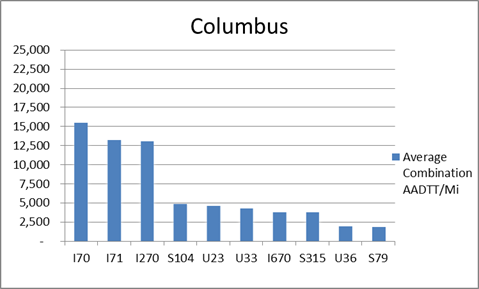
Columbus
The interstates supporting freight originating in, destined for, and traveling through Columbus include I-70 and I-71. In total, Columbus has 17 urban interstates, freeways, and expressways that support freight movements. I-70 and I-71 are first and second respectively based on of the average combination AADTT per mile. Furthermore, I-70 and I-71 transport 65.3 percent of combination truck miles on urban interstates, freeways, and expressways in Columbus.
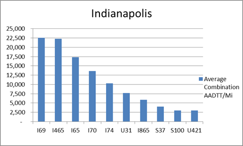
Indianapolis
The interstates supporting freight originating in, destined for, and traveling through Indianapolis include I-74, I-70, I-65, I-70, and I-69. In total, Indianapolis has 12 urban interstates, freeways, and expressways that support freight movements. I-69, I-65, and I-70 rank first, third, and fourth respectively based on the average combination AADTT per mile. Furthermore, I-69, I-65, and I-70 transport 58.5 percent of combination truck miles on urban interstates, freeways, and expressways within Indianapolis.
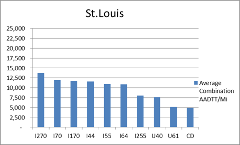
St. Louis
The interstates supporting freight originating in, destined for, and traveling through St. Louis include I-44, I-55, I-64, and I-70. In total, St. Louis has a total of 35 urban interstates, freeways, and expressways that support freight movements. I-70 and its national connectors I-270 and I-170 are the top three freight-carrying roadways ranked by average combination AADTT per mile. In total I-70, I-170, and I-270 carry 36.4 percent of truck miles traveled on urban interstates, freeways, and expressways within St. Louis.
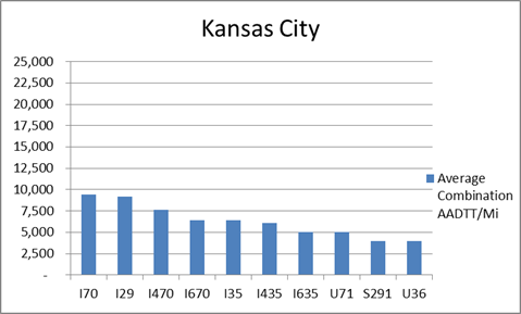
Kansas City
The interstates supporting freight originating in, destined for, and traveling through Kansas City include I-29, I-35, I-49B, and I-70. In total, Kansas City has 30 urban interstates, freeways, and expressways that support freight movements. I-70 and its national connectors I-470 and I-670 are three out of the top four roadways ranked by average combination AADTT per mile. In total I-70, I-470, and I-670 carry 26.7 percent of truck miles traveled on urban interstates, freeways, and expressways within Kansas City.
Freight Projects Impacting Truck Traffic
I-70 is one of the interstate corridors that is receiving the most improvements and upgrades to its freight capacity.
- As part of its designation as a Corridor of the Future, I-70 was the subject of a four-state dedicated truck lane (DTL) study. The DTL study was a collaboration between Missouri, Illinois, Indiana, and Ohio to explore innovative solutions to increased future traffic with a heavy emphasis on freight. The I-70 corridor is critically important to the economy of study states shown by 50 percent of corridor traffic moving within and between Missouri, Illinois, Indiana, and Ohio.
- In Missouri, through its ImproveI70 project, the state DOT has determined that I-70 requires major improvements to meet the needs of both passengers and freight, but has yet to find funding for the upgrades. At a minimum, the state would like to widen the interstate to six lanes from Kansas City to St. Louis.
- At the Missouri and Illinois border in St. Louis, the two states are collaborating to build the New Mississippi River Bridge. By relocating one interstate (I-70) from the Poplar Street Bridge (PSB) to the New Mississippi River Bridge, congestion will decrease at this bottleneck and safety will increase. PSB is currently the only major river crossing, carrying I-70, I-64 and I-55.
- In Indiana a major project is being undertaken to increase safety and accommodate large freight carriers. The I-65/I-70 South Split project in Indianapolis will close I-65 and I-70 on the east side of Indianapolis for approximately 59 days in order to lower pavement under seven bridges to allow clearances sufficient for oversize/overweight freight.
- Farther west, the Heartland Corridor project completed its Central Corridor upgrades in 2011. The Class I rail corridor runs from the Port of Hampton Roads, VA to Chicago. The project was a three-year effort to raise tunnel clearances and other obstructions on the Norfolk Southern route to accommodate double-stack intermodal rail traffic from the east coast to Chicago. The Heartland Corridor terminates at the new Rickenbacker Intermodal Terminal near I-70 in Columbus. The project was a public-private collaboration between the federal government, the states of Virginia, West Virginia, and Ohio and Norfolk Southern.
Truck Traffic
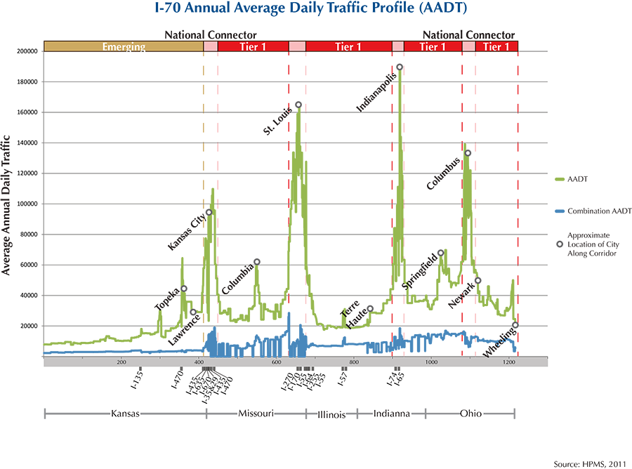
I-70 is a 1,216-mile corridor that crosses five states in the MAFC: Ohio, Indiana, Illinois, Missouri, and Kansas.
- VMT 2007: 42,175,024
- Truck VMT 2007: 11,759,747
- Percent Truck VMT: 27.9 percent
Operational Efficiency (ITS)
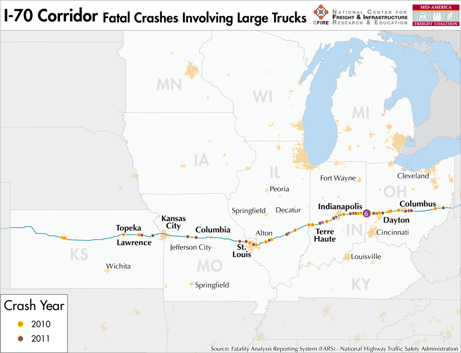
Both cameras (181) and message boards (92) are found throughout the I-70 corridor, except in the state of Illinois, where both are absent. In the majority of MAFC states transected by I-70, message boards and cameras are clustered around urban areas such as Kansas City (12/54), St. Louis (44/46), Indianapolis (9/39), and Columbus (6/16). However, in Kansas, both message boards and cameras are found at regular intervals despite the infrequency of urban areas along that portion of I-70.
Illinois, Indiana, and Ohio collaborate with Kentucky through ITS Heartland, whereas Missouri and Kansas work with Iowa, Nebraska, and Oklahoma as part of ITS Midwest. Additionally, the Illinois and Kansas DOTs participate in the ENTERPRISE Pool Fund Study.
Greenhouse Gas Emissions
- Yearly tons of CO2 assuming 4 mpg: 8,400,000
- Yearly tons of CO2 assuming 7.5 mpg: 4,500,000
Methodology
- Data: Truck Counts (HPMS 2011)
- Assume 4 and 7.5 miles per gallon
- No control for level of service or elevation changes
- 22.3 lbs. of CO2 per gallon of Diesel
Fuel and Truck Parking
| There are 89 fueling stops that also offer truck parking along I-70. Ten truck stops have less than 25 parking stops, 34 have between 25-84 spots, and 45 have 85+ spots of parking capacity. Compressed Natural Gas (CNG) and Liquified Natural Gas (LNG) stations are listed to the right. | I-70 | CNG | LNG |
| Public | 6 | 0 | |
| Private | 7 | 0 | |
| Planned | 3 | 2 | |
| Total | 16 | 2 |
Infrastructure Condition
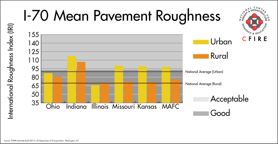
The International Roughness Index (IRI) measures the cumulative amount of vertical deviation (the bumpiness or roughness) for each segment of road, and is reported as a ratio in inches per mile. IRI values less than 95 are generally considered good, while values between 95 and 170 are generally considered acceptable. Since only corridor segments with reported IRI values from the 2011 HPMS dataset were considered in this analysis, some states may be missing from certain corridors.
The IRI is used as a measurement to determine infrastructure conditions within the Highway Performance Monitoring System (HPMS) such as pavement deterioration, pavement condition trends, cost allocation studies, and other analytical purposes. It is reported, at a minimum, for all road segments that fall under the Full Extent classification which includes the National Highway System (NHS), all principal arterials (interstates, freeways, and expressways), and rural minor arterials within the Sample Panel dataset. The data is collected by the states and submitted to the FHWA. The FHWA verifies the data, and houses it within the HPMS. For more historical information, see MnDOT’s Introduction to the International Roughness Index.
Freight Facilities
Intermodal Terminals
Columbus
- Norfolk Southern – Rickenbacker Columbus, OH: TOFC-COFC
- Norfolk Southern Buckeye: TOFC-COFC (>130,000 lifts/yr.)
Indianapolis
- Indiana Railroad (INRD) Indianapolis
St. Louis
- CSX Rose Lake Yard East St. Louis: TOFC-COFC (>60,000 lifts/yr.)
- Norfolk Southern Luther Yard St. Louis: TOFC-COFC (>80,000 lifts/yr.)
Kansas City
- Union Pacific (UP) Neff Yard: TOFC-COFC
- BNSF Argentine: TOFC-COFC-RR (>250,000 lifts/yr.)
Major Rail Yards
- 23rd Street Yard
- Avon Yard
- Argentine Yard
- Armourdale
- Armstrong
- Avondale
- Knoche
- Neff Yard
- Parsons
- Rose Lake
- Salina
- Topeka
- Tower Grove
- Venice
Airports
- Indianapolis International (IND)
- Rickenbacker International (LCK)
- Kansas City International (MCI)
- Lambert-St. Louis International (STL)
- James M Cox Dayton International (DAY)
Ports
- Port of Kansas City
- Port of St. Louis
- Port of Louisville
- Port of Indiana – Jeffersonville
- Port of Cincinnati
Automotive Distribution Centers
- Kansas City Vehicle Facility (BNSF)
- GM Fairfax – UP
- Muncie, KS – UP
- Wentzville, MO-NS
Freight Rail
The I-70 corridor has parallel freight rail service by all the Class I railroads.
In Ohio, the Norfolk Southern (NS), as well as a number of shortlines, operate from Columbus to Dayton. The CSX operates from Terre Haute, IN to St. Louis, MO. Norfolk Southern provides freight service from St. Louis west to New Florence, MO.
Also in Missouri, the predominate route running west from Mayview to Kansas City is the Kansas City Southern, operating a light density line with less than five million gross tons (MGT) according to 2010 rail density data from the 2013 National Transportation Atlas Database. From Woolridge to Nelson the UP River Subdivision carries between 50-100 MGT. In Kansas, practically the entire corridor offers freight service.
In Topeka, the UP Kansas Subdivision, carries over 100 MGT for 8 miles. Other heavy segments (over 100 MGT) occur over the Union Pacific Kansas Subdivison, and the Scott, Emporia, and St. Joseph Subdivisions over BNSF in Kansas City.
Emerging Intermodal
CSX invested $175 million in 2011 to clear bottlenecks at distribution points in Maryland, North Carolina Ohio, Pennsylvania, Virginia,and West Virginia. This project, called the National Gateway, will allow for double stack trains between mid-Atlantic ports and the Midwest. An enlarged Buckeye Yard in Columbus and the new North Baltimore Intermodal Facility were part of the $850 million public-private partnership.
In Kansas City, the operations at Argentine Yard will be transferred to the new BNSF Logistics Park slated to open Fall 2013. The facility is located outside the 1-70 corridor in Edgerton, KS. It will have a lift capacity of 2 million containers a year.
New intermodal service via Canadian National (CN) to/from Indianapolis to/from Chicago will reduce backhauls to Chicago terminals.
Passenger Rail
Within the I-70 corridor there is little trackage falling inside the corridor. Various passenger services have stops along the corridor in the following cities: Indianapolis, In; Effingham, IL; St. Louis Mo. , Independence, MO; Kansas City, MO; Lawrence Kansas, Topeka Kansas. Missouri River Runner parallels I-70 outside of the six-mile buffer zone.
Airports
There are five air cargo airports along the I-70 Corridor.
IND in Indianapolis is the second ranked airport in the MAFC region and fifth nationally in terms of landed weight in 2012. LCK in Columbus, MCI in Kansas City, STL in St. Louis, and DAY in Dayton rank 7th, 11th, 14th, and 26th respectively in the MAFC region while ranking 33rd, 50th, 61st, and 118th nationally. UPS and FedEx Express both have air cargo facilities at each of the airports on the I-70 corridor.
| Indianapolis International (IND) | Rickenbacker International (LCK) | Kansas City International (MCI) | Lambert-St Louis International (STL) | James M Cox Dayton International (DAY) | |
| Cargo Facilities | Bonded Warehouse, Free Port/Foreign Trade Zone, Aircraft Maintenance, Express/Courier Centre | Bonded Warehouse, Free Port/Foreign Trade Zone, Aircraft Maintenance, Dangerous Goods, Very Large/Heavy Cargo; Cargo Handling Agents:Evergreen/EAGLE | Warehouse 30 000m² (322 917sq ft), Bonded Warehouse, Transit Zone, Free Port/Foreign Trade Zone, Aircraft Maintenance, Mechanical Handling, Heated Storage, Air-Conditioned Storage, Refrigerated Storage, Animal Quarantine, Fresh Meat Inspection, Health Officials, X-Ray Equipment, Security for Valuables, Dangerous Goods, Radioactive Goods, Very Large/Heavy Cargo, Express/Courier Centre, Handling Equipment: Airport owned CAS Wide-body Main Deck Loader for lezse per use | Capacity 4 479 700tonnes (9 875 946,000lbs), 2x 747 Freighter Docks, Bonded Warehouse, Free Port/Foreign Trade Zone, Aircraft Maintenance, Mechanical Handling, Heated Storage, Air-Conditioned Storage, Refrigerated Storage, X-Ray Equipment, Security for Valuables, Dangerous Goods, Radioactive Goods, Very Large/Heavy Cargo, Express/Courier Centre, New cargo facility development by Aeroterm of 22854 sq metres also available | Warehouse 18 600m² (200 208sq ft), 78x 747 Freighter Docks, Bonded Warehouse, Free Port/Foreign Trade Zone, Aircraft Maintenance, Mechanical Handling, Heated Storage, Air-Conditioned Storage, Deep Freeze Storage, Livestock Handling, Health Officials, X-Ray Equipment, Security for Valuables, Fumigation Equipment, Dangerous Goods, Radioactive Goods, Very Large/Heavy Cargo, Express/Courier Centre |
| Cargo Terminals | 4 | 5 | 2 | 1 | |
| Number of Runways (max. length) | 3 (11,200 feet) | 2 (12,103 feet) | 3 (10,800 feet) | 4 (11,020 feet) | 3 (10,902 feet) |
| Warehouses & DCs within 5/10 miles | 16 / 34 | 6 / 29 | 1 / 2 | 15 / 41 | 8 / 21 |
| Air Cargo Businesses within Urban Area | 533 | 459 | 626 | 845 | 437 |
| 2011 Landed Weight (lbs.) | 4,813,314,835 | 653,902,306 | 423,890,310 | 384,332,870 | 43,372,800 |
| 2010 Landed Weight (lbs.) | 4,717,295,655 | 683,430,047 | 431,918,705 | 371,026,650 | 43,166,000 |
| Change (Percentage) | 2.04% | -4.32% | -1.86% | 3.59% | 0.48% |
| Intermodal Connectors (5/10 miles) | 8 / 9 | 3 / 3 | 4 / 4 | 2 / 7 | 4 / 7 |
Ports
M-70 is the designated Marine Highway reliever route for I-70 between Kansas City, MO and Pittsburgh, PA. The western segment of the M-70 consists of the Missouri River, which requires no navigation locks. The eastern segment of M-70 consists of the Ohio River and the Mississippi River between the mouths of the Missouri and Ohio Rivers, and is equipped with 1,200 foot locks. Major ports along the route include Kansas City, MO; St. Louis, MO; Mt. Vernon, IN; Louisville, KY; Cincinnati, OH; Huntington Tri-State; and Pittsburgh, PA. There are numerous smaller ports and terminals along M-70 that potentially provide additional access between the Interstate and the rivers. M-70 is the major east-west axis of the inland Marine Highway System and connects directly to other major inland Marine Highways (M-55, M-65, M-94).

Freight Generators, Warehouses, and Distribution Centers
There are a total of 42,425 freight generators employing 723,809 people within three miles of the I-70 corridor, and a total of 87,958 freight generators employing 1,468,325 people within 10 miles of the corridor. If the extent of analysis focuses on the metropolitan statistical areas (MSAs) intersected by the I-70 corridor, there are a total of 118,947 freight generators employing 1,924,205 people. Within the MSAs, there are a total of 573 warehousing and distribution centers employing 21,370 people. Freight generators were determined by using the NAICS codes prescribed for freight-related sectors in NCFRP Report 19, and include agriculture, mining, manufacturing, wholesale trade, retail trade, transportation and warehousing, and eating and drinking places.
| Major Manufacturers | Major Distribution Centers |
|
|
References
- Interstate 70. Wikipedia.
- Bridge Restrictions Map. Kansas Department of Transportation.
- Missouri Vehicle Route Map: 2012-2013. Missouri Department of Transportation.
- FHWA Interstate Brief (2011). US Department of Transportation.