DRAFT
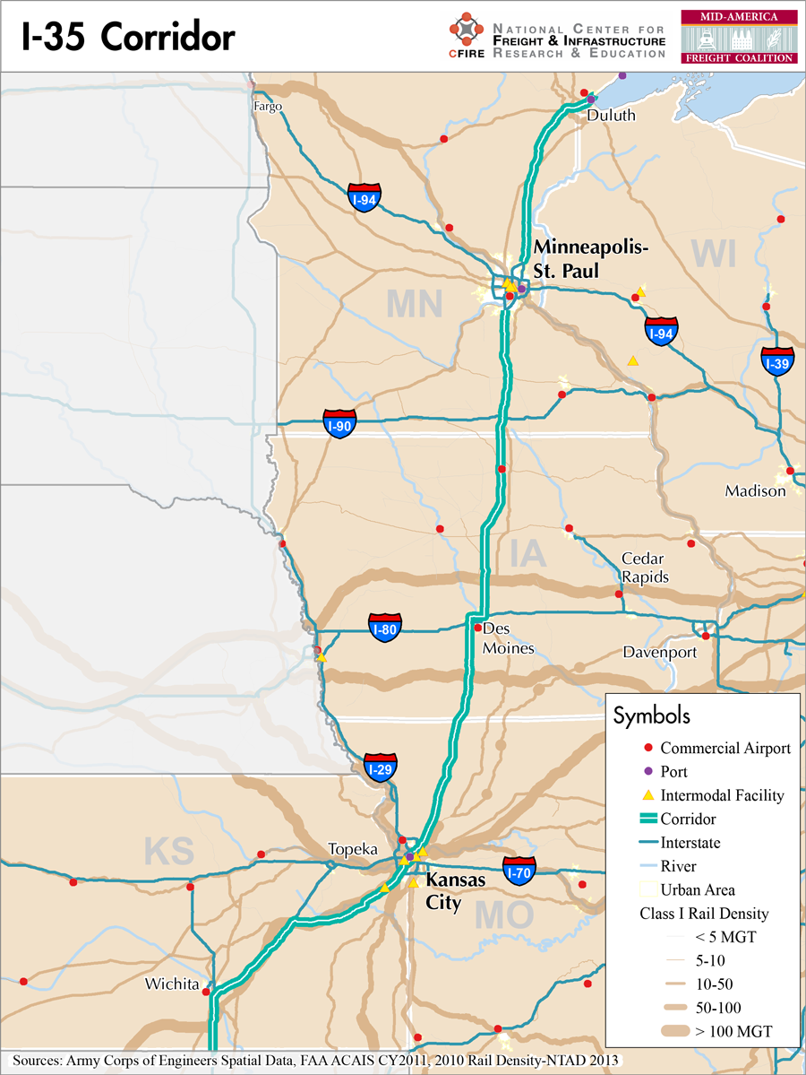
Kansas Border to Duluth, Minnesota
Snapshot: Length: 1,568 miles | Length in MAFC: 870 miles | Intersecting Interstates: I-10, I-40, I-70, I-80, I-90
Interstate 35 in a major north-south corridor in the MAFC that begins at the Kansas border south of Wichita and travels through Kansas, Missouri, Iowa, and Minnesota. Interstate 35 is a border to border corridor. The full length of I-35 crosses six states. Outside of the MAFC region, I-35 begins in Laredo, Texas and crosses Oklahoma before entering Kansas and then terminates in Duluth, Minnesota (1).
With its border to border connection, I-35 has been part of the NAFTA super-corridor proposal in Texas and would have consisted of 1,200 foot wide corridors that would contain all utilities and transport systems and be designed to facilitate trade. Ultimately, the border-to-border connection provided by I-35 was associated with the vision of a free-trade block consisting of the United States, Canada, and Mexico. This Trans-Texas approach to I-35 was repealed in Texas in 2011 due to political conflict concerning the benefits of open and fair trade among the three countries. While the Trans-Texas approach was dismissed, the importance of this corridor as a border-to-border system that can be leveraged by MAFC states is increasingly relevant for the development of business and industry in the Coalition states. The NAFTA concept is still very much alive and with Canada and Mexico as the two top trading partners for MAFC states. These connections continue to be important.
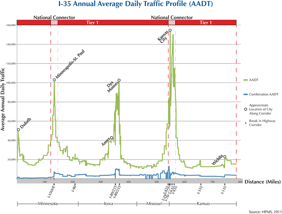
Interstate 35 is categorized as a Tier 1 corridor that meets MAP-21 primary Freight Network Criteria based on the border connections. It has been defined as a high priority corridor by Congress (2). Through Kansas, I-35 runs parallel to rail facilities and in Missouri separates only slightly from north-south rail facilities. In Iowa, I-35 has a Class 1 rail offset but parallel to the corridor. In Minnesota, I-35 is closely paralleled by rail facilities. In Minnesota I-35 is listed as a super-load corridor and a part of the Twin Trailer network (3). In all states I-35 is listed as a national truck corridor.
There are numerous reconstruction and resurfacing projects on I-35. In Minnesota there are 16 scheduled repairs from bridge deck replacement to resurfacing. In Iowa there are six projects listed in 2013, from widening to resurfacing. In Missouri, there are also a series of urban projects through the Kansas City area that are expected to cause considerable delay and inconvenience (4). In Kansas the recent SW Johnson County interchange is very relevant to freight movement (5). With the opening of the BNSF Intermodal and Logistics Park, Kansas is expecting more than 17,000 vehicle trips per day of which 7,000 will be commercial vehicles generated by the BNSF facility.
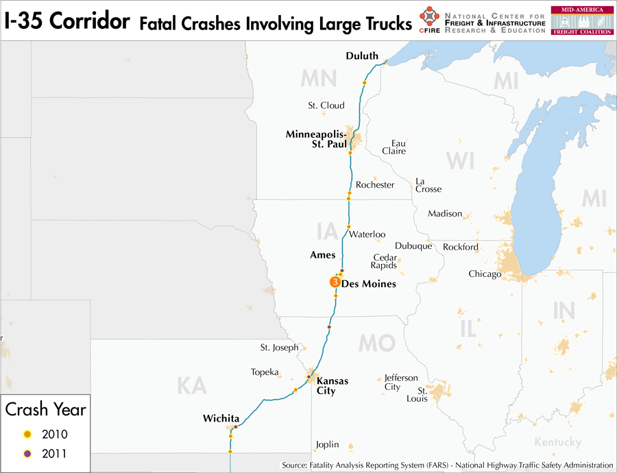
In the MAFC region, I-35 serves the major metropolitan areas of Wichita, and then passes Edgerton near the new BNSF facility, then on to Kansas City, Kansas and Missouri. Through most of Kansas I-35 is part of the Kansas Turnpike Authority and is tolled. After passing Emporia, Kansas, I-35 heads more easterly towards Kansas City and is no longer a tolled facility. After passing through Kansas City and northern Missouri, I-35 enters Iowa and passes through Des Moines, Ames, and Mason City, and on to Albert Lea, Minnesota. Interstate 35 continues north through Owatonna, Faribault and the Minneapolis/St. Paul area and on to its terminus at Duluth, Minnesota. The larger metropolitan statistical areas along the corridor include Wichita, Kansas City, Kansas and Missouri, Des Moines and Ames, Iowa as well as Minneapolis/St Paul and Duluth, Minnesota.
Metropolitan Statistical Areas Economic Profile
| MSA | Population | GDP (2011, in millions) | Employment | Freight-related Employment | Metropolitan Planning Organizations |
| Duluth (MN-WI) | 279,771 | $10,027 | 158,705 | 52,906 | Metropolitan Interstate Council |
| Minneapolis-St. Paul (MN) | 3,348,859 | $207,819 | 1,879,085 | 716,724 | Twin Cities Metropolitan Council |
| Des Moines (IA) | 569,633 | $40,691 | 343,356 | 102,626 | Des Moines Area MPO |
| Ames (IA) | 89,542 | $4,243 | 43,630 | 15,703 | Ames Area MPO |
| St. Joseph (KS-MO) | 127,329 | $4,679 | 67,449 | 30,770 | St. Joseph Area Transportation Study Organization |
| Kansas City (MO-KS) | 2,009,342 | $108,144 | 1,036,081 | 398,896 | Mid-America Regional Council |
| Topeka (KS) | 233,870 | $9,500 | 118,514 | 33,301 | Metropolitan Topeka Planning Organization |
| Wichita (KS) | 630,919 | $27,363 | 311,377 | 143,048 | Wichita Area MPO |
National Connectors
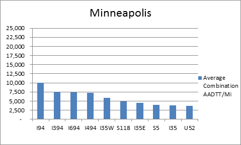
Minneapolis
The interstates that support freight originating in, destined for, and traveling through Minneapolis include I-35 and I-94. In total, Minneapolis has 32 urban interstates, freeways, and expressways that support freight movements. I-94 and its national connectors I-394, I-494, and I-694 are the top four roadways ranked by average combination AADTT per mile. In total I-94, I-394, I-494, and I-694 carry 52.4 percent of truck miles traveled on urban interstates, freeways, and expressways within Minneapolis.
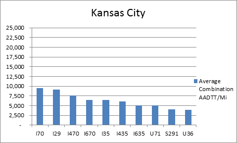
Kansas City
The interstates that support freight originating in, destined for, and traveling through Kansas City include I-29, I-35, I-49B, and I-70. In total, Kansas City has 30 urban interstates, freeways, and expressways that support freight movements. I-70 and its national connectors I-470 and I-670 are three out of the top four roadways ranked by the average combination AADTT per mile. In total I-70, I-470, and I-670 carry 26.7 percent of truck miles traveled on urban interstates, freeways, and expressways within Kansas City.
Freight Projects Impacting Truck Traffic
Several recent projects on I-35 will increase the efficiency of freight movement in the corridor and help to handle growing traffic volumes from local industry.
- In Missouri, there are a series of urban projects through the Kansas City area that are expected to cause considerable delay and inconvenience. Missouri also completed major reconstruction of a segment of I-29/I-35 in northern Kansas City including a new bridge crossing the Missouri River.
- In Kansas, freight movement is a major beneficiary of the SW Johnson County interchange project. With the opening of the BNSF Intermodal and Logistics Park, Kansas is expecting more than 17,000 vehicle trips per day, of which 7,000 will be commercial vehicles generated by the BNSF facility.
- In Iowa, the Iowa Northern Railway Company is expanding on more than 350 acres in northern Iowa. This intermodal logistics hub is located near three Interstates and three Class 1 rail lines.
Truck Traffic
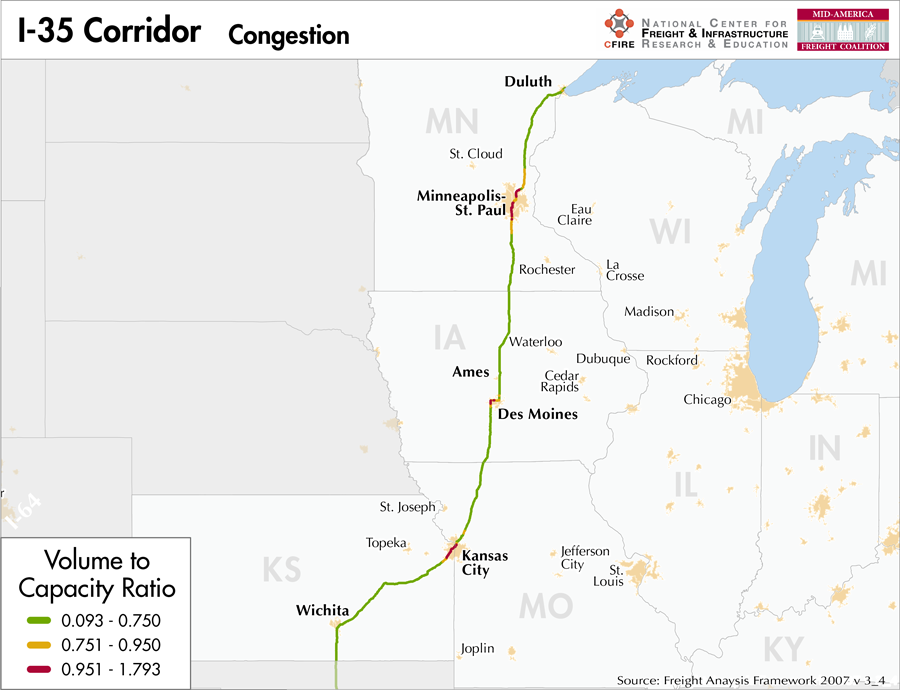
I-35 is an 870-mile corridor that crosses four states in the MAFC: Minnesota, Iowa, Missouri, and Kansas.
- VMT 2007: 23,250,223
- Truck VMT 2007: 4,179,497
- Percent Truck VMT: 18.0 percent
Operational Efficiency (ITS)
The majority of cameras (61) on I-35 are located within the reaches of Kansas City’s urban boundaries, with the remaining 10 cameras found within 20 miles of the southern extent of the metropolitan area. Although found in each of the three MAFC states that are bisected the I-35 corridor, message boards are also concentrated in urban areas, the vast majority of which are found in Minneapolis-St Paul (203). However, smaller clusters are found in Des Moines (12) and Kansas City (13).
Minnesota has an individual membership to ITS America, whereas Iowa and Missouri collaborate with Kansas, Nebraska, and Oklahoma through ITS Heartland. The Minnesota, Iowa, and Kansas DOTs participate in the ENTERPRISE Pool Fund Study.
Greenhouse Gas Emissions
- Yearly tons of CO2 assuming 4 mpg: 2,800,000
- Yearly tons of CO2 assuming 7.5 mpg: 1,500,000
Methodology
- Data: Truck Counts (HPMS 2011)
- Assume 4 and 7.5 miles per gallon
- No control for level of service or elevation changes
- 22.3 lbs. of CO2 per gallon of Diesel
Fuel and Truck Parking
| There are 49 fueling stops that also offer truck parking along I-35. Fifteen truck stops have less than 25 parking stops, 23 have between 25-84 spots, and 11 have 85 or more parking spots. Compressed Natural Gas (CNG) and Liquified Natural Gas (LNG) stations are listed to the right. | I-35 | CNG | LNG |
| Public | 5 | 0 | |
| Private | 2 | 0 | |
| Planned | 0 | 0 | |
| Total | 7 | 0 |
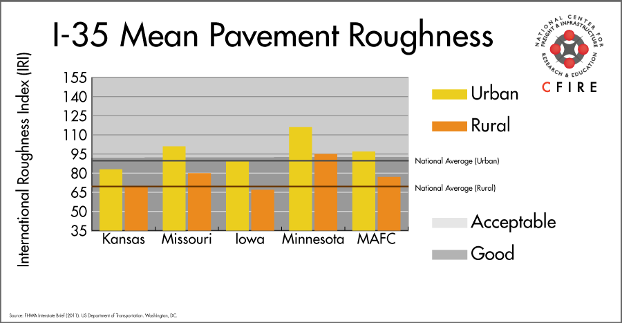
Infrastructure Condition
The International Roughness Index (IRI) measures the cumulative amount of vertical deviation (the bumpiness or roughness) for each segment of road, and is reported as a ratio in inches per mile. IRI values less than 95 are generally considered good, while values between 95 and 170 are generally considered acceptable. Since only corridor segments with reported IRI values from the 2011 HPMS dataset were considered in this analysis, some states may be missing from certain corridors.
The IRI is used as a measurement to determine infrastructure conditions within the Highway Performance Monitoring System (HPMS) such as pavement deterioration, pavement condition trends, cost allocation studies, and other analytical purposes. It is reported, at a minimum, for all road segments that fall under the Full Extent classification which includes the National Highway System (NHS), all principal arterials (interstates, freeways, and expressways), and rural minor arterials within the Sample Panel dataset. The data is collected by the states and submitted to the FHWA. The FHWA verifies the data, and houses it within the HPMS. For more historical information, see MnDOT’s Introduction to the International Roughness Index.
Freight Facilities
Intermodal terminals
Minneapolis
- Canadian National (CN) Intermodal Service from Minneapolis (via Chippewa Falls)
- Canadian Pacific (CPR) Intermodal Yard
- BNSF: Midway (Pierce Butler): TOFC-COFC
- Norfolk Southern (NS): RoadRailer
Kansas City
- Union Pacific (UP) Neff Yard: TOFC-COFC
- Burlington Northern Santa Fe (BNSF) Argentine Yard: TOFC-COFC-RoadRailer (>250,000 lifts/yr.)
- Norfolk Southern (NS) Voltz Yard: COFC- RoadRailer
Major Rail Yards
Minneapolis
- Shoreham
- Northtown
- St. Paul
Kansas City
- Northeast Industrial District in Kansas City includes Neff Yard (UP)
- Knoche Joint Agency Yard (It is now operated by the KCS and Iowa, Chicago and Eastern (IC&E)
- Argentine, Armstrong, Armoudale, Avondale, Murray
Emporia, KS
- Emporia Yard
Airports
- Wichita Mid-Continent (ICT)
- Kansas City International (MCI)
- Des Moines International (DSM)
- Minneapolis – St. Paul International (MSP)
Ports
- Port of Kansas City
- Port of Minneapolis/Port of St. Paul
- Port of Duluth / Port of Superior
Automotive Distribution Centers
- Dayton’s Bluff: St. Paul, MN (BNSF)
- Kansas City Vehicle Facility (BNSF)
- GM Fairfax (UP)
Freight Rail
There are good freight rail networks near the Port of Duluth, and the other urban areas which consist of Class I railroads and shortlines. The heaviest rail corridors (>100 million gross tons-MGT), from north to south, that intersect the I-35 corridor include: BNSF St. Paul Subdivision, UP Boone Subdivision, BNSF Ottumwa Subdivision, BNSF St. Joseph Subdivision, UP KC Metro, BNSF Fort Scott Subdivision, BNSF Emporia-A, and BNSF Panhandle. The BNSF Emporia-A runs parallel to I-35 from Kansas City through the state of Kansas.
Emerging Intermodal
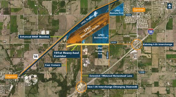
The BNSF will be opening an inland port in Edgerton Kansas, twenty miles outside of Kansas City in the fall of 2013. The 1,000-acre facility will have 440 acres devoted to an intermodal terminal with an initial capacity of 500,000 lifts. A supporting logistics network of warehouses and other distribution services is being developed on the remaining 560 acres. This facility will replace the Argentine Intermodal Facility (Kansas City), BNSF’s eighth busiest intermodal terminal. At full build-out the BNSF Edgerton Intermodal Terminal will have the capacity to process 1.5 to 2 million lifts per year. The entire project is called the Logistics Park Kansas City.
Iowa Northern Railway (IANR) in Manly, Iowa is developing the Upper Midwest Transportation Hub (UMT). Manly is the site of a significant interchange with Union Pacific and close to interchanges with Canadian National Railway (CN) and Canadian Pacific Railway (CPR). Manly is becoming a major storage and staging yard for frac sand originating in nearby states.
Passenger Rail
A short segment (13 miles) of the Southwest Chief route (Chicago to Los Angeles) runs parallel to I-35 in Kansas. Four routes intersect the I-35 corridor. Route description and stations are:
- Empire Builder (Chicago to Seattle), operates over Canadian Pacific (CP) trackage, station: Minneapolis
- California Zephyr (Chicago to San Francisco) operates over BNSF trackage, station: Osceola, IA
- Southwest Chief (Chicago to Los Angeles) operates over BNSF, station: Kansas City, MO
- Missouri River Runner (St. Louis to Kansas City, Mo) operates over Union Pacific (UP), station: Kansas City, MO
Iowa DOT in conjunction with Illinois DOT is conducting a study to determine environmental and service characteristics needed for a high-speed service from Chicago to Council Bluffs to Omaha, a segment of the Southwest Chief service.
Airports
There are four air cargo airports that service the I-35 corridor.
MSP in Minneapolis–St. Paul, DSM in Des Moines, MCI in Kansas City, and ICT in Wichita are ranked 5th, 10th, 11th, and 19th within the MAFC region respectively for landed weight in 2012. Nationally these airports are ranked 24th, 49th, 50th, and 87th. All four are considered primary hub airports, and all four airports are serviced by both UPS and FedEx air cargo facilities.
| Minneapolis-St Paul International (MSP) | Des Moines International (DSM) | Kansas City International (MCI) | Wichita Mid-Continent (ICT) | |
| Cargo Facilities | Capacity 210 000tonnes (462 966,000lbs), Free Port/Foreign Trade Zone, Mechanical Handling, Health Officials, Security for Valuables, Express/Courier Centre | Warehouse 30 000m² (322 917sq ft), Bonded Warehouse, Transit Zone, Free Port/Foreign Trade Zone, Aircraft Maintenance, Mechanical Handling, Heated Storage, Air-Conditioned Storage, Refrigerated Storage, Animal Quarantine, Fresh Meat Inspection, Health Officials, X-Ray Equipment, Security for Valuables, Dangerous Goods, Radioactive Goods, Very Large/Heavy Cargo, Express/Courier Centre, Handling Equipment: Airport owned CAS Wide-body Main Deck Loader for lease per use | ||
| Cargo Terminals | 1 | 2 | 5 | 4 |
| Number of Runways (max length) | 4 (11,007 feet) | 2 (9,002 feet) | 3 (10,800 feet) | 3 (10,301 feet) |
| Warehouses & DCs within 5 / 10 miles | 11 / 58 | 2 / 32 | 1 / 2 | 3 / 19 |
| Air Cargo Businesses within Urban Area | 1,303 | 133 | 626 | 275 |
| 2011 Landed Weight (lbs.) | 968,650,986 | 425,198,660 | 423,890,310 | 201,123,121 |
| 2010 Landed Weight (lbs.) | 1,024,128,613 | 434,435,240 | 431,918,705 | 199,534,048 |
| Change (Percentage) | -5.42% | -2.13% | -1.86% | 0.80% |
| Intermodal Connectors (5 / 10 miles) | 1 / 1 | 5 / 7 | 4 / 4 | 3 / 3 |
Ports
The proposed M-94 Marine Highway runs from the Upper Mississippi River between Minneapolis, MN and the mouth of the Illinois River and provides the nearest navigable waterway alternative to I-35. M-94 follows the eastern borders of Minnesota, Iowa, and Missouri. The river provides seasonal navigation through locks up to 600 feet in length and provides direct, uninterrupted water access to the rest of the Mississippi River System marine highway network, starting at M-55 at the junction of the Illinois and Mississippi rivers.
Freight shipped via I-35 between Minneapolis, MN and Kansas City, MO could be shipped via the M-94/M-55 and western M-70. Major river ports along this indirect route are located at Minneapolis, MN; St. Louis, MO; and Kansas City, MO. There are also numerous smaller ports providing additional access to the rivers.
Freight traveling on I-35 between Kansas City, MO and Mexico could be shipped via the M-70, M-55, and western Gulf inter-coastal waterway. The M-40 (McClellan-Kerr) waterway at Chatooska, OK provides another potential waterway connection between I-35 in central Oklahoma and M-55.


Freight Generators, Warehouses, and Distribution Centers
There are a total of 37,800 freight generators employing 713,048 people within three miles of the I-35 corridor, and a total of 65,469 freight generators employing 1,208,127 people within 10 miles of the corridor. If the extent of analysis focuses on the metropolitan statistical areas (MSAs) intersected by the I-35 corridor, there are a total of 86,998 freight generators employing 1,511,753 people. Within the MSAs, there are a total of 466 warehousing and distribution centers employing 11,474 people. Freight generators were determined by using the NAICS codes prescribed for freight-related sectors in NCFRP Report 19, and include agriculture, mining, manufacturing, wholesale trade, retail trade, transportation and warehousing, and eating and drinking places.
Major Manufacturers |
Major Distribution Centers |
|
|
References
- Interstate 35. Wikipedia.
- High Priority Corridors. Federal Highway Administration.
- Superload Corridors (2013). Minnesota Department of Transportation.
- Traffic Impact on 2013 Projects. Missouri Department of Transportation.
- I-35 SW Johnson County Interchange. Kansas Department of Transportation.
- FHWA Interstate Brief (2011). US Department of Transportation.