DRAFT
Western Iowa to Cleveland, Ohio
Snapshot: Length: 2,900 miles | Length in MAFC: 859 miles | Intersecting Interstates: I-5, I-15, I-25, I-35, I-55, I-65, I-75, I-81, I-90, I-95
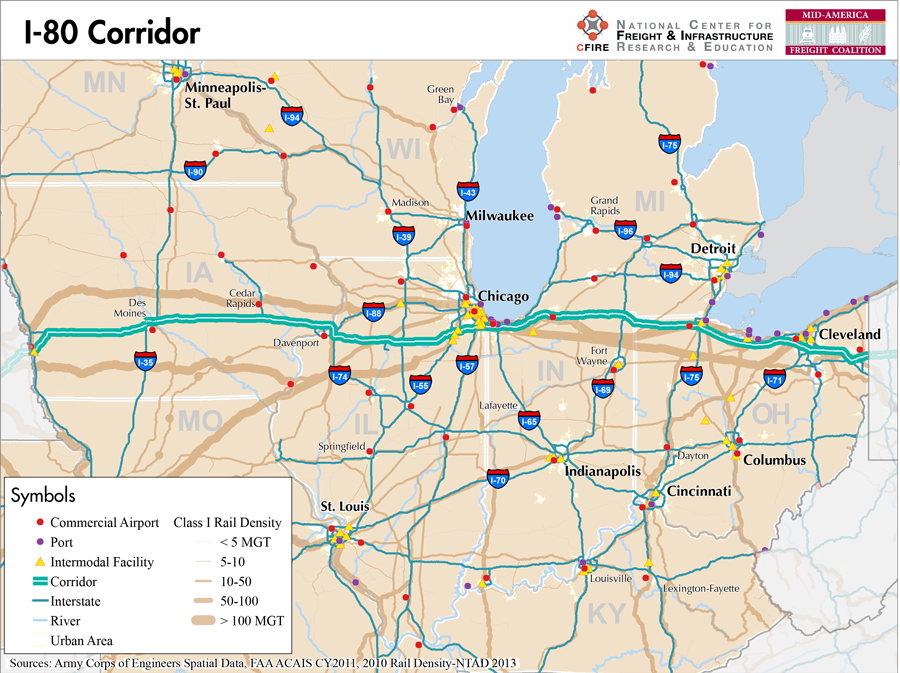
I-80 is the second longest interstate highway in the nation, stretching from downtown San Francisco to the New York City metropolitan area at Teaneck, New Jersey. Within the MAFC region, it crosses four states and carries a large volume of goods and people. It runs through central Iowa and the northern parts of Illinois, Indiana, and Ohio. Illinois and Indiana are collaborating on the Illiana Corridor that will help to relieve some congestion on I-80 in the southern part of the greater Chicago area by shifting traffic, especially freight, south of the denser parts of the city.
The MAFC regional freight study considers I-80 to be a Tier I freight corridor. Its transcontinental character contributes to this categorization as it is one of the few highways allowing freight to travel from one coast to the other on a single route. I-80 serves a number of different industries across the agricultural, manufacturing and trade sectors. It also services a significant number of major cities across the country. Within the MAFC, it is one of the main east-west routes along with I-70.
For a large portion of its extent across the MAFC states, I-80 is a toll road, starting from near Chicago, until Youngstown, Ohio. I-80 is the main portion of both the Indiana Toll Road and the Ohio Turnpike. For the majority of this route across Indiana and part of the distance in Ohio, I-80 also runs concurrent with I-90. Iowa identifies I-80 as a high volume truck route, while Illinois lists it as a designated truck route. Indiana also recognizes I-80 as a commerce corridor and Ohio includes it within the Access Ohio Strategic Transportation System.
There are a number of railroad routes which roughly follow the east-west path of I-80. The most direct route utilizes Norfolk Southern’s tracks from Cleveland west past Chicago and then the Iowa Interstate railroad past Des Moines. No waterways directly parallel I-80, although many of the cities have access to water ports on the Great Lakes or a number of river ways.
I-80 passes through numerous important cities along its route. Starting from the west these include Des Moines, Iowa City, the Quad Cities area, Lasalle-Peru, and Joliet in Iowa and Illinois. In Indiana, I-80 serves Gary, South Bend, and Elkhart before crossing into Ohio and passing through Toledo, Elyria, Strongsville, and Youngstown before it crosses into Pennsylvania.
Metropolitan Statistical Areas Economic Profile
| MSA | Population | GDP (2011, in millions) | Employment | Freight-related Employment | Metropolitan Planning Organizations |
| Omaha-Council Bluffs (IA-NE) | 865,350 | $48,979 | 506,335 | 186,374 | Omaha/Council Bluffs Metropolitan Area Planning Agency |
| Des Moines (IA) | 569,633 | $40,691 | 343,356 | 102,626 | Des Moines Area MPO |
| Iowa City (IA) | 152,586 | $7,902 | 76,164 | 26,182 | MPO of Johnson County |
| Quad Cities (IL-IA) | 379,690 | $18,311 | 195,502 | 84,353 | Bi-State Regional Commission |
| Chicago (IL) | 9,461,105 | $547,609 | 4,333,730 | 1,706,242 | Chicago Metropolitan Agency on Planning |
| Michigan City-La Porte (IN) | 111,467 | $3,671 | 49,115 | 21,084 | Northwestern Indiana Regional Planning Commission |
| South Bend-Mishawaka (IN-MI) | 319,224 | $12,782 | 148,445 | 59,443 | Michiana Area Council of Governments |
| Elkhart-Goshen (IN) | 197,559 | $9,111 | 122,847 | 76,397 | Michiana Area Council of Governments |
| Toledo (OH) | 610,001 | $28,037 | 341,253 | 137,872 | Toledo Metropolitan Area Council of Governments |
| Sandusky (OH) | 77,079 | $3,190 | 49,837 | 20,797 | Erie Regional Planning Commission |
| Cleveland (OH) | 2,077,240 | $106,810 | 1,095,636 | 427,398 | Northeast Ohio Areawide Coordinating Agency |
| Akron (OH) | 703,200 | $28,053 | 335,393 | 150,312 | Akron Metropolitan Area Transportation Study |
| Youngstown-Warren-Boardman (OH-PA) | 565,773 | $17,101 | 266,109 | 109,561 | Eastgate Regional Council of Governments |
National Connectors
Cleveland, OH
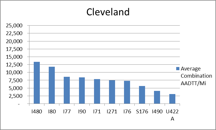
The interstates supporting freight originating in, destined for, and traveling through Cleveland include I-90, I-80, I-76, and I-71. In total, Cleveland has 21 urban interstates, freeways, and expressways that support freight movements. 33.1 percent of combination truck miles traveled on urban interstates, freeways, and expressways in Cleveland are on I-80 and I-480. Additionally, I-480 and I-80 are ranked first and second based on average combination AADTT per mile respectively.
Chicago, IL
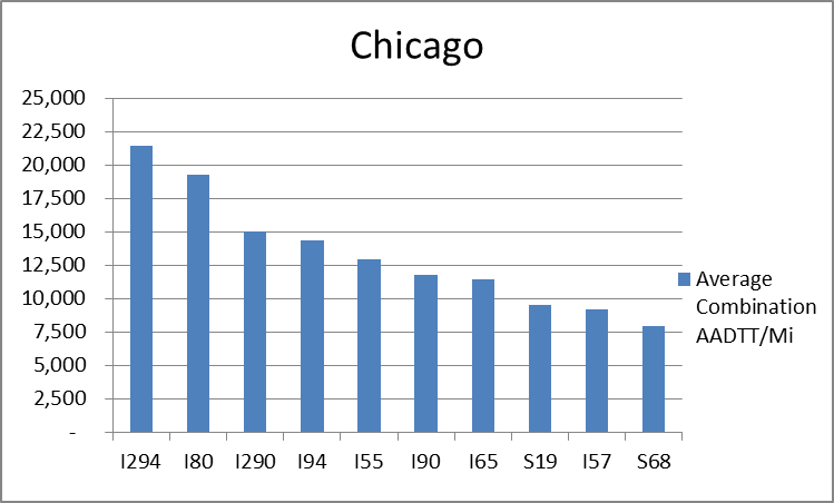
The interstates supporting freight originating in, destined for, and traveling through Chicago include I-55, I-57, I-88, I-89, I-90, and I-94. In total, Chicago has 42 urban interstates, freeways, and expressways that support freight movements. Chicago’s geographic location as a crossroad of numerous interstates causes a dispersion of freight throughout a large network of national connectors and interstates that travel through the city. The average combination AADTT per mile on Chicago’s urban interstates, freeways, and expressways is over 10,000 trucks for seven roadways and nearly 20,000 combination trucks for two roadways.
Freight Projects Impacting Truck Traffic
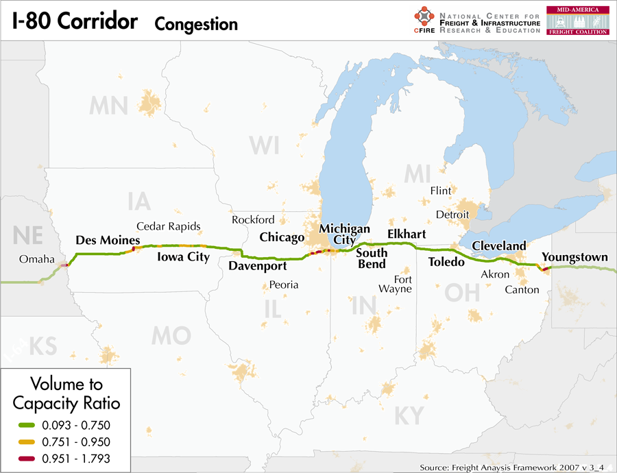
The proposed Illiana Corridor will reduce congestion on I-80 in the Chicago area by diverting truck and passenger traffic to the new corridor. The facility will also allow freight to avoid more congested urban areas, provide access to developing freight facilities and provide a base for job and economic development.
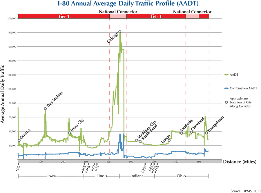
Truck Traffic
I-80 is an 859-mile corridor that crosses four states in the MAFC: Iowa, Illinois, Indiana, and Ohio.
- VMT 2007: 28,834,783
- Truck VMT 2007: 10,644,376
- Percent Truck VMT: 36.9 percent
Operational Efficiency (ITS)
The distribution of message boards (54) and cameras (20) along the I-80 corridor is highly variable. The majority (47) of message boards are located in Iowa, where they are distributed fairly evenly across the portion of I-80 bisecting the state. Elsewhere along the corridor, one message board is found to the east of Davenport and six more are located in the Indiana portion of the Chicago metropolitan area. This portion of Chicago is also where 16 of the 20 cameras on the I-80 corridor are located, with the remaining cameras found in Cleveland (2), Lorain-Elyria (1), and Toledo (1).
Iowa collaborates with Kansas, Missouri, Nebraska, and Oklahoma through IT Heartland, whereas Illinois, Indiana, and Ohio partner with Kentucky as part of IT Midwest. Additionally, the Iowa and Illinois DOTs participate in the ENTERPRISE Pool Fund Study.
Greenhouse Gas Emissions
- Yearly tons of CO2 assuming 4 mpg: 7,000,000
- Yearly tons of CO2 assuming 7.5 mpg: 3,700,000
Methodology
- Data: Truck Counts (HPMS 2011)
- Assume 4 and 7.5 miles per gallon
- No control for level of service or elevation changes
- 22.3 lbs. of CO2 per gallon of diesel
Fuel and Truck Parking
| There are 103 fueling stops that also offer truck parking along I-80. Twenty-five truck stops have less than 25 parking spots, 37 have between 25-84 spots, and 41 have 85+ parking spots. Compressed Natural Gas (CNG) and Liquified Natural Gas (LNG) stations are listed to the right. | I-80 | CNG | LNG |
| Public | 2 | 0 | |
| Private | 1 | 0 | |
| Planned | 1 | 4 | |
| Total | 4 | 4 |
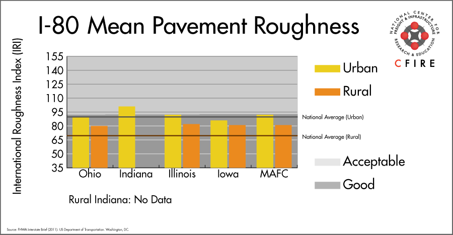
Infrastructure Condition
The International Roughness Index (IRI) measures the cumulative amount of vertical deviation (the bumpiness or roughness) for each segment of road, and is reported as a ratio in inches per mile. IRI values less than 95 are generally considered good, while values between 95 and 170 are generally considered acceptable. Since only corridor segments with reported IRI values from the 2011 HPMS dataset were considered in this analysis, some states may be missing from certain corridors.
The IRI is used as a measurement to determine infrastructure conditions within the Highway Performance Monitoring System (HPMS) such as pavement deterioration, pavement condition trends, cost allocation studies, and other analytical purposes. It is reported, at a minimum, for all road segments that fall under the Full Extent classification which includes the National Highway System (NHS), all principal arterials (interstates, freeways, and expressways), and rural minor arterials within the Sample Panel dataset. The data is collected by the states and submitted to the FHWA. The FHWA verifies the data, and houses it within the HPMS. For more historical information, see MnDOT’s Introduction to the International Roughness Index.
Freight Facilities
Intermodal Terminals
- BNSF Logistics Park in Joliet (IL): TOFC-COFC
- Canadian National Harvey (IL) Intermodal Terminal: TOFC-COFC
- Canadian National Joliet (IL): TOFC-COFC
- Union Pacific Council Bluffs: COFC
- UP Global IV in BNSF Logistics Park Joliet: TOFC-COFC
- Union Pacific (UP) Yard Center Dolton, IL: (<300,000 lifts/yr.)
- Norfolk Southern Sandusky, OH: RoadRailer
Major Rail Yards
- Iowa: Main
- Ohio: Walbridge, Stanley, Rossford, Maumee, Ford Yard, Bellevue, Lordstown
- Illinois: Barr, Yard Center, Joliet, Markham
Airports
- Toledo Express (TOL)
- Des Moines International (DSM)
- Eppley Airfield (OMA)
- Cleveland-Hopkins International (CLE)
- The Eastern Iowa Airport (CID)
Ports
- Port of Cleveland
- Port of Toledo – Lucas County
- Port of Indiana – Burns Harbor
- Port of Gary
- Port of Chicago
Automotive Distribution Centers
- Joliet BNSF
- South Bend Vehicle Ramp
- Oliver Yard
- Elkhart Ramp
- Nappanee
- CN Autoport – Markham@Harvey
- Council Bluff -UP
- Elkhart Auto Terminal
- Lordstown, OH
Freight Rail
Many heavy volume (greater than 100 million gross tons-MGT) lines cross this corridor for small segments of a time. There is no one rail line that parallels the corridor for its entirety.
Emerging Intermodal
The INland Logistics Port-Kingsbury in LaPorte County, Indiana opened in 2013. CSX, which has access to the facility, will offer expedited service from the Port of Tampa with perishable food products for distribution to the Midwest. The importance of the facility reflects a first attempt at moving perishables by train via the east coast.
Passenger Rail
While there is no single line that traverses this entire corridor, there are a few segments that are within the I-80 corridor as well as some that cross the corridor. Beginning in the east, the segments and their corresponding services that are within the corridor are: small segment around the Elyria, OH station, and west of Toledo (Lake Shore Limited); South Bend (station) west to Gary (Capitol Limited, and Lake Shore Limited), and a short segment in Omaha (California Zephyr). There are three stations on routes that cross the corridor: Homewood, IL (City of New Orleans, and Illinois Service), Joliet, IL (Texas Eagle, Illinois Service) and Princeton, IL (Southwest Chief, California Zephyr, Illinois Service). Another service that crosses the corridor near Dyer, IN is the Cardinal/Hoosier State.
Airports
There are five air cargo airports that service the I-80 corridor.
- DSM in Des Moines, OMA in Omaha, CLE in Cleveland, and CID in Cedar Rapids along the I-80 corridor are all considered primary hub airports. They rank 10th, 12th, 13th, and 15th, respectively within the MAFC region, and 49th, 52nd, 59th, and 76th nationally. Each of these four airports maintain air cargo facilities for both UPS and FedEx Express.
- TOL in Toledo ranked 24th within the MAFC region and 107th nationally. TOL is considered a primary hub airport, and was the former air cargo hub for BAX Global. Neither UPS nor FedEx have an air cargo facility at TOL.
| Toledo Express (TOL)) | Des Moines International (DSM) | Eppley Airfield (OMA) | Cleveland-Hopkins International (CLE) | The Eastern Iowa Airport (CID) | |
| Cargo Facilities | Bonded Warehouse, Transit Zone, Free Port/Foreign Trade Zone, Mechanical Handling, Heated Storage, Air-Conditioned Storage, Refrigerated Storage, X-Ray Equipment, Security for Valuables, Dangerous Goods, Radioactive Goods, Very Large/Heavy Cargo | Capacity 210 000tonnes (462 966,000lbs), Free Port/Foreign Trade Zone, Mechanical Handling, Health Officials, Security for Valuables, Express/Courier Centre | Domestic Cargo Only, Mechanical Handling, Heated Storage, Refrigerated Storage, Security for Valuables, Very Large/Heavy Cargo, Express/Courier Centre | Bonded Warehouse, Mechanical Handling, Heated Storage, Livestock Handling, Security for Valuables, Dangerous Goods, Radioactive Goods, Very Large/Heavy Cargo, Express/Courier Centre, Handling Equipment: K loader 20,000 lbs forklift, freight dolly; Cargo Handling Agents: Servisair/GlobeGround | Capacity 36 325tonnes (80 082,000lbs), Bonded Warehouse, Free Port/Foreign Trade Zone, Express/Courier Centre |
| Cargo Terminals | 1 | 2 | 5 | 1 | 4 |
| Number of Runways (max. length) | 2 (10,600 feet) | 2 (9,002 feet) | 3 (9,501 feet) | 4 (8,999 feet) | 2 (8,602 feet) |
| Warehouses & DCs within 5/10 miles | 1 / 5 | 2 / 32 | 7 / 23 | 15 / 24 | 4 / 9 |
| Air Cargo Businesses within Urban Area | 254 | 133 | 226 | 1,180 | 133 |
| 2011 Landed Weight (lbs.) | 650,714,500 | 425,198,660 | 393,907,878 | 369,077,012 | 210,618,182 |
| 2010 Landed Weight (lbs.) | 894,480,320 | 434,435,240 | 404,708,486 | 380,855,675 | 206,621,220 |
| Change (Percentage) | -27.25% | -2.13% | -2.67% | -3.09% | 1.93% |
| Intermodal Connectors (5/10 miles) | 5 / 6 | 5 / 7 | 0 / 4 | 16 / 29 | 2 / 2 |
Ports
Both M-90/M-87 and M-70 could potentially serve as Marine Highway reliever routes to I-80 in the eastern United States. M-90 provides navigable water access from Duluth, MN and Chicago, IL in the west to New York/New Jersey in the east via either the St. Lawrence Seaway or the Erie Canal/Hudson River (M-87). Freight currently moving via I-80 could by-pass some or all of I-80 as far as west as Chicago depending on proximity to Great Lakes ports. The M-90 Great Lakes ports closest to I-80 are in the western Ohio port cluster from Cleveland, OH to Toledo, OH and the southern Lake Michigan port cluster from Burns Harbor, IN to Chicago, IL. Shipments needing to travel west of Chicago could continue by river barge via M-55/western M-70 as far as Kansas City, MO or even rejoin I-80 at Sioux City, IA using M-29.

Freight Generators, Warehouses, and Distribution Centers
There are a total of 30,068 freight generators employing 492,423 people within three miles of the I-80 corridor, and a total of 83,845 freight generators employing 1,353,359 people within 10 miles of the corridor. If the extent of analysis focuses on the metropolitan statistical areas (MSAs) intersected by the I-80 corridor, there are a total of 197,055 freight generators employing 3,108,641 people. Within the MSAs, there are a total of 748 warehousing and distribution centers employing 12,780 people. Freight generators were determined by using the NAICS codes prescribed for freight-related sectors in NCFRP Report 19, and include agriculture, mining, manufacturing, wholesale trade, retail trade, transportation and warehousing, and eating and drinking places.
Major Manufacturers |
Major Distribution Centers |
|
|
References
- FHWA Interstate Brief (2011). US Department of Transportation.