DRAFT
Kansas City, Missouri to Sioux City, Iowa
Snapshot: Length: 746 miles | Length in MAFC: 281 miles | Intersecting Interstates: I-35, I- 70, I-80, I-90, I-94
I-29 is a major north-south corridor passing through both Missouri and Iowa in the MAFC. I-29 begins in Kansas City, MO, running north as a concurrent route with I-35 and US-71, parallel to the Missouri River to St. Joseph, MO where the concurrent routes are dropped and I-29 continues north along the river. I-29 crosses into Iowa at Hamburg, IA and continues north along the Missouri River. I-29 leaves Iowa at Sioux City, IA and crosses into Sioux City, SD. In total, I-29 traverses four states: Missouri, Iowa, South Dakota, and North Dakota. I-29 crosses into Canada at the Pembina/Emerson border crossing. It is the most heavily traveled border crossing in North Dakota and one of only three crossings in the state that are open 24 hours a day (1).
In the MAFC region, I-29 is classified as a Tier 1 corridor. Additionally, as a 24-hour border crossing and a major north-south route, I-29 has been designated as a NAFTA corridor as well as a High Priority Corridor in the 1998 TEA-21 legislation. I-29 serves as the primary freight corridor for north-south truck traffic through the Dakotas.
This role may figure more prominently as North Dakota oil resources continue to be developed. I-29 also runs near the Missouri River, a section of which that runs from Kansas City, MO to Sioux City, IA has been designated a Marine Highway (M-29) by the US Maritime Administration. This program and designation is intended to support movement of containerized and roll-on/roll-off (RORO) cargo from interstates to the waterways. The parallel river facility is also a constraint at times. In 2011, I-29 was closed for more than three months due to flooding. And the river has forced the closure of I-29 numerous times since the historic 1993 flooding on the Missouri. While rail and marine freight services are parallel to I-29 as it crosses Missouri and Iowa, these facilities are similarly affected by flooding and are generally not available to accommodate the displaced north-south freight. And similar to trucks on the highway, the rail and waterway modes have generally been forced to find alternate routes or delay shipments during flood periods
In Iowa, I-29 is part of the commercial and industrial network (2). There are four I-29 bridges on Iowa’s list of embargoed bridges for permitted loads (3). Iowa DOT also provides county and city maps of restricted routes and vertical clearances for loads on major corridors such as I-29 (4). There is only one major project on I-29 in Iowa: I-29 Improvement Project. This project is designed to enhance safety and operation of the interstate in Sioux City, IA (5). In Missouri, I-29 is part of the designated federal and state commercial network (6). With the upgrade of US-71 to I-49 from the Missouri state line to Kansas City, I-49 and I-29 connect in Kansas City and combined the two interstates cover 1,630 miles. This corridor links the Gulf Coast ports at New Orleans with Winnipeg, Canada (7). Missouri also recently completed the Interstate 29/35 Connections project completing major work on this urban interstate as well as replacing a major river crossing on the Missouri River (8).
I-29 begins in Kansas City Missouri, the 31st largest MSA, and connects to St. Joseph, MO. In Iowa, I-29 connects Hamburg, Council Bluffs (where it is concurrent with I-80), and Sioux City before connecting to South Dakota. With the conversion of US-71 to I-49 in Missouri, this corridor provides a border-to-border connection between the Gulf Coast and Mid-Continent Canada.


Metropolitan Statistical Areas Economic Profile
| MSA | Population | GDP (2011, in millions) | Employment | Freight-related Employment | Metropolitan Planning Organizations |
| Sioux City (IA) | 168,563 | $6,279 | 81,091 | 36,544 | Sioux City Metropolitan Planning Council |
| Omaha-Council Bluffs (IA-NE) | 865,350 | $48,979 | 506,335 | 186,374 | Omaha/Council Bluffs Metropolitan Area Planning Agency |
| St. Joseph (KS-MO) | 127,329 | $4,679 | 67,449 | 30,770 | St. Joseph Area Transportation Study Organization |
| Kansas City (MO-KS) | 2,009,342 | $108,144 | 1,036,081 | 398,896 | Mid-America Regional Council |
| Grand Forks (ND-MN) | 98,461 | $4,227 | 61,814 | 20,404 | Grand Forks – East Grand Forks MPO |
| Fargo (ND-MN) | 208,777 | $12,420 | 125,405 | 49,990 | Fargo-Moorhead Metropolitan Council of Government |
National Connectors
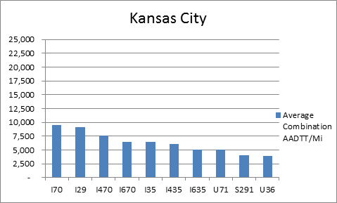
Kansas City
The interstates supporting freight originating in, destined for, and traveling through Kansas City, MO include I-29, I-35, I-49B, and I-70. In total, Kansas City has 30 urban interstates, freeways, and expressways that support freight movements. I-70 and its national connectors I-470 and I-670 are three of the top four roadways ranked by the average combination AADTT per mile. In total I-70, I-470, and I-670 carry 26.7 percent of truck miles traveled on urban interstates, freeways, and expressways within Kansas City.
Freight Projects Impacting Truck Traffic
Several recent projects have been undertaken on I-29 to complete routine maintenance and rehabilitation work. Currently, there no major highway projects that will significantly impact the flow of freight in the corridor. However, with the upgrade of US-71 to I-49 from the Missouri state line to Kansas City, I-49 and I-29 now connect in Kansas City; combined the two interstates cover 1,630 miles. This corridor links the Gulf Coast ports at New Orleans with Winnipeg, Canada (9). Missouri also recently completed the Interstate 29/35 Connections project, completing major work on the urban interstate as well as replacing a major river crossing on the Missouri River (10).
Truck Traffic
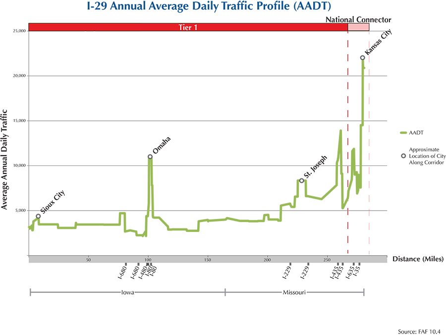
I-29 is a 281-mile corridor that crosses two states in the MAFC: Iowa and Missouri.
- VMT 2007: 5,971,435
- Truck VMT 2007: 1,316,030
- Percent Truck VMT: 22 percent
Operational Efficiency (ITS)
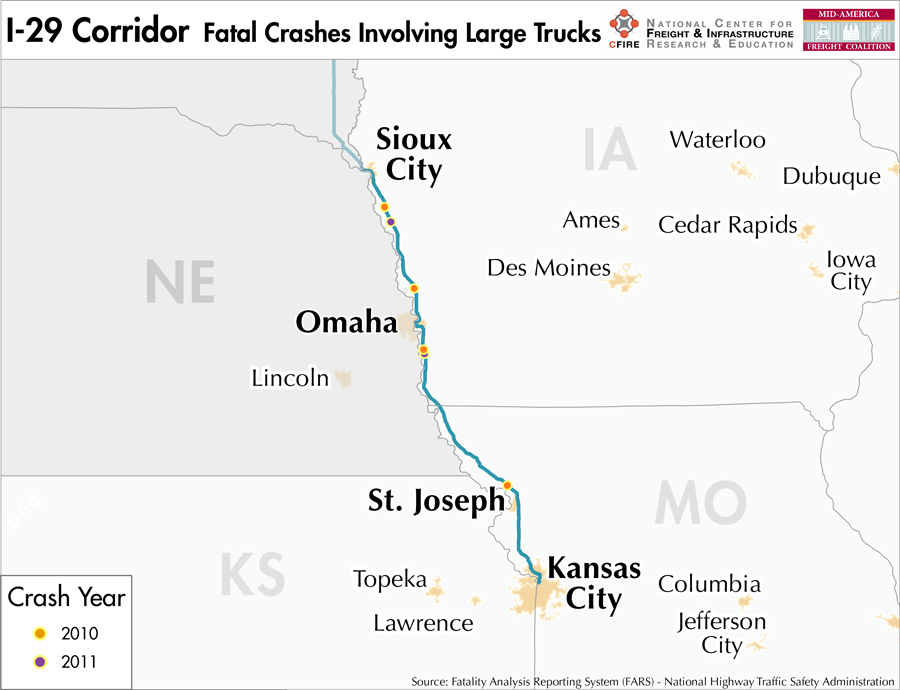
All 30 of the cameras found on the I-29 Corridor are located within 15 miles of Kansas City, with a majority (22) located within the bounds of the urban area. Conversely, most (15) message boards are found in Iowa, and throughout the corridor, more than half (55 percent) are found outside the boundaries of urban areas.
Iowa and Missouri collaborate with Kansas, Nebraska, and Oklahoma through ITS Heartland. The Iowa DOT participates in the ENTERPRISE Pool Fund Study.
Greenhouse Gas Emissions
- Yearly tons of CO2 assuming 4 mpg: 800,000
- Yearly tons of CO2 assuming 7.5 mpg: 430,000
Methodology
- Data: Truck Counts (HPMS 2011)
- Assume 4 and 7.5 miles per gallon
- No control for level of service or elevation changes
- 22.3 lbs. of CO2 per gallon of Diesel
Fuel and Truck Parking
| There are 18 fueling stops that also offer truck parking along I-29. Five truck stops have less than 25 parking stops, 8 have between 25-84 spots, and 5 have 85+ parking spots. Compressed Natural Gas (CNG) and Liquified Natural Gas (LNG) stations are listed to the right. | I-29 | CNG | LNG |
| Public | 0 | 0 | |
| Private | 3 | 0 | |
| Planned | 0 | 0 | |
| Total | 3 | 0 |
Infrastructure Condition
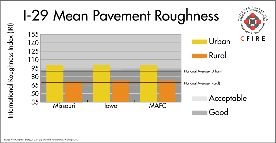
The International Roughness Index (IRI) measures the cumulative amount of vertical deviation (the bumpiness or roughness) for each segment of road, and is reported as a ratio in inches per mile. IRI values less than 95 are generally considered good, while values between 95 and 170 are generally considered acceptable. Since only corridor segments with reported IRI values from the 2011 HPMS dataset were considered in this analysis, some states may be missing from certain corridors.
The IRI is used as a measurement to determine infrastructure conditions within the Highway Performance Monitoring System (HPMS) such as pavement deterioration, pavement condition trends, cost allocation studies, and other analytical purposes. It is reported, at a minimum, for all road segments that fall under the Full Extent classification which includes the National Highway System (NHS), all principal arterials (interstates, freeways, and expressways), and rural minor arterials within the Sample Panel dataset. The data is collected by the states and submitted to the FHWA. The FHWA verifies the data, and houses it within the HPMS. For more historical information, see MnDOT’s Introduction to the International Roughness Index.
Freight Facilities
Intermodal Terminals
- Union Pacific (UP) and Iowa Interstate Railroad System (IAIS) joint facility in Council Bluffs: COFC (<25K lifts/yr.)
- Union Pacific (UP) Neff Yard: TOFC-COFC
Major Rail Yards
- Northeast Industrial District in Kansas City includes Neff Yard (UP), Knoche Joint Agency Yard (Operated by the KCS and Iowa, Chicago and Eastern (IC&E).
- Avondale Yard: Kansas City
Airports
- Kansas City International (MCI)
- Eppley Airfield (OMA)
Ports
- Port of Kansas City
Automotive Distribution Centers
- Omaha Vehicle Facility (BNSF)
- GM Fairfax (UP)
- Council Bluff (UP)
Freight Rail
This corridor is a multimodal corridor. The Union Pacific (UP) and the Burlington Northern-Santa Fe (BNSF) railroads run parallel to I-29 for most of the corridor. UP runs south from Sioux City, IA until it intersects with the high density east-west UP Blair Subdivision. This segment is a light density line carrying 27 million annual gross tons (MGT) (11). Further to the south, BNSF railroad comes in from the east into Council Bluff (Omaha MSA) and heads south via the Council Bluffs Subdivision, Napier Subdivision, and St. Joseph Subdivision to Kansas City, MO. This entire segment is a high density (over 100 MGT) coal route as well as an intermodal and automotive route. BNSF classified this route as part of MIDCON Corridor, a strategic economic corridor for the railroad. The segment between St. Joseph and Kansas City mainly runs outside the I-29 six-mile buffer zone. The shortline Iowa Interstate Railroad System (IAIS) runs from Council Bluffs, IA to Chicago, IL. One of the UP’s top ten classification yards, Neff Yard is located in Kansas City, MO adjacent to I-29. Neff Yard has an average daily volume of 1,000 cars.
Passenger Rail
While a parallel passenger service does not exist in this corridor, two Amtrak stations are located in the corridor. The California Zephyr service has a station in Omaha, 1.5 miles west of I-29, and the Missouri River Runner service has a station in Kansas City, within the I-29 buffer zone.
Airports
There are two air cargo airports that service the I-29 corridor.
- MCI in Kansas City, MO is the 11th ranked commercial airport in the MAFC region in terms of landed weight while being ranked 50th nationally. MCI is serviced by both UPS and FedEx air cargo facilities, and is considered a primary hub airport.
- OMA in Omaha NE is ranked just behind MCI at 12th in terms of landed weight within the MAFC region while being ranked 52nd nationally. OMA is also home to both UPS and FedEx air cargo facilities, as well as considered a primary hub airport.
| Kansas City International (MCI) | Eppley Airfield (OMA) | |
| Cargo Facilities | Warehouse 30 000m2 (322,917 sq ft), Bonded Warehouse, Transit Zone, Free Port/Foreign Trade Zone, Aircraft Maintenance, Mechanical Handling, Heated Storage, Air-Conditioned Storage, Refrigerated Storage, Animal Quarantine, Fresh Meat Inspection, Health Officials, X-Ray Equipment, Security for Valuables, Dangerous Goods, Radioactive Goods, Very Large/Heavy Cargo, Express/Courier Centre, Handling Equipment: Airport owned CAS Wide-body Main Deck Loader for lease per use | Domestic Cargo Only, Mechanical Handling, Heated Storage, Refrigerated Storage, Security for Valuables, Very Large/Heavy Cargo, Express/Courier Centre |
| Cargo Terminals | 5 | 5 |
| Number of Runways (max. length) | 3 (10,800 feet) | 3 (10,800 feet) |
| Warehouses & DCs within 5/10 miles | 1/2 | 7/23 |
| Air Cargo Businesses within Urban Area | 626 | 226 |
| 2011 Landed Weight (lbs.) | 423,890,310 | 393,907,878 |
| 2010 Landed Weight (lbs.) | 431,918,705 | 404,708,486 |
| Change (Percentage) | -1.86% | -2.67% |
| Intermodal Connectors (5/10 miles) | 4/4 | 0/4 |
Ports
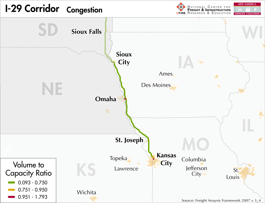
The M-29 Marine Highway is the navigable portion of the Missouri River and is intended to serve as an alternative to I-29 from the southeast corner of South Dakota to Kansas City, MO. Both routes follow the eastern border of Iowa and northwestern Missouri, and like the I-29 corridor, M-29 ends at Kansas City, MO. Sioux City, IA is the largest port at the northern end of the route, and as with most river ways, numerous other smaller ports and terminals along the river provide potential connectivity between interstate highways and the marine highway.
Kansas City serves as the junction between M-29 and M-70, the designation for the Missouri River between Kansas City and St. Louis, MO. The M-29/M-70 system provides a continuous navigable route to the rest of Mississippi River System.


Freight Generators, Warehouses, and Distribution Centers
There are a total of 8,344 freight generators employing 195,238 people within three miles of the I-29 corridor, and a total of 20,893 freight generators employing 400,704 people within 10 miles of the corridor. If the extent of analysis focuses on the metropolitan statistical areas (MSAs) intersected by the I-29 corridor, there are a total of 36,800 freight generators employing 652,584 people. Within the MSAs, there are a total of 224 warehousing and distribution centers employing 5,001 people. Freight generators were determined by using the NAICS codes prescribed for freight-related sectors in NCFRP Report 19, and include agriculture, mining, manufacturing, wholesale trade, retail trade, transportation and warehousing, and eating and drinking places.
Major Manufacturers |
Major Distribution Centers |
|
|
References
- Pembina Emerson Traffic Conditions.
- Iowa Commercial and Industrial Network. Iowa Department of Transportation.
- Iowa State Highway Map. Iowa Department of Transportation.
- Freight Maps, Data, and Tools. Iowa Department of Transportation.
- I-29 Improvement Project. Iowa Department of Transportation.
- Missouri Vehicle Route Map: 2012-2013. Missouri Department of Transportation.
- I-49 Conversion. Missouri Department of Transportation.
- Interstate 29/35 Connections Project. Missouri Department of Transporation.
- I-49 Conversion. Missouri Department of Transportation.
- Interstate 29/35 Connections Project. Missouri Department of Transportation
- Iowa’s Rail System Trends. Iowa Department of Transportation.
- FHWA Interstate Brief (2011). US Department of Transportation.