DRAFT
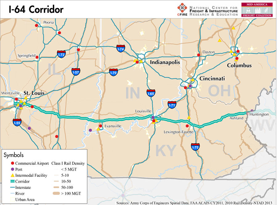
Wentzville, Missouri to the Kentucky/West Virginia Border
Snapshot: Length: 954 | Length in MAFC: 461 miles | Intersecting Interstates: I-55, I-57, I-65, I-69, I-70, I-71, I-75, I-77, I-81, I-95
I-64 is a major east-west corridor in the MAFC. Beginning at its connection with I-70 in Wentzville, MO, I-64 crosses four MAFC states. After crossing the Mississippi River at the Poplar Street Bridge with I-55 and I-70, I-64 then crosses Illinois, Indiana, and Kentucky. In addition to these four MAFC states, I-64 also crosses West Virginia and Virginia. The I-64 corridor connects the most western state in the coalition, Kansas, with the east coast via I-70 (1) and St. Louis.
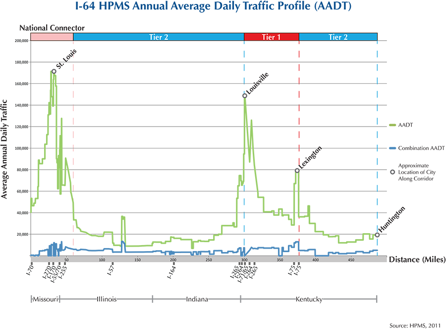
The I-64 corridor is classified as both a Tier 1 and a Tier 2 corridor in the MAFC framework. For the portion in Kentucky between I-65 and I-75, the corridor is considered a Tier 1 corridor due to heavy freight volumes related to the linkages with I-65 and I-75 and service to Louisville and Lexington. The remaining eastern and western portions of the corridor are considered Tier 2 corridors due to the lower freight volumes, but are important connections with other freight corridors and urban centers.
I-64 is the most southern east-west corridor in the region. I-64 connects with several major freight corridors starting with I-55 in Missouri, I-57, I-75, I-77, I-95 and I-81. In Missouri, I-64 is also known locally as US-40 and the facility serves as the southernmost portion of the Avenue of the Saints. In 2008 and 2009 a major rebuild was completed on I-64 that involved a shutdown of the corridor in two phases. Over the course of these two years, I-64 was completely rebuilt from Wentzville to the Poplar Street Bridge (2). After I-64 moves through East St. Louis, IL, it cuts across rural, southern Illinois and near the Mid-America Airport on the way to Indiana.
I-64 is a designated truck route in Missouri and Illinois, a commerce corridor in Indiana (3), and part of the Intermodal Freight Focus Network (4) and designated National Truck Network in Kentucky (5).
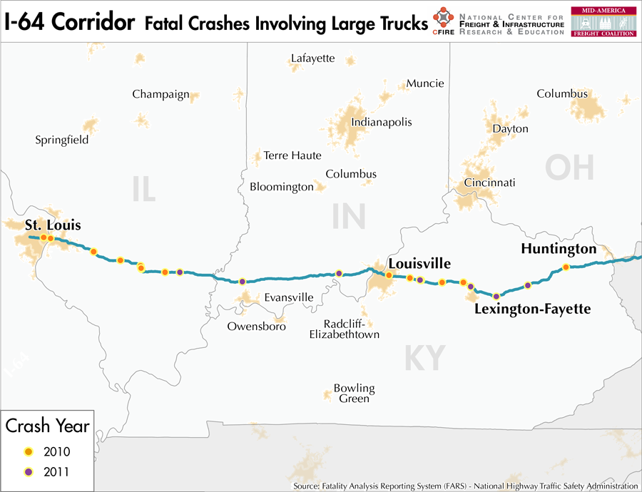
I-64 connects the communities and metropolitan areas of St. Louis, MO, East St. Louis, IL, and Mt. Vernon, IL. It then connects to Evansville, IN and Louisville, KY. From Louisville, I-64 continues through Frankfort, KY, Lexington, KY, Morehead, KY, and Ashland, KY before entering West Virginia at Huntington.
Metropolitan Statistical Areas Economic Profile
| MSA | Population | GDP (2011, in millions) | Employment | Freight-related Employment | Metropolitan Planning Organizations |
| St. Louis (MO-IL) | 2,787,701 | $132,029 | 1,338,018 | 502,178 | East-West Gateway Council of Governments |
| Evansville (IN-KY) | 311,552 | $17,221 | 201,568 | 91,529 | Evansville MPO |
| Louisville (KY-IN) | 1,235,708 | $5,588 | 46,893 | 18,573 | Kentuckiana Regional Planning and Development Agency |
| Lexington – Fayette (KY) | 472,099 | $22,782 | 250,846 | 103,215 | Lexington Area MPO |
| Huntington – Ashland (WV-KY-OH) | 364,908 | $10,850 | 116,931 | 42,238 | KYOVA Interstate Planning Commission |
National Connectors
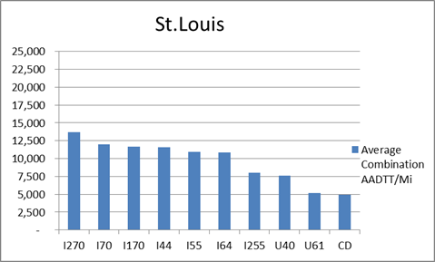
St. Louis
The interstates supporting freight originating in, destined for, and traveling through St. Louis are I-44, I-55, I-64, and I-70. In total, St. Louis has a total of 35 urban interstates, freeways, and expressways that support freight movements. I-70 and its national connectors I-270 and I-170 are the top three freight-carrying roadways ranked by average combination AADTT per mile. In total I-70, I-170, and I-270 carry 36.4 percent of truck miles traveled on urban interstates, freeways, and expressways within St. Louis.
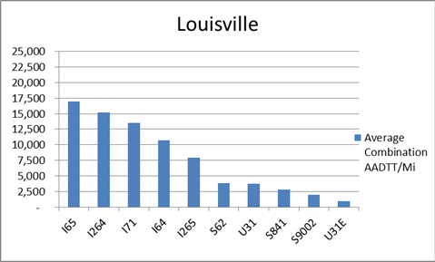
Louisville
The roadway supporting freight originating in, destined for, and traveling through Louisville includes I-64, I-65, and I-71. In total, Louisville has 11 urban interstates, freeways, and expressways that support freight movements. I-65, I-71, and I-64 rank one, three, and four respectively based on of the average combination AADTT per mile. Furthermore, I-64, I-65, and I-71 transport 76.7 percent of combination truck miles on urban interstates, freeways, and expressways within Louisville.
Freight Projects Impacting Truck Traffic
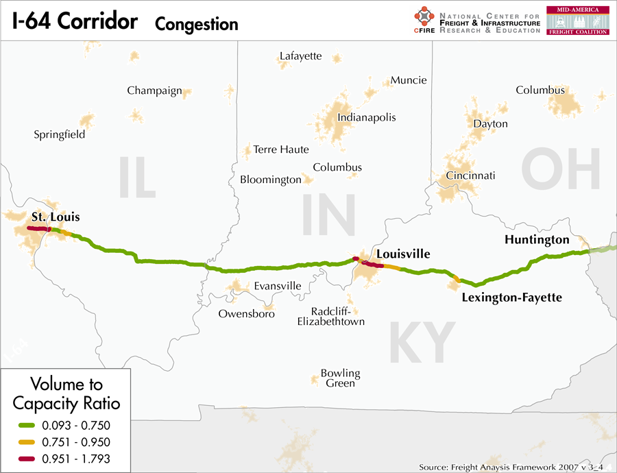
There are several major bridge projects that will affect the flow of traffic on I-64.
- In St. Louis, MO the Daniel Boone Bridge is being replaced. The current bridge was built in the mid-1930s and does not meet interstate design standards, leading to safety concerns and severe congestion at peak travel times.
- The Ohio River Bridges Project includes major reconstruction of the I-64/I-65/I-71 interchange in downtown Louisville, which currently sees some of the most severe congestion in the United States.
- In 2009, MoDOT completed the New I-64 project which included a complete closure of the interstate in two phases in order to rebuild the facility and ensure freight service on this important corridor.
Truck Traffic
I-64 is a 461-mile corridor that crosses four states in the MAFC: Missouri, Illinois, Indiana, and Kentucky.
- VMT 2007: 14,371,725
- Truck VMT 2007: 3,331,236
- Percent Truck VMT: 23.2 percent
Operational Efficiency (ITS)
Both cameras and message boards are tightly clustered around the major metropolitan areas intersecting the I-64 corridor. Of the 61 cameras found on the along the corridor, 29 are in St. Louis and the remaining 32 are in Louisville. Similarly, the 16 message boards are also tightly clustered around these large cities, with 11 in St. Louis and 2 in Louisville.
Illinois, Indiana, and Kentucky collaborate with Ohio through ITS Midwest, whereas Missouri partners with Iowa, Kansas, Nebraska, and Oklahoma through ITS Heartland. Additionally, the Illinois DOT participates in the ENTERPRISE Pool Fund Study.
Greenhouse Gas Emissions
- Yearly tons of CO2 assuming 4 mpg: 2,000,000
- Yearly tons of CO2 assuming 7.5 mpg: 1,100,000
Methodology
- Data: Truck Counts (HPMS 2011)
- Assume 4 and 7.5 miles per gallon
- No control for level of service or elevation changes
- 22.3 lbs. of CO2 per gallon of Diesel
Fuel and Truck Parking
| There are 30 fueling stations along I-64 that also offer truck parking. Eight fueling stations have less than 25 truck parking spaces, 11 have between 25 and 84 trucking parking spaces, and 11 have 85+ truck parking spaces. Compressed Natural Gas (CNG) and Liquefied Natural Gas (LNG) stations are listed to the right. | I-64 | CNG | LNG |
| Public | 1 | 0 | |
| Private | 0 | 0 | |
| Planned | 0 | 0 | |
| Total | 1 | 0 |
Infrastructure Condition
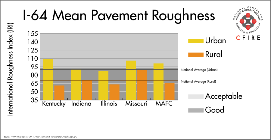
The International Roughness Index (IRI) measures the cumulative amount of vertical deviation (the bumpiness or roughness) for each segment of road, and is reported as a ratio in inches per mile. IRI values less than 95 are generally considered good, while values between 95 and 170 are generally considered acceptable. Since only corridor segments with reported IRI values from the 2011 HPMS dataset were considered in this analysis, some states may be missing from certain corridors.
The IRI is used as a measurement to determine infrastructure conditions within the Highway Performance Monitoring System (HPMS) such as pavement deterioration, pavement condition trends, cost allocation studies, and other analytical purposes. It is reported, at a minimum, for all road segments that fall under the Full Extent classification which includes the National Highway System (NHS), all principal arterials (interstates, freeways, and expressways), and rural minor arterials within the Sample Panel dataset. The data is collected by the states and submitted to the FHWA. The FHWA verifies the data, and houses it within the HPMS. For more historical information, see MnDOT’s Introduction to the International Roughness Index.
Freight Facilities
Intermodal Terminals
- Burlington Northern Santa Fe (BNSF)- Lindenwood- St. Louis: TOFC-COFC (<70,000 lifts/yr.)
- CSX Rose Lake Yard – East St. Louis: TOFC-COFC (>60,000 lifts/yr.)
- Norfolk Southern (NS Luther Yard – St. Louis: TOFC-COFC (>80,000 lifts/yr.)
- Norfolk Southern (NS) Appliance Park Louisville: COFC (<45,000 lefts/yr.)
Major Rail Yards
St. Louis
- Lindenwood
- 23rd Street Yard
- East St. Louis
- Venice
- Rose Lake
- Tower Grove
Louisville
- Youngstown
- Osborn
Airports
- Louisville International – Standiford Field (SDF)
- Lambert-St. Louis International (STL)
Ports
- Port of St. Louis
- Southeast Missouri Regional Port
- Port of Indiana – Mount Vernon
- Port of Louisville
- Port of Indiana – Jeffersonville
- Port of Huntington Tri-State
Automotive Distribution Centers
- Centreville, IL – Union Pacific
- Louisville, KY – KTP/LAP/Strawberry Yard
- Shelbyville, KY – Norfolk Southern
- Wentzville, MO – Norfolk Southern
- Princeton, IN – Toyota Facility
- Georgetown, KY – Toyota Facility
Freight Rail
Many railroads cross and follow the I-64 corridor for short distances. The only high-density routes (>100 million gross tons-MGT) are west of St. Louis, MO. According to the 2010 rail density data available from the 2013 National Transportation Atlas Database there are less heavy (50–100 MGT) north-south routes that cross the I-64 corridor. The CSX line near Evansville, IN connects to the Dixie Flyer Road COFC terminal. Even though this terminal is outside the I-64 corridor, I-164 leading to I-64 is the closest interstate. The Norfolk Southern First District Subdivision crosses at I-75. Lastly the CSX CC Subdivision crosses near Winchester, KY.
Passenger Rail
No passenger service exists that parallels this east-west corridor. A number of Amtrak services intersect this corridor. In St. Louis, the Texas Eagle, Missouri River Runner and the Lincoln services all stop in St. Louis MO, the only Amtrak station in this corridor. The City of New Orleans crosses the corridor near Richview, IL. The Cardinal/Hoosier State crosses the I-64 corridor near Catlettsburg, IL and stops in Ashland, KY.
Airports
There are two air cargo airports on the I-64 corridor.
- SDF in Louisville, KY was the top ranked commercial airport in the MAFC region in terms of landed weight in 2012. Nationally it ranked 3rd after Memphis, TN and Anchorage, AK. SDF is considered a primary hub airport, is home to UPS Worldport, and is serviced by FedEx Express.
- STL in St. Louis, MO was the 14th ranked commercial airport in the MAFC region for 2012 landed weight, and ranks nationally at 61st. STL is considered a primary hub airport, and is serviced by both UPS and FedEx air cargo facilities.
| Louisville International-Standiford Field (SDF) | Lambert-St Louis International (STL) | |
| Cargo Facilities | Domestic Cargo Only, Mechanical Handling, Heated Storage, Dangerous Goods, Express/Courier Centre, Parking space for large transient aircraft is very limited. | Capacity 4 479 700tonnes (9 875 946,000lbs), 2x 747 Freighter Docks, Bonded Warehouse, Free Port/Foreign Trade Zone, Aircraft Maintenance, Mechanical Handling, Heated Storage, Air-Conditioned Storage, Refrigerated Storage, X-Ray Equipment, Security for Valuables, Dangerous Goods, Radioactive Goods, Very Large/Heavy Cargo, Express/Courier Centre, New cargo facility development by Aeroterm of 22854 sq metres also available |
| Cargo Terminals | 1 | 2 |
| Number of Runways (max length) | 3 (10,849 feet) | 4 (11,020 feet) |
| Warehouses & DCs within 5/10 miles | 19/48 | 15/41 |
| Air Cargo Businesses within Urban Area | 283 | 845 |
| 2011 Landed Weight (lbs.) | 10,981,281,067 | 84,332,870 |
| 2010 Landed Weight (lbs.) | 10,637,700,120 | 371,026,650 |
| Change (Percentage) | 3.23% | 3.59% |
| Intermodal Connectors (5/10 miles) | 4/11 | 2/7 |
Ports and Marine Highways
The eastern M-70, which includes the Ohio River and the Mississippi River between the mouth of the Ohio River and the mouth of the Missouri River, could serve as a Marine Highway reliever route to I-64 between St. Louis, MO and Huntington, WV. Major ports include St. Louis, MO; SE Missouri Port, MO; Mt. Vernon, IN; Louisville, KY; Cincinnati, OH; and Huntington Tri-State. In addition, numerous smaller ports and terminals provide potential access between I-64 and M-70. Eastern M-70 is equipped with 1,200 foot locks and is open year round.

Freight Generators, Warehouses, and Distribution Centers
There are a total of 18,886 freight generators employing 323,757 people within three miles of the I-64 corridor, and a total of 43,250 freight generators employing 754,867 people within 10 miles of the corridor. If the extent of analysis focuses on the metropolitan statistical areas (MSAs) intersected by the I-64 corridor, there are a total of 61,324 freight generators employing 987,300 people. Within the MSAs, there are a total of 286 warehousing and distribution centers employing 7,053 people. Freight generators were determined by using the NAICS codes prescribed for freight-related sectors in NCFRP Report 19, and include agriculture, mining, manufacturing, wholesale trade, retail trade, transportation and warehousing, and eating and drinking places.
| Major Manufacturers | Major Distribution Centers |
|
|
References
- Interstate 64. Wikipedia.
- The New I-64. Missouri Department of Transportation.
- Maps. Indiana Department of Transportation.
- Intermodal Freight Focus Network. Kentucky Transportation Cabinet.
- National Truck Network. Kentucky Transportation Cabinet.
- FHWA Interstate Brief (2011). US Department of Transportation.