DRAFT
Port Huron, Michigan to Indianapolis, Indiana
Snapshot: Length: 590 miles | Length in MAFC: 361 miles | Intersecting Interstates: I-75, I-80, I-90, I-94, I-96
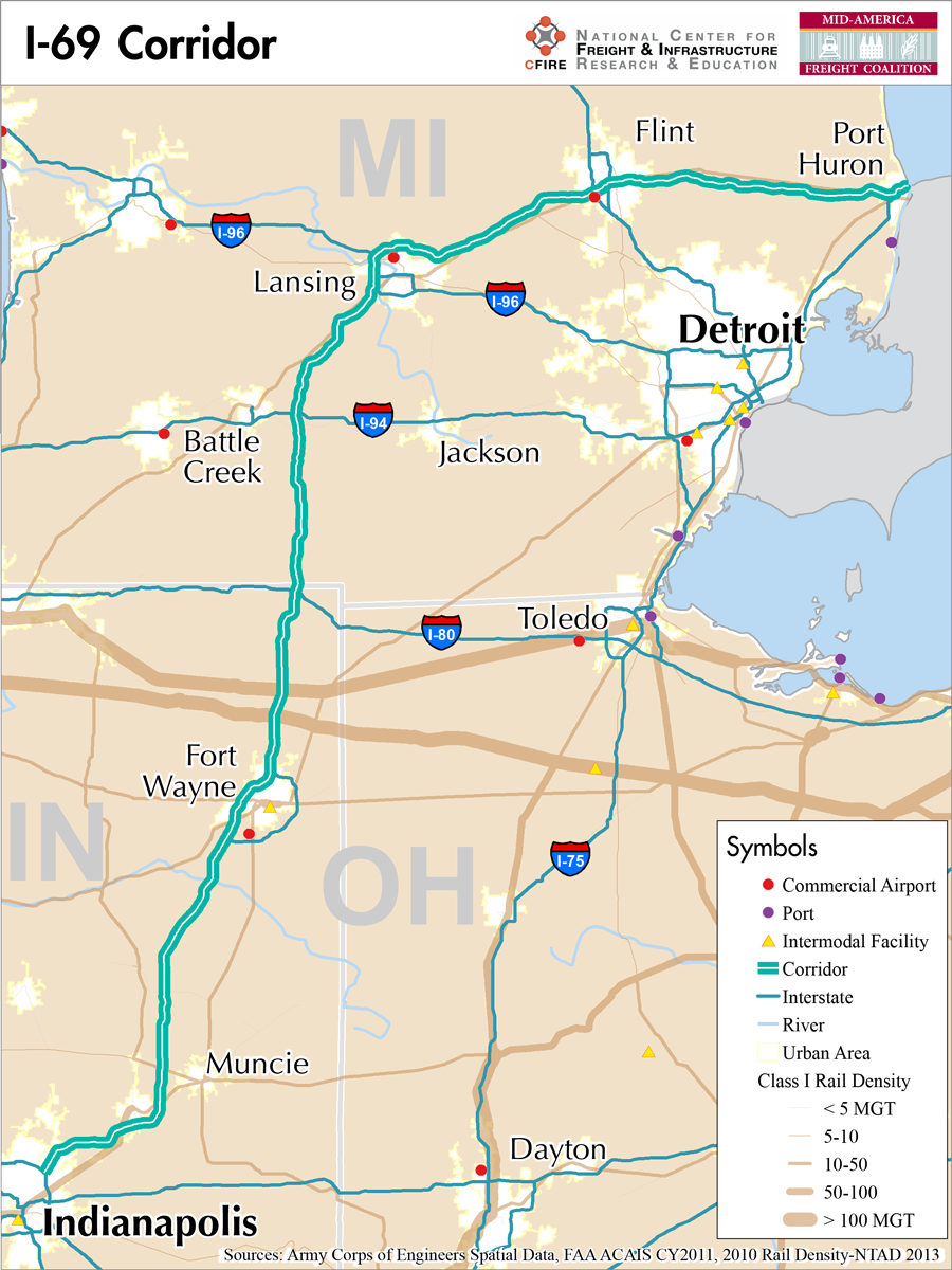
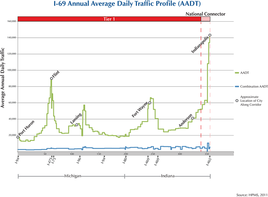
I-69 in a major north-south interstate in the MAFC region. I-69 begins in Port Huron, MI at the junction with I-94 and heads west towards Lansing, MI. I-69 then continues south through Michigan and Indiana (1).
I-69, often referred to as the NAFTA superhighway, is ultimately intended to connect Mexico and Canada with a trade route through the heart of the MAFC region. The superhighway concept relies on I-69 through Michigan and Indiana and a host of other routes in Kentucky, Tennessee, Mississippi, Louisiana, and Texas as it makes its way towards the Texas–Mexico border. In Texas, I-69 was part of the decommissioned Trans-Texas corridor (2). With its origin at Lake Huron and I-94, to its terminus at the Texas-Mexico border, this corridor provides tri-national connectivity, alignment with the auto sectors in the United States, Canada, and Mexico, access to the central and Great Lake markets, and access to the northeastern United States.
This corridor qualifies as a Tier 1 fright corridor in the MAFC nationally significant corridor network from its origin at Port Huron, Michigan to Indianapolis, Indiana. The high traffic volumes, current and proposed international connections, and multistate functions reflect the importance of this expanding corridor. Parallel rail service in close proximity is available across most of the route. A Great Lakes to Mississippi River route could replicate the national-level moves on I-69, however, the marine network would prove a much longer and circuitous as compared to a relatively straight north-south on-road route.
From Indianapolis, IN to the Kentucky border, I-69 has seen significant improvements. In 2011, the new alignment of I-69 was the longest contiguous section of new interstate construction (3).
The Michigan Truck Operator Map includes I-69 (4) and Michigan also provides weight tables, structures clearance tables, truck network tables and a list of bridges with special load limits (5). Indiana also includes I-69 in their commerce corridors, mobility corridors, and on the state’s High Priority Corridors Map (6).
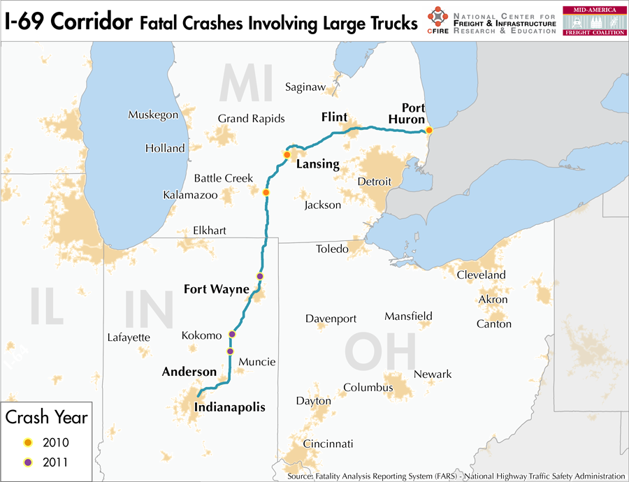
I-69 is not tolled in Michigan or Indiana. Communities and metro areas served by I-69 in the MAFC region include Port Huron, Flint, Lansing, Battle Creek and Marshall in Michigan. In Indiana, this section of I-69 services the communities of Fort Wayne, Anderson and Indianapolis.
Metropolitan Statistical Areas Economic Profile
| MSA | Population | GDP (2011, in millions) | Employment | Freight-related Employment | Metropolitan Planning Organizations |
| Detroit (MI) | 4,296,250 | $199,378 | 1,862,383 | 782,451 | Southeast Michigan Council of Governments |
| Flint (MI) | 425,790 | $11,325 | 153,124 | 59,042 | Genesee County Metropolitan Planning Commission |
| Lansing-East Lansing (MI) | 464,036 | $19,256 | 240,435 | 72,908 | Tri-County Regional Planning Commission |
| Battle Creek (MI) | 136,146 | $4,755 | 61,027 | 29,701 | Battle Creek Area Transportation Study |
| Fort Wayne (IN) | 416,257 | $18,278 | 222,219 | 97,758 | Northeastern Indiana Regional Coordinating Council |
| Muncie (IN) | 117,671 | $3,466 | 48,339 | 18,225 | Delaware-Muncie Metropolitan Plan Commission |
| Anderson (IN) | 131,636 | $3,115 | 41,760 | 15,060 | Madison County Council of Governments |
| Indianapolis (IN) | 1,887,877 | $103,815 | 925,961 | 323,431 | Indianapolis MPO |
National Connectors
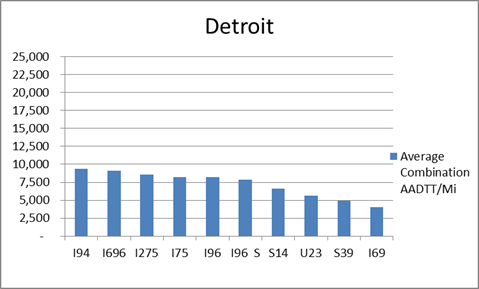
Detroit
The interstates supporting freight originating in, destined for, and traveling through Detroit include I-94, I-75, and I-96. In total, Detroit has 23 urban interstates, freeways, and expressways that support freight movements. Detroit has a largely dispersed distribution of freight throughout its 23 urban connectors based on average combination AADTT per mile. The top four roadways by average combination AADTT per mile are I-94, I-696, I-275, and I-75.
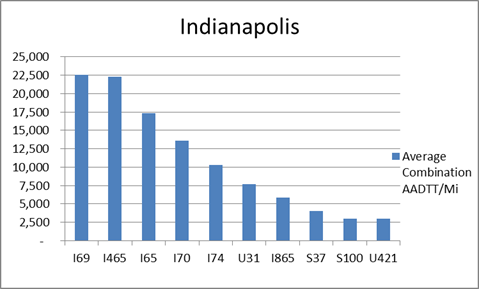
Indianapolis
The interstates supporting freight originating in, destined for, and traveling through Indianapolis include I-74, I-70, I-65, I-70, and I-69. In total, Indianapolis has 12 urban interstates, freeways, and expressways that support freight movements. I-69, I-65, and I-70 rank one, three, and four respectively based on average combination AADTT per mile. Furthermore, I-69, I-65, and I-70 transport 58.5 percent of combination truck miles on urban interstates, freeways, and expressways within Indianapolis.
Freight Projects Impacting Truck Traffic
I-69 is one of the only highways being built on new alignment in the United States. It is also one of the six highways designated by the federal government as a Corridor of the Future and essential to future freight flows in the United States. It will eventually stretch from Canada to Mexico.
- Important current construction in the MAFC includes the portion of I-69 from Evansville to Indianapolis in Indiana. At the peak of construction in 2011, this was the largest continuous stretch of new highway construction in the United States.
- Kentucky’s portion of I-69 includes a new Ohio River bridge in Fulton, KY as well as the upgrading of roughly 160 miles of parkways to interstate standards. Some of this work has been completed while other work has yet to begin as plans are finalized.
Truck Traffic
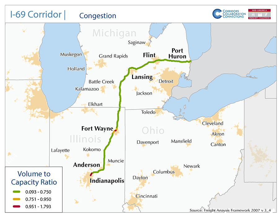
I-69 is a 361-mile corridor that crosses two states in the MAFC: Michigan and Indiana.
- VMT 2007: 11,684,519
- Truck VMT 2007: 2,972,470
- Percent Truck VMT: 25.4 percent
Operational Efficiency (ITS)
There are 11 message boards and 22 cameras located along the I-69 corridor. Message boards are distributed fairly evenly throughout the corridor, with just over half (55 percent) found in urban areas. The greatest concentration of cameras is in Indianapolis (12). However, there is also clustering around Port Huron, with 8 cameras within 5 miles of the city limits.
Michigan has an individual membership in ITS America, whereas Indiana collaborates with Illinois, Kentucky, and Ohio through ITS Heartland. Additionally, the Michigan DOT participates in the ENTERPRISE Pool Funded Study.
Greenhouse Gas Emissions
- Yearly tons of CO2 assuming 4 mpg: 1,400,000
- Yearly tons of CO2 assuming 7.5 mpg: 770,000
Methodology
- Data: Truck Counts (HPMS 2011)
- Assume 4 and 7.5 miles per gallon
- No control for level of service or elevation changes
- 22.3 lbs. of CO2 per gallon of Diesel
Fuel and Truck Parking
| There are 26 fueling stations along I-69 that also offer truck parking. Seven fueling stations have less than 25 truck parking spaces, nine have between 25 and 84 truck parking spaces, and 10 have 85+ truck parking spaces. Compressed Natural Gas (CNG) and Liquefied Natural Gas (LNG) stations are listed to the right. | I-69 | CNG | LNG |
| Public | 1 | 0 | |
| Private | 0 | 0 | |
| Planned | 0 | 1 | |
| Total | 1 | 1 |
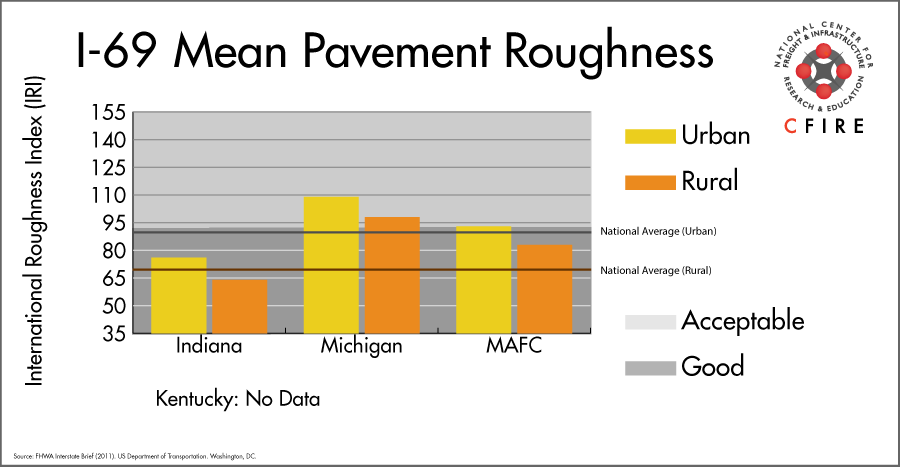
Infrastructure Condition
The International Roughness Index (IRI) measures the cumulative amount of vertical deviation (the bumpiness or roughness) for each segment of road, and is reported as a ratio in inches per mile. IRI values less than 95 are generally considered good, while values between 95 and 170 are generally considered acceptable. Since only corridor segments with reported IRI values from the 2011 HPMS dataset were considered in this analysis, some states may be missing from certain corridors.
The IRI is used as a measurement to determine infrastructure conditions within the Highway Performance Monitoring System (HPMS) such as pavement deterioration, pavement condition trends, cost allocation studies, and other analytical purposes. It is reported, at a minimum, for all road segments that fall under the Full Extent classification which includes the National Highway System (NHS), all principal arterials (interstates, freeways, and expressways), and rural minor arterials within the Sample Panel dataset. The data is collected by the states and submitted to the FHWA. The FHWA verifies the data, and houses it within the HPMS. For more historical information, see MnDOT’s Introduction to the International Roughness Index.
Freight Facilities
Intermodal Terminals
- Norfolk Southern (NS) Triple Crown-RoadRailer
- CSX Dixie Flyer Road: Evansville, IL: COFC (emerging portion of corridor)
Major Rail Yards
- Garrett, IN
- Torry, IN
- Port Huron, MI
- Evansville, IN (emerging portion of corridor)
Automotive Distribution Centers
- Roanoke, IN – GM Facility
- Lansing, MI – CN Autoport
- Grand River, MI- CN Autoport
Freight Rail
There is parallel freight service in this corridor from Samia to Bellevue, MI with freight volumes from 10-50 million gross tons (MGT) according to freight rail density data from the 2013 National Transportation Atlas Database. A small segment near Indianapolis from Anderson to Ingalls, has volumes between 50 and 100 million MGT.
Passenger Rail
Passenger service is available in the I-69 corridor on Amtrak’s Blue Water service from Port Huron to Chicago. Stations within the corridor are Port Huron, Lapeer, Flint, and Durand. This service is subsidized by the State of Michigan.
Three routes cross the I-69 corridor. The Wolverine with service from Detroit/Pontiac to Chicago crosses the corridor near Marshall, MI. The Wolverine route is a federally designated high-speed rail corridor that is owned by Amtrak. The Capitol Limited and the Lake Shore Limited stop in Waterloo, Indiana.
Airports
There are four air cargo airports on the I-69 corridor.
IND in Indianapolis is the second-ranked airport in the MAFC region and fifth nationally. FWA in Fort Wayne, LAN in Lansing, and FNT in Flint handle considerably less freight than IND, and rank 21st, 23rd, and 25th respectively in the MAFC region while ranking 91st, 102nd, and 117th nationally. UPS and FedEx both have an air cargo facility at IND and FWA, while UPS services LAN and FedEx Express has a presence at FNT.
| Indianapolis International (IND) | Fort Wayne International (FWA) | Capital Region International (LAN) | Bishop International (FNT) | |
| Cargo Facilities | Bonded Warehouse, Free Port/Foreign Trade Zone, Aircraft Maintenance, Express/Courier Centre | Warehouse 26 600m² (286 320sq ft), 12x 747 Freighter Docks, Free Port/Foreign Trade Zone, Very Large/Heavy Cargo, Express/Courier Centre, 32 acre Air Apron with direct access to Warehouse, Handling Equipment | Mechanical Handling | Free Port/Foreign Trade Zone |
| Cargo Terminals | 4 | 1 | 3 | |
| Number of Runways (max. length) | 3 (11,200 feet) | 3 (12,001 feet) | 3 (7,250 feet) | 2 (7,847 feet) |
| Warehouses & DCs within 5/10 miles | 16 / 34 | 3 / 17 | 6 / 13 | 7 / 18 |
| Air Cargo Businesses within Urban Area | 533 | 152 | 121 | 122 |
| 2011 Landed Weight (lbs.) | 4,813,314,835 | 169,772,460 | 119,644,880 | 73,214,150 |
| 2010 Landed Weight (lbs.) | 4,717,295,655 | 170,959,305 | 116,049,240 | 78,571,800 |
| Change (Percentage) | 2.04% | -0.69% | 3.10% | -6.82% |
| Intermodal Connectors (5/10 miles) | 8 / 9 | 0 / 3 | 1 / 1 | 0 / 0 |
Ports and Marine Highways
There are no navigable waterways that directly serve as Marine Highway reliever routes to I-69 between Port Huron, MI and the state of Indiana north of the Ohio River. Freight shipped between points in Michigan and or southern Great Lakes ports could use M-75 (between Lake Huron and Toledo, Ohio) or M-90 (between Lake Huron and the four upper Great Lakes). Freight shipped on I-69 between northern and southern Indiana could be shipped by water between Lake Michigan ports (M-90) and Ohio River ports connected by M-55 (Illinois River, Mississippi River), and eastern M-70 (Ohio River).

Freight Generators, Warehouses, and Distribution Centers
There are a total of 11,421 freight generators employing 199,608 people within three miles of the I-69 corridor, and a total of 29,309 freight generators employing 476,563 people within 10 miles of the corridor. If the extent of analysis focuses on the metropolitan statistical areas (MSAs) intersected by the I-69 corridor, there are a total of 89,161 freight generators employing 1,398,576 people. Within the MSAs, there are a total of 356 warehousing and distribution centers employing 13,332 people. Freight generators were determined by using the NAICS codes prescribed for freight-related sectors in NCFRP Report 19, and include agriculture, mining, manufacturing, wholesale trade, retail trade, transportation and warehousing, and eating and drinking places.
| Major Manufacturers | Major Distribution Centers |
|
|
References
- Interstate 69. Wikipedia.
- I-69 Trans-Texas Corridor Study. Transportation for Communities.
- I-69 Evansville to Indianapolis Project. Indiana Department of Transportation.
- Truck Operator Map: 2012. Michigan Department of Transportation.
- Maps and Publications. Michigan Department of Transportation.
- Indiana’s 2013-2035 Future Transportation Needs Report. Indiana Department of Transportation.
- FHWA Interstate Brief (2011). US Department of Transportation.