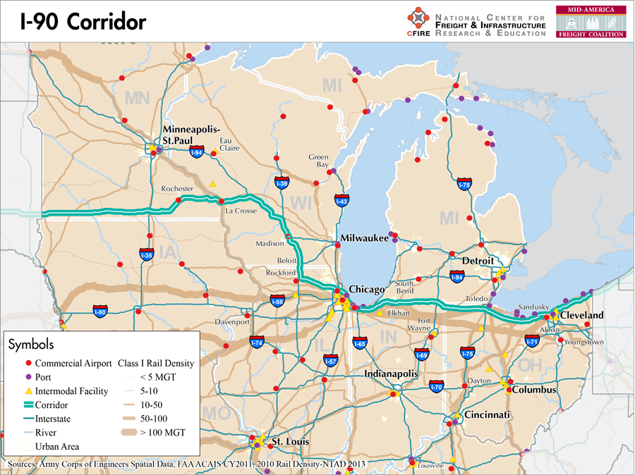
Western Minnesota to Eastern Ohio
Snapshot: Length: 3,101 miles | Length in MAFC: 973 miles | Intersecting Interstates: I-5, I-15, I-25, I-35, I-43, I-55, I-65, I-75, I-87, I-95
I-90 traverses the United States from the Seattle, WA on the Pacific Coast to Boston, MA on the Atlantic Coast. This route across the United States makes it the nation’s longest Interstate. Within the MAFC region, I-90 passes through five states: Minnesota, Wisconsin, Illinois, Indiana and Ohio. I-70 and I-94 are the only other major corridors to cross five MAFC states. For a significant portion of its extent within the MAFC region, I-90 runs concurrent with other Interstates. In Wisconsin, it joins I-94 and then I-39, before I-94 splits off again at Madison. The stretch from Portage, when it joins I-39, to Madison is the longest running of concurrent Interstates in the nation. Across the majority of Indiana and Ohio, I-90 is concurrent with I-80 and becomes the Indiana Toll Road and Ohio Turnpike.
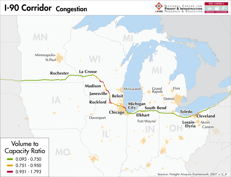
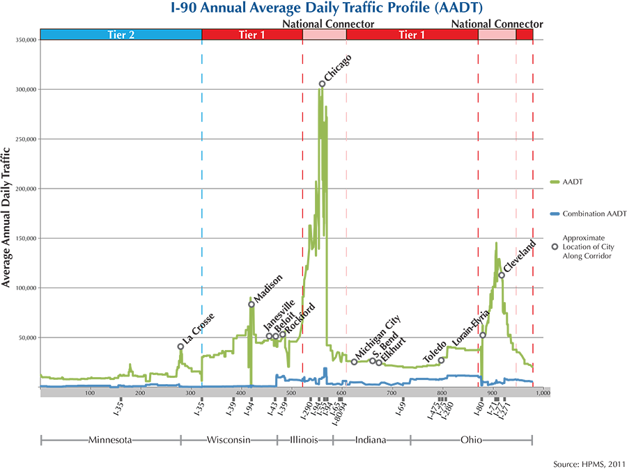
From the South Dakota-Minnesota boarder to Tomah, WI, the MAFC Regional Freight Study categorizes I-90 as a Tier 2 Nationally Significant Freight Corridor based on its traffic volume and proximity to important regional cities. Once it joins I-94 in west central Wisconsin, traffic volumes increase and the classification is increased to Tier 1, partly reflective of its importance in bringing goods from the Twin Cities region through Wisconsin and northern Illinois to Chicago and beyond. Continuing east from Chicago concurrent with I-80, Interstate 90 serves as an important east-west corridor to the Ohio shores of Lake Erie. After passing through Cleveland, it heads northeast after separating from I-80, and leaves the MAFC for Pennsylvania and then New York.
Tolls are in place for roughly half of the distance I-90 covers within the MAFC region. Tolling begins shortly after the Wisconsin-Illinois border with the Jane Adams Memorial Tollway. Tolls are absent east of O’Hare International Airport through downtown Chicago and resume at the beginning of the Chicago Skyway when I-90 and I-94 separate south of the downtown. When I-90 crosses the Illinois state line into Indiana, it marks the beginning of the Indiana Toll Road and is soon joined by I-80. The Indiana Toll Road continues across northern Indiana, not far from the Michigan border and becomes the Ohio Turnpike upon crossing that border. I-90 remains tolled across northern Ohio until it enters the greater Cleveland area when the Turnpike continues east along I-80 and I-90 turns northeast along the lakefront. It is not tolled for the rest of its extent through northeast Ohio.
I-90 is approved as part of Minnesota’s Twin Trailer Network although it does not qualify for their Super Load Corridors classification due to height restrictions under interstate bridges. Wisconsin designates I-90 as an official Long Truck Route and Illinois also lists it as a Designated Truck Route. It is one of Indiana’s Commerce Corridors and is included in Access Ohio’s Strategic Transportation System.
The route followed by I-90 can be roughly followed using freight rail lines belonging to Canadian Pacific west of Chicago and Norfolk Southern east of Chicago. No waterway serves the entire route of I-90, although many of the major cities situated along the corridor have access to lakes and rivers suitable for moving freight. Interstate 90 has the companion marine highway of M-90. This M-90 corridor is defined as the Great Lakes, Erie Canal and connecting commercial navigation channels, ports, and harbors from Albany, NY to Chicago, IL., and Duluth, MN. As defined in the Marine Highway specifications, M-90 can provide freight relief to both I-90 and I-80 and offers unlimited capacity from western Lake Superior to the east coast.
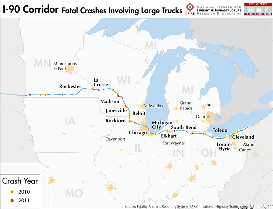
After leaving Sioux Falls, SD just outside the MAFC regions western boundaries, I-90 travels by a number of communities along the southern portion of Minnesota, not far from the Iowa border. It approaches Rochester after turning slightly northward before continuing east to cross the Mississippi into La Crosse, WI. Major cities along I-90’s route through WI include Madison, Janesville and Beloit, after which I-90 crosses into Illinois, where it turns east at Rockford and passes Elgin before entering the Chicago metro area. Exiting Chicago into northern Indiana, I-90 visits Gary, South Bend and Elkhart on its way to the Ohio border. In Ohio, it passes south of Toledo and through Elyria into Cleveland, continuing along the lakeshore through Mentor and several smaller communities before leaving the MAFC region for Pennsylvania.
Metropolitan Statistical Areas Economic Profile
| MSA | Population | GDP (2011, in millions) | Employment | Freight-related Employment | Metropolitan Planning Organizations |
| Rochester (MN) | 206,877 | $9,409 | 88,613 | 32,611 | Rochester/Olmsted Council of Governments |
| La Crosse (WI-MN) | 133,665 | $5,835 | 77,576 | 35,405 | Mississippi River Planning Commission |
| Madison (WI) | 605,435 | $36,526 | 418,168 | 129,459 | Dane County Regional Planning Commission |
| Janesville (WI) | 160,331 | $4,983 | 75,548 | 30,455 | Janesville Urbanized Area MPO |
| Rockford (IL) | 349,431 | $12,959 | 171,486 | 76,957 | Rockford Area Transportation Study |
| Chicago (IL) | 9,461,105 | $547,609 | 4,333,730 | 1,706,242 | Chicago Metropolitan Agency on Planning |
| Michigan City-La Porte (IN) | 111,467 | $3,671 | 49,115 | 21,084 | Northwestern Indiana Regional Planning Commission |
| South Bend-Mishawaka (IN-MI) | 319,224 | $12,782 | 148,445 | 59,443 | Michiana Area Council of Governments |
| Elkhart-Goshen (IN) | 197,559 | $9,111 | 122,847 | 76,397 | Michiana Area Council of Governments |
| Toledo (OH) | 610,001 | $28,037 | 341,253 | 137,872 | Toledo Metropolitan Area Council of Governments |
| Sandusky (OH) | 77,079 | $3,190 | 49,837 | 20,797 | Erie Regional Planning Commission |
| Cleveland (OH) | 2,077,240 | $106,810 | 1,095,636 | 427,398 | Northeast Ohio Areawide Coordinating Agency |
National Connectors
Cleveland, OH
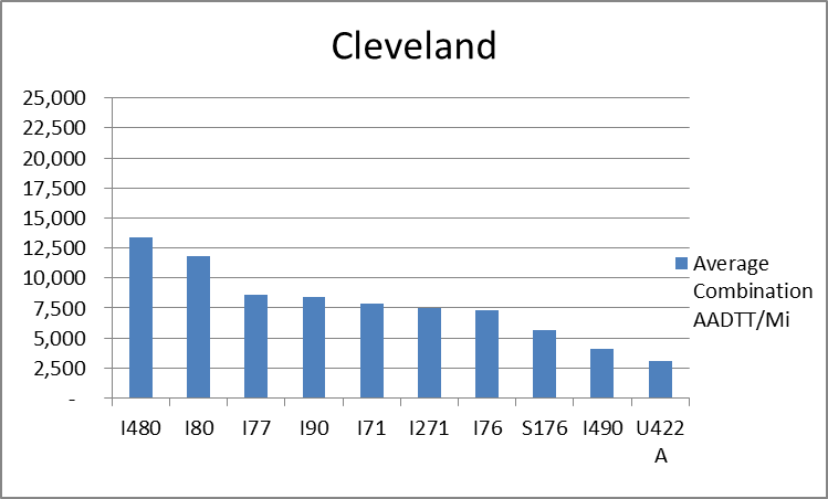
The interstates supporting freight originating in, destined for, and traveling through Cleveland include I-90, I-80, I-76, and I-71. In total, Cleveland has 21 urban interstates, freeways, and expressways that support freight movements. 33.1 percent of combination truck miles traveled on urban interstates, freeways, and expressways in Cleveland are on I-80 and I-480. Additionally, I-480 and I-80 are ranked first and second based on average combination AADTT per mile respectively.
Chicago, IL
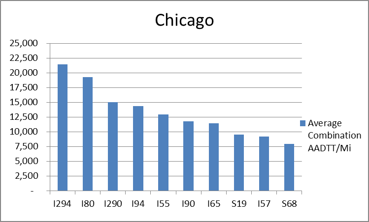
The interstates supporting freight originating in, destined for, and traveling through Chicago include I-55, I-57, I-88, I-89, I-90, and I-94. In total, Chicago has 42 urban interstates, freeways, and expressways that support freight movements. Chicago’s geographic location as a crossroad of numerous interstates causes a dispersion of freight throughout a large network of national connectors and interstates that travel through the city. The average combination AADTT per mile on Chicago’s urban interstates, freeways, and expressways is over 10,000 trucks for seven roadways and nearly 20,000 combination trucks for two roadways.
Freight Projects Impacting Truck Traffic
- Elgin O’Hare Western Access (EOWA) Project: Due to the overall magnitude of the project and potential to dramatically improve mobility, freight connectivity and enhance the national and regional economies, the EOWA Project is considered a Project of National and Regional Significance by the U.S. Department of Transportation.
- Wisconsin Expansion Project from Illinois State Border to Madison: To accommodate increased traffic flows, 35 percent of which is currently heavy trucks, this four-lane highway will be expanded to six lanes throughout this stretch and eight lanes for a segment through Janesville. All 11 interchanges will also be upgraded to meet current design standards.
- Cleveland’s I-90 Innerbelt Bridge: Improvements to the Innerbelt Bridge system will relieve congestion that causes transportation delays and also improve access to the Cleveland Port Authority.
- Reconstruction of I-90 Mississippi River Bridge: Besides solving the structural deficiencies exhibited by the current bridge, the new bridge should help to eliminate current capacity issues which lead to eastbound delays in the mornings, westbound delays in the evening, and overall delays in the event of accidents or maintenance requirements.
Truck Traffic
I-90 is a 973-mile corridor that crosses five states in the MAFC: Minnesota, Wisconsin, Illinois, Indiana, and Ohio.
- VMT 2007: 36,016,839
- Truck VMT 2007: 8,098,372
- Percent Truck VMT: 22.5 percent
Operational Efficiency (ITS)
The I-90 Corridor presents great variability in the distribution of message boards (13) and cameras (67), although there is a general clustering of both message boards (9) and cameras (48) in urban areas. Of the five states that I-94 crosses, cameras are only found in Ohio, Wisconsin, and Illinois. The highest concentrations are found in Cleveland (35) and Madison (6). Message boards are also distributed irregularly along the I-94 corridor, with the majority (7) found in Cleveland, 1 in Indiana, and 5 in Wisconsin, but are absent from Minnesota and Illinois.
Minnesota and Wisconsin have individual memberships to ITS America, whereas Illinois, Indiana, and Ohio collaborate with Kentucky through ITS Midwest. Additionally, the Minnesota and Illinois DOTs participate in the ENTERPRISE Pool Fund Study.
Greenhouse Gas Emissions
- Yearly tons of CO2 assuming 4 mpg: 3,800,000
- Yearly tons of CO2 assuming 7.5 mpg: 2,000,000
Methodology
- Data: Truck Counts (HPMS 2011)
- Assume 4 and 7.5 miles per gallon
- No control for level of service or elevation changes
- 22.3 lbs. of CO2 per gallon of diesel
Fuel and Truck Parking
| There are 90 fueling stops that also offer truck parking along I-90. Seventeen truck stops have less than 25 parking spots, 51 have between 25-84 spots, and 22 have 85+ parking spots. Compressed Natural Gas (CNG) and Liquified Natural Gas (LNG) stations are listed to the right. | I-90 | CNG | LNG |
| Public | 3 | 1 | |
| Private | 12 | 0 | |
| Planned | 2 | 3 | |
| Total | 17 | 4 |
Infrastructure Condition
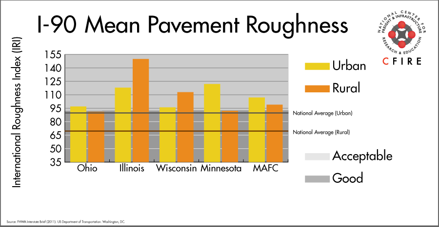
The International Roughness Index (IRI) measures the cumulative amount of vertical deviation (the bumpiness or roughness) for each segment of road and is reported as a ratio in inches per mile. IRI values less than 95 are generally considered good, while values between 95 and 170 are generally considered acceptable. Since only corridor segments with reported IRI values from the 2011 HPMS dataset were considered in this analysis, some states may be missing from certain corridors.
The IRI is used as a measurement to determine infrastructure conditions within the Highway Performance Monitoring System (HPMS) such as pavement deterioration, pavement condition trends, cost allocation studies, and other analytical purposes. It is reported, at a minimum, for all road segments that fall under the Full Extent classification which includes the National Highway System (NHS), all principal arterials (interstates, freeways, and expressways), and rural minor arterials within the Sample Panel dataset. The data is collected by the states and submitted to the FHWA. The FHWA verifies the data and houses it within the HPMS. For more historical information, see MnDOT’s Introduction to the International Roughness Index.
Freight Facilities
Intermodal Terminals
- BNSF Cicero, IL: TOFC-COFC (<40,000 lifts/yr.)
- BNSF Corwith, Chicago, IL: TOFC-COFC (<80,000 lifts/yr.)
- Norfolk Southern (NS) 47th Street, Chicago: TOFC-COFC
- Norfolk Southern (NS) 63rd Street, Chicago: TOFC-COFC
- Norfolk Southern (NS) Calumet: TOFC-COFC
- Union Pacific (UP) Global 1 Chicago: COFC (<40,000 lifts/yr.)
- CSX 59th Street Chicago: COFC
- CSX Collinwood Cleveland: TOFC-COFC
Major Rail Yards
- Illinois: Bensenville, Calumet, Chicago 47th St., East Chicago, Global I
- Ohio: Bellevue, Collinwood, Campbell, Conneaut, Walbridge, Stanley
Airports
- Chicago O’Hare International (ORD)
- Chicago/Rockford International (RFD)
- Toledo Express (TOL)
- Cleveland-Hopkins International (CLE)
Ports
- Port of Cleveland
- Port of Toledo – Lucas County
- Port of Indiana – Burns Harbor
- Port of Gary
- Port of Chicago
Automotive Distribution Centers
- Belvidere Assembly Plant: Belvidere, IL (UP)
- Chicago Mixing Center-Chicago, IL (NS)
- Avon Lake, Ohio (NS)
- Elkhard Auto Terminal-Elkhart, IL (NS)
Freight Rail
Frac Sand mining in Western Wisconsin and Eastern Minnesota are resulting in more train activity in the region. Unit trains to Texas and crude trains from North Dakota are crossing the corridor. A parallel freight line can be found for about half of the corridor with long segments from La Crosse to Madison; Chicago to South Bend; and Lorain, OH to Pennsylvania.
Emerging Intermodal
Improved efficiencies in Chicago through improvements spearheaded by the CREATE Program, the National Gateway and the Heartland Corridor projects are resulting in shorter intermodal domestic moves and increased truck to rail diversion.
Passenger Rail
There are a few segments of passenger rail within the I-90 corridor. Starting in the east, from the Pennsylvania border to Cleveland, the Lake Shore Limited has a station in Cleveland. The segment approximately from to Burns Harbor, IN to Morton Grove, IL includes portions of the Michigan Services (Blue Water, Pere Marquette, Wolverine) and Hiawatha. In Wisconsin, the Empire Builder is in the I-90 Corridor from Portage to Winona.
Airports
There are four air cargo airports that service the I-90 corridor.
- ORD in Chicago is the 3rd ranked air cargo airport in the MAFC region and ranked 6th nationally in terms of 2012 landed cargo weight. UPS and FedEx air cargo facilities are both present at ORD, and it is considered a primary hub airport.
- RFD in Rockford, CLE in Cleveland, and TOL in Toledo are all considered primary hub airports. In 2012 these airports ranked 6th, 13th, and 24th respectively within the MAFC region for landed weight, and 27th, 59th, and 107th nationally. UPS has air cargo facilities at RFD and CLE, and FedEx Express has an air cargo facility at CLE.
| Chicago O’Hare International (ORD) | Chicago/Rockford International (RFD) | Toledo Express (TOL) | Cleveland-Hopkins International (CLE) | |
| Cargo Facilities | Mechanical Handling, Heated Storage, Air-Conditioned Storage, Refrigerated Storage, Deep Freeze Storage, Mortuary, Animal Quarantine, Fresh Meat Inspection, Health Officials, X-Ray Equipment, Decompression Chamber, Security for Valuables, Dangerous Goods, Radioactive Goods, Very Large/Heavy Cargo, Express/Courier Centre Cargo; Handling Agents:Evergreen/EAGLE, Servisair/GlobeGround | Bonded Warehouse, Transit Zone, Free Port/Foreign Trade Zone, Mechanical Handling, Heated Storage, Air-Conditioned Storage, Refrigerated Storage, X-Ray Equipment, Security for Valuables, Dangerous Goods, Radioactive Goods, Very Large/Heavy Cargo | Bonded Warehouse, Mechanical Handling, Heated Storage, Livestock Handling, Security for Valuables, Dangerous Goods, Radioactive Goods, Very Large/Heavy Cargo, Express/Courier Centre, Handling Equipment: K loader 20,000 lbs forklift, freight dolly; Cargo Handling Agents: Servisair/GlobeGround | |
| Cargo Terminals | 15 | 1 | 1 | |
| Number of Runways (max. length) | 5 (12,998 feet) | 2 (10,600 feet) | 4 (8,999 feet) | |
| Warehouses & DCs within 5/10 miles | 27 / 56 | 5 / 11 | 1 / 5 | 15 / 24 |
| Air Cargo Businesses within Urban Area | 3,339 | 196 | 254 | 1,180 |
| 2011 Landed Weight (lbs.) | 4,368,420,500 | 888,721,860 | 650,714,500 | 369,077,012 |
| 2010 Landed Weight (lbs.) | 4,895,940,100 | 917,260,300 | 894,480,320 | 380,855,675 |
| Change (Percentage) | -10.77% | -3.11% | -27.25% | -3.09% |
| Intermodal Connectors (5/10 miles) | 7 / 28 | 0 / 0 | 5 / 6 | 16 / 29 |
Ports
M-90 is the designated Marine Highway reliever route for the I-90 from Chicago, IL to the Atlantic seaboard and potentially provides a continuous water route to New York City via the St. Lawrence Seaway or the Erie Canal/Hudson River (M-87). I-90 closely parallels the southern shore of Lake Erie and Lake Michigan and is close to the greatest concentration of large Great Lakes commercial ports in northern Ohio, Indiana, and Illinois. These include Ashtabula, OH; Cleveland, OH; Toledo, OH; Burns Harbor, IN; Gary, IN; Port of Indiana; Chicago, IL and others. Freight shipped by M-90 between Lake Erie and southern Lake Michigan is less direct than I-90, but the economies of shipping and avoiding land-side congestion could offset these disadvantages. M-90 provides a more direct route to some northern ports on Lakes Huron, Superior, and northern Lake Michigan than rail or highway alternatives. M-90, along with M-75 and M-71/77, could potentially provide the greatest relief to congested land routes by providing short sea shipping service between tightly clustered commercial ports in Lake Erie, the Detroit/St. Clair River, and southern Lake Michigan.

Freight Generators, Warehouses, and Distribution Centers
There are a total of 62,015 freight generators employing 986,339 people within three miles of the I-90 corridor, and a total of 133,703 freight generators employing 2,068,147 people within 10 miles of the corridor. If the extent of analysis focuses on the metropolitan statistical areas (MSAs) intersected by the I-90 corridor, there are a total of 175,762 freight generators employing 2,754,120 people. Within the MSAs, there are a total of 573 warehousing and distribution centers employing 10,847 people. Freight generators were determined by using the NAICS codes prescribed for freight-related sectors in NCFRP Report 19, and include agriculture, mining, manufacturing, wholesale trade, retail trade, transportation and warehousing, and eating and drinking places.
Major Manufacturers |
Major Distribution Centers |
|
|
References
- FHWA Interstate Brief (2011). US Department of Transportation.