North Dakota/Minnesota Border to Port Huron, Michigan
Snapshot: Length: 1,585 miles | Length in MAFC: 1,010 miles | Intersecting Interstates: I-29, I-35, I-43, I-55, I-65, I-69, I-75, I-80, I-90
I-94 is the northernmost east-west Interstate Highway. Its western terminus is in Billings, MT at a junction with I-90, while its eastern terminus is in Port Huron, MI at the Canadian border. Outside the MAFC region, I-94 travels through Montana and North Dakota, while within the region it visits major cities in Minnesota, Wisconsin, Illinois, Indiana and Michigan.
West of Minneapolis I-94 has a much lower traffic volume than across the rest of its extent. With the lower freight volumes in this section, I-94 is classified as an emerging corridor by the MAFC Regional Freight Study. Along this extent it still provides essential access to communities in western Minnesota and is an essential link to North Dakota and Montana. In North Dakota it is the only Interstate Highway other than I-29 which runs along the eastern border. Once it begins to approach the suburbs of Minneapolis-St. Paul, I-94 is classified as a Tier 1 corridor based on freight traffic density within the upper Midwest and Great Lakes states.
I-94 is tolled briefly north of Chicago to just south of the Wisconsin state line as part of the Tri-State Tollway. Other than this 25.5 mile stretch, the highway corridor is not tolled. Minnesota includes I-94 as a core route on its trucking network maps, Wisconsin shows it as a designated long truck route and Illinois lists it as a designated truck route. In Indiana it is included in the state commerce corridors designation by the DOT and in Michigan it is listed as a major route in the Truck Operator’s Map.
I-94 can be closely approximated by a Canadian Pacific railroad route from the Twin Cities to Detroit or by a combination of BNSF and Norfolk Southern tracks meeting in Chicago. A significant portion of the route has access to waterways but there is no east-west water route that could approximate I-94. M-94, Avenue of the Saints is a Marine Highway connector proposed by 5 MAFC states (Illinois, Iowa, Missouri, Minnesota and Wisconsin) to connect the upper Mississippi River to the Marine Highways system. The proposed M-94 connector stretches from the confluence of the Illinois River with the Mississippi at Grafton, IL, to the upper locks of the Mississippi River at Minneapolis between Minnesota and Wisconsin. The Connector’s linkage to the M-55 Corridor will provide a direct water route to the Gulf of Mexico from the Upper Midwest.
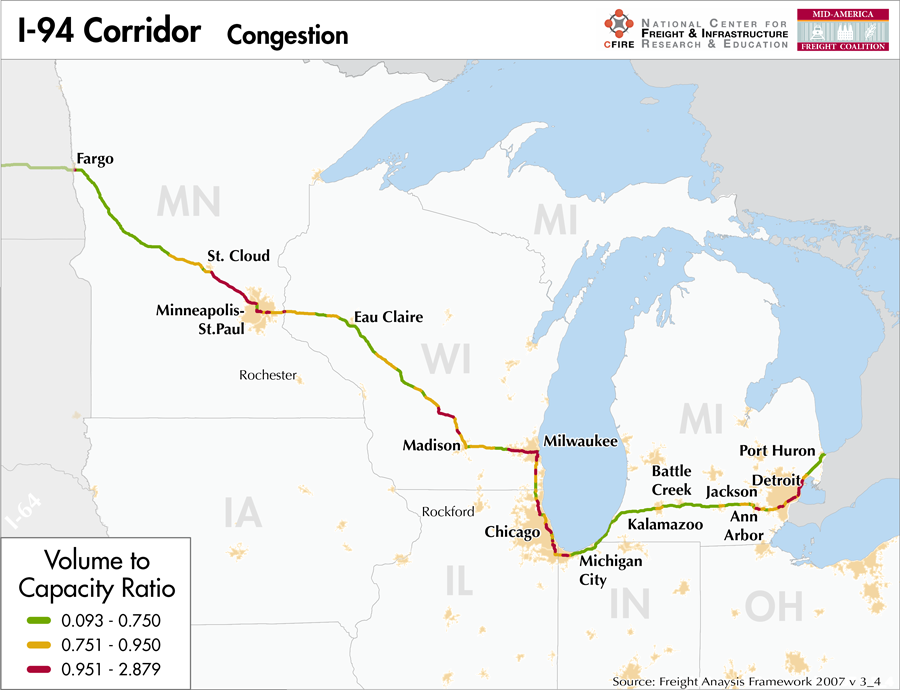
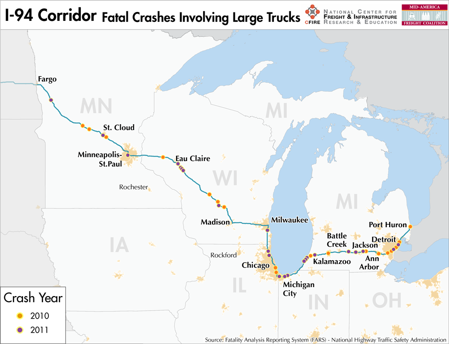
I-94 enters the MAFC region at Moorhead, MN, passing through St. Cloud, Minneapolis and St. Paul in Minnesota then entering Wisconsin, where it travels past Eau Claire, Madison, Waukesha, Milwaukee and heads south to Illinois, past Racine and Kenosha. In Illinois, it passes Waukegan and into the northern suburbs of Chicago, continuing through downtown and into Indiana where it passes Gary and Michigan City. In Michigan, I-94 crosses Kalamazoo, Battle Creek, Jackson-Blackman and Ann Arbor before entering the greater Detroit area. From downtown Detroit it heads northwest and crosses into Canada in Port Huron, MI.

Metropolitan Statistical Areas Economic Profile
| MSA | Population | GDP (2011, in millions) | Employment | Freight-related Employment | Metropolitan Planning Organizations |
| Fargo (ND-MN) | 208,777 | $12,420 | 125,405 | 49,990 | Fargo-Moorhead Metropolitan Council of Government |
| St. Cloud (MN) | 189,093 | $7,756 | 99,019 | 46,485 | St. Cloud Area Planning Organization |
| Minneapolis-St. Paul (MN) | 3,348,859 | $207,819 | 1,879,085 | 716,724 | Twin Cities Metropolitan Council |
| Eau Claire (WI) | 161,151 | $6,433 | 93,092 | 43,691 | Chippewa-Eau Claire MPO |
| Madison (WI) | 605,435 | $36,526 | 418,168 | 129,459 | Dane County Regional Planning Commission |
| Milwaukee (WI) | 1,555,908 | $87,539 | 879,954 | 362,515 | Southeastern Wisconsin Regional Planning Commission |
| Racine (WI) | 195,408 | $6,808 | 82,865 | 38,702 | Southeastern Wisconsin Regional Planning Commission |
| Chicago (IL) | 9,461,105 | $547,609 | 4,333,730 | 1,706,242 | Chicago Metropolitan Agency on Planning |
| Michigan City-La Porte (IN) | 111,467 | $3,671 | 49,115 | 21,084 | Northwestern Indiana Regional Planning Commission |
| Niles-Benton Harbor (MI) | 156,813 | $5,570 | 80,353 | 34,497 | Niles/Buchanan/Cass Area Transportation Study |
| Kalamazoo-Portage (MI) | 326,589 | $12,390 | 169,984 | 71,302 | Kalamazoo Area Transportation Study |
| Battle Creek (MI) | 136,146 | $4,755 | 61,027 | 29,701 | Battle Creek Area Transportation Study |
| Jackson (MI) | 160,248 | $4,971 | 60,736 | 23,622 | Jackson Area Transportation Study |
| Ann Arbor (MI) | 344,791 | $18,689 | 191,824 | 63,991 | Washtenaw Area Transportation Study |
| Detroit (MI) | 4,296,250 | $199,378 | 1,862,383 | 782,451 | Southeast Michigan Council of Governments |
National Connectors
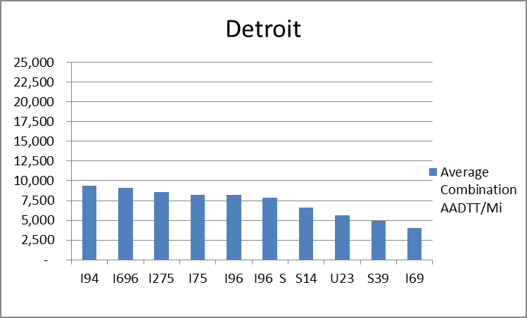
Detroit, MI
The interstates supporting freight originating in, destined for, and traveling through the Detroit include I-94, I-75, and I-96. In total, Detroit has 23 urban interstates, freeways, and expressways that support freight movements. Detroit has a widely dispersed distribution of freight throughout its 23 urban connectors based on average combination AADTT per mile. The top four roadways by average combination AADTT per mile are I-94, I-696, I-275, and I-75.
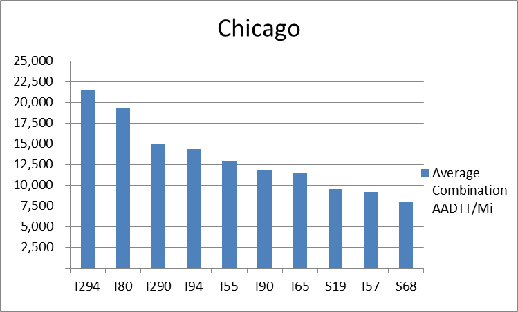
Chicago, IL
The interstates supporting freight originating in, destined for, and traveling through Chicago includeI-55, I-57, I-88, I-89,I-90, and I-94. In total, Chicago has 42 urban interstates, freeways, and expressways that support freight movements. Chicago’s geographic location as a crossroad of numerous interstates causes a dispersion of freight throughout a large network of national connectors and interstates that travel through the city. The average combination AADTT per mile on Chicago’s urban interstates, freeways, and expressways is over 10,000 trucks for seven roadways and nearly 20,000 combination trucks for two roadways.
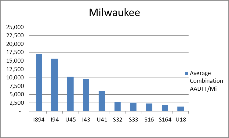
Milwaukee, WI
The interstates supporting freight originating in, destined for, and traveling through Milwaukee include I-94 and I-43. In total, Milwaukee has 12 urban interstates, freeways, and expressways that support freight movements. I-94 and I-894 are the top two average combination AADTT per mile with 44.9 percent of the combination truck miles traveled on urban interstates, freeways, and expressways within Milwaukee.
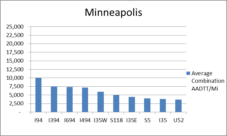
Minneapolis, MN
The interstates supporting freight originating in, destined for, and traveling through Minneapolis include I-35 and I-94. In total, Minneapolis has 32 urban interstates, freeways, and expressways that support freight movements. I-94 and its national connectors I-394, I-494, and I-694 are the top four roadways ranked by average combination AADTT per mile. In total I-94, I-394, I-494, and I-694 carry 52.4 percent of truck miles traveled on urban interstates, freeways, and expressways within Minneapolis.
Freight Projects Impacting Truck Traffic
- There are currently no large scale projects currently in progress or planned that will significantly affect freight flows in the I-94 corridor. Throughout the range of the corridor there are minor rehabilitation and reconstruction projects taking place including bridge replacements.
- In Minnesota, upgrades and maintenance to I-94 are identified as a corridor management approach that highlight the importance of this corridor to freight movement.
- The Illiana Corridor should help to alleviate some congestion along I-94 in the city of Chicago.
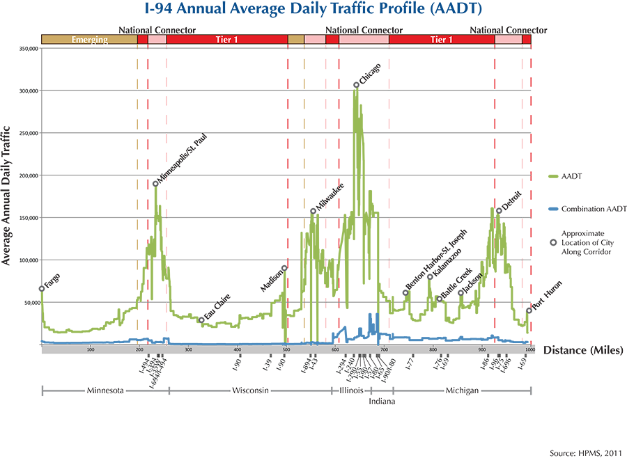
Truck Traffic
I-94 is a 1,010-mile corridor that crosses five states in the MAFC: Minnesota, Wisconsin, Illinois, Indiana, and Michigan.
- VMT 2007: 57,312,782
- Truck VMT 2007: 10,711,496
- Percent Truck VMT: 18.7 percent
Operational Efficiency (ITS)
A large number of message boards (111) and cameras (219) are found along the I-94 corridor, of which there is a strong clustering around urban areas, with 84 percent (93) of message boards and 79 percent (219) of cameras located within the boundaries of major cities in the portion of the interstate running through the MAFC. The large concentrations of message boards are found in Minneapolis (41), Detroit, and Milwaukee (14). With regards to cameras, the greatest concentration is found in Milwaukee (111) and Detroit (93).
Minnesota, Wisconsin, and Michigan have individual memberships to ITS America, whereas Illinois and Indiana collaborate with Kentucky and Ohio through IT Midwest. Additionally, the Minnesota, Illinois, and Michigan DOTs participate in the ENTERPRISE Pool Fund Study.
Greenhouse Gas Emissions
- Yearly tons of CO2 assuming 4 mpg: 4,200,000
- Yearly tons of CO2 assuming 7.5 mpg: 2,200,000
Methodology
- Data: Truck Counts (HPMS 2011)
- Assume 4 and 7.5 miles per gallon
- No control for level of service or elevation changes
- 22.3 lbs. of CO2 per gallon of diesel
Fuel and Truck Parking
| There are 91 fueling stops that also offer truck parking along I-94. Eighteen truck stops have less than 25 parking spots, 33 have between 25-84 spots, and 40 have 85+ parking spots. Compressed Natural Gas (CNG) and Liquified Natural Gas (LNG) stations are listed to the right. | I-94 | CNG | LNG |
| Public | 14 | 0 | |
| Private | 13 | 0 | |
| Planned | 2 | 3 | |
| Total | 29 | 3 |
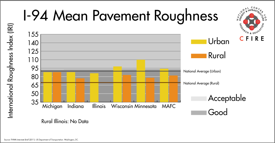
Infrastructure Condition
The International Roughness Index (IRI) measures the cumulative amount of vertical deviation (the bumpiness or roughness) for each segment of road and is reported as a ratio in inches per mile. IRI values less than 95 are generally considered good, while values between 95 and 170 are generally considered acceptable. Since only corridor segments with reported IRI values from the 2011 HPMS dataset were considered in this analysis, some states may be missing from certain corridors.
The IRI is used as a measurement to determine infrastructure conditions within the Highway Performance Monitoring System (HPMS) such as pavement deterioration, pavement condition trends, cost allocation studies, and other analytical purposes. It is reported, at a minimum, for all road segments that fall under the Full Extent classification which includes the National Highway System (NHS), all principal arterials (interstates, freeways, and expressways), and rural minor arterials within the Sample Panel dataset. The data is collected by the states and submitted to the FHWA. The FHWA verifies the data and houses it within the HPMS. For more historical information, see MnDOT’s Introduction to the International Roughness Index.
Freight Facilities
Intermodal Terminals
- Union Pacific (UP) Yard Center Dolton, IL: (<300,000 lifts/yr.)
- Intermodal Service from MN
- Chippewa Falls (30k lifts/per year)
- CSX Bedford Park, IL: TOFC-COFC (294)
- BNSF Willow Springs, Hodgkins, IL: TOFC-COFC (<60,000 lifts/yr.)
Major Rail Yards
- Illinois: Barr, Calumet, Chicago 47th St., Global I, Markham, Yard Center
- Michigan: East, Jackson, Livernois, Melvindale, Port Huron, Rougemere
- Minnesota: Dilsworth, Northtown, Shoreham, Union Wisconsin: Muskego
Airports
- Chicago O’Hare International (ORD)
- Minneapolis – St. Paul International (MSP)
- Detroit Metropolitan Wayne County (DTW)
- General Mitchell International (MKE)
- Willow Run (YIP)
- Hector International (FAR)
Ports
- Port of Detroit
- Port of Indiana – Burns Harbor
- Port of Gary
- Port of Chicago
- Port of Milwaukee
- Port of Minneapolis – St. Paul
Automotive Distribution Centers
- BNSF Minnesota Dilworth
- BNSF Dayton’s Bluff: St. Paul
- CN Markham Yard: Harvey, IL
- Chicago- Chicago Mixing Center (NS)
- Melvindale, MI-(NS)
- Detroit-Huber Yard (NS)
- Dearborn, MI (CN)
Freight Rail
Several segments of the I-94 corridor have parallel lines: St. Paul to Portage, WI, Milwaukee to Chicago, Chicago to Hartford, MI and Kalamazoo to Detroit.
Emerging Intermodal
Although the intermodal terminal in Arcadia, WI is small in comparison to other facilities, it is a destination where containers can be backloaded with products from the rural parts of the Midwest.
Passenger Rail
All Amtrak trains are hubbed out of Union Station in Chicago therefore, the Midwest trains all are connected to the I-94 corridor. This is also a multimodal corridor.
The Amtrak routes in the 1-94 Corridor are: the Empire Builder (Chicago-Milwaukee-Minneapolis-Seattle) short segment around Minneapolis/St. Paul, Tomah-Wisconsin Dells and from Waukesha County to Chicago Union Station; Hiawatha (Chicago-Milwaukee); the Wolverine, Detroit-Chicago. All these routes have been designated as high-speed routes with the Detroit-Chicago segment currently being upgraded.
Airports
There are six air cargo airports that service the I-94 corridor.
- ORD in Chicago is the 3rd ranked air cargo airport in the MAFC region and ranked 6th nationally in terms of 2012 landed cargo weight. UPS and FedEx air cargo facilities are both present at ORD.
- MSP in Minneapolis, DTW in Detroit, MKE in Milwaukee, YIP in Detroit, and FAR in Fargo ranked 5th, 8th, 9th, 17th, and 27th within the MAFC region respectively, and 24th, 35th, 45th, 83rd, and 119th nationally. All but YIP are considered to be primary hub airports. UPS and FedEx Express have air cargo facilities at ORD, MSP, DTW, and MKE.
| Chicago O’Hare International (ORD) |
Minneapolis-St Paul International (MSP) |
Detroit Metropolitan Wayne County (DTW) |
General Mitchell International (MKE) |
Willow Run (YIP) | Hector International (FAR) |
|
| Cargo Facilities | Mechanical Handling, Heated Storage, Air-Conditioned Storage, Refrigerated Storage, Deep Freeze Storage, Mortuary, Animal Quarantine, Fresh Meat Inspection, Health Officials, X-Ray Equipment, Decompression Chamber, Security for Valuables, Dangerous Goods, Radioactive Goods, Very Large/Heavy Cargo, Express/Courier Centre Cargo; Handling Agents: Evergreen/EAGLE, Servisair/GlobeGround |
Mortuary | Mechanical Handling, Heated Storage, Air-Conditioned Storage; Cargo Handling Agents: Evergreen/EAGLE |
Warehouse 6 000m² (64 583sq ft), Aircraft Maintenance, Very Large/Heavy Cargo, Property available for additional cargo facilities, Handling Equipment: K-Loader, Large forklift | ||
| Cargo Terminals | 15 | 1 | 2 | 1 | ||
| Number of Runways (max. length) | 5 (12,998 feet) | 4 (11,007 feet) | 5 (12,004 feet) | 5 (9,691 feet) | 5 (7,526 feet) | 3 (8,999 feet) |
| Warehouses & DCs within 5/10 miles | 27 / 56 | 11 / 58 | 10 / 30 | 7 / 24 | 3 / 19 | 3 / 7 |
| Air Cargo Businesses within Urban Area | 3,339 | 1,303 | 2,324 | 809 | 2,324 | 68 |
| 2011 Landed Weight (lbs.) | 4,368,420,500 | 968,650,986 | 602,804,150 | 490,424,335 | 246,739,675 | 26,450,900 |
| 2010 Landed Weight (lbs.) | 4,895,940,100 | 1,024,128,613 | 552,232,440 | 495,159,556 | 188,203,708 | 21,452,400 |
| Change (Percentage) | -10.77% | -5.42% | 9.16% | -0.96% | 31.10% | 23.30% |
| Intermodal Connectors (5/10 miles) | 7 / 28 | 1 / 1 | 6 / 11 | 21 / 59 | 4 / 15 | 0 / 0 |
Ports
The proposed M-94 (Upper Mississippi River), together with the Illinois River portion of M-55, is the proposed inland Marine Highway reliever route for I-94 between Minneapolis, MN and the ports of southern Lake Michigan (Milwaukee, WI; Chicago, IL; Gary, IN; Burns Harbor, IL; etc.). River ports along the route include St. Louis; MO, Peoria, IL; Joliet, IL; and numerous other small ports and terminals. M-94 also connects to the rest of in inland Marine Highway system. Alternatively, M-90, which connects all four upper Great Lakes, provides a potential Great Lakes Marine Highway reliever route between ports in Detroit, southern Lake Michigan and Minneapolis via the Great Lakes, although the last destination would require a land connection to Duluth, MN. The southern Lake Michigan ports on M-90 provide more direct connections between those port communities than highways or rail and are particularly promising as short sea shipping routes that could bypass the most congested portions of I-94.

Freight Generators, Warehouses, and Distribution Centers
There are a total of 89,142 freight generators employing 1,428,129 people within three miles of the I-94 corridor, and a total of 177,146 freight generators employing 2,877,245 people within 10 miles of the corridor. If the extent of analysis focuses on the metropolitan statistical areas (MSAs) intersected by the I-94 corridor, there are a total of 257,203 freight generators employing 4,120,456 people. Within the MSAs, there are a total of 853 warehousing and distribution centers employing 16,317 people. Freight generators were determined by using the NAICS codes prescribed for freight-related sectors in NCFRP Report 19, and include agriculture, mining, manufacturing, wholesale trade, retail trade, transportation and warehousing, and eating & drinking places.
Major Manufacturers |
Major Distribution Centers |
|
|
References
- FHWA Interstate Brief (2011). US Department of Transportation.