DRAFT
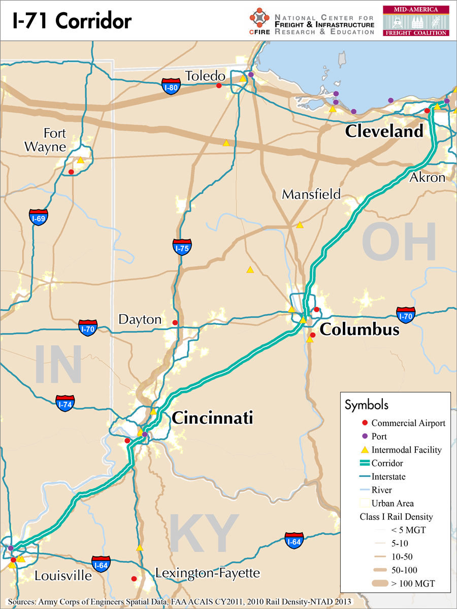
Louisville, Kentucky to Cleveland, Ohio
Snapshot: Length: 344 miles | Length in MAFC: 344 miles | Intersecting Interstates: I-64, I-65, I-70, I-75, I-76, I-80, I-90
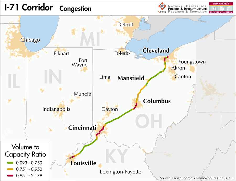
I-71 is an important highway corridor running from Louisville, KY to Cleveland, OH and serving all three of Ohio’s largest population centers. Cleveland, at one end of I-71’s extent, is the 29th largest Metropolitan Statistical Area in the nation, Columbus is 32nd, and Cincinnati is 28th. I-71 also connects to Louisville, which is the 43rd largest city in the nation and an important regional center. While it is designated as a north-south highway, it is also vital to the east-west movement of goods and people across the country. Its entire extent is contained within the MAFC region, but important connections to I-90, I-80, I-76, I-70 and I-64, as well as I-40 via I-65 south of Louisville all make I-71 an essential freight route.
Because of its significant role in connecting four major regional centers of commerce and industry and its importance in north-south and in east-west transportation, the MAFC regional freight study considers I-71 a Tier I freight corridor. With the construction of the Rickenbacker Intermodal Terminal as part of the Heartland Corridor project, freight traffic can be expected to increase further on both I-70 and I-71. The reconstruction of the Jeremiah Morrow Bridge along the segment between Cincinnati and Columbus will also allow additional overweight loads along I-71 which previously would have to be diverted around the Little Miami River.
I-71 is not tolled at any time over its route from Louisville to Cleveland, although it does intersect the Ohio Turnpike as it passes through Cleveland.
Utilizing some of the regional or shortline railways between Cincinnati and Columbus, rail routes are available along this corridor through both CSX and Norfolk Southern. These routes are not as direct when compared with I-71. There are no parallel water routes along the I-71 corridor.
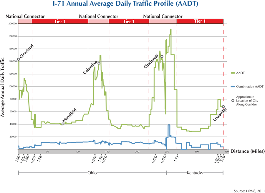
After leaving Louisville, I-71 passes through Worthington, Buckner, La Grange and Pendleton in Kentucky as it heads north towards Cincinnati. Before entering Ohio it also passes through Walton, Florence and Covington, after which it enters downtown Cincinnati. Passing through numerous suburbs and exurbs, including Kenwood, Highpoint, Landen and South Lebanon, I-71 continues northwest across Ohio to Columbus. Between Columbus and its destination in Cleveland, I-71 passes the communities of Mansfield, Ashland, Medina, Brunswick, Strongsville, and Middleburg Heights, before entering the Cleveland metro area where it terminates at an interchange with I-90 and I-490.
Metropolitan Statistical Areas Economic Profile
| MSA | Population | GDP (2011, in millions) | Employment | Freight-related Employment | Metropolitan Planning Organizations |
| Cleveland (OH) | 2,077,240 | $106,810 | 1,095,636 | 427,398 | Northeast Ohio Areawide Coordinating Agency |
| Mansfield (OH) | 124,475 | $3,580 | 60,453 | 29,947 | Richland County Regional Planning Commission |
| Columbus (OH) | 1,901,974 | $93,986 | 994,759 | 344,671 | Mid-Ohio Regional Planning Commission |
| Dayton (OH) | 799,232 | $33,915 | 414,916 | 159,460 | Miami Valley Regional Planning Commission |
| Cincinnati (OH-IN-KY) | 2,114,580 | $102,469 | 1,045,722 | 441,210 | Ohio-Kentucky-Indiana Regional Council of Governments |
| Louisville (KY-IN) | 1,235,708 | $5,588 | 46,893 | 18,573 | Kentuckiana Regional Planning and Development Agency |
National Connectors
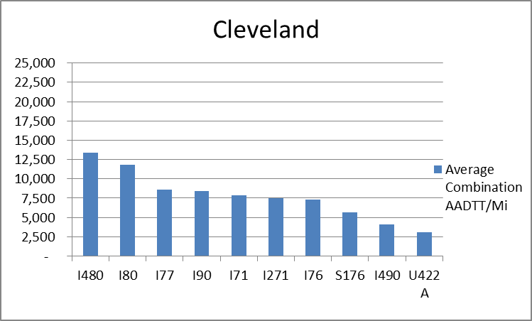
Cleveland, OH
The interstates supporting freight originating in, destined for, and traveling through Cleveland include I-90, I-80, I-76, and I-71. In total, Cleveland has 21 urban interstates, freeways, and expressways that support freight movements. 33.1 percent of combination truck miles traveled on urban interstates, freeways, and expressways in Cleveland are on I-80 and I-480. Additionally, I-480 and I-80 are ranked number one and two based on average combination AADTT per mile respectively.
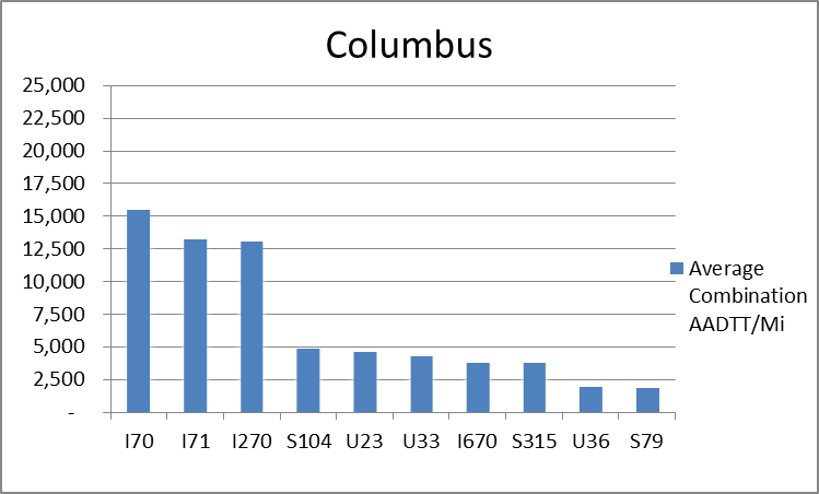
Columbus, OH
The interstates supporting freight originating in, destined for, and traveling through Columbus include I-70 and I-71. In total, Columbus has 17 urban interstates, freeways, and expressways that support freight movements. I-70 and I-71 are first and second respectively based on the average combination AADTT per mile. Furthermore, I-70 and I-71 transport 65.3 percent of combination truck miles on urban interstates, freeways, and expressways in Columbus.
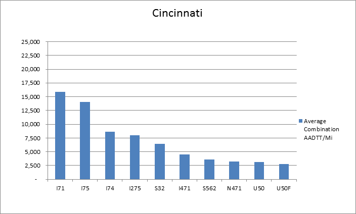
Cincinnati, OH
The interstates supporting freight originating in, destined for, and traveling through Cincinnati include I-71, I-75, and I-74. In total, Cincinnati has 22 urban interstates, freeways, and expressways that support freight movements. I-71, I-74, and I-75 transport 70.0 percent of combination truck miles within Cincinnati and are the top three roadways based on average combination AADTT per mile.
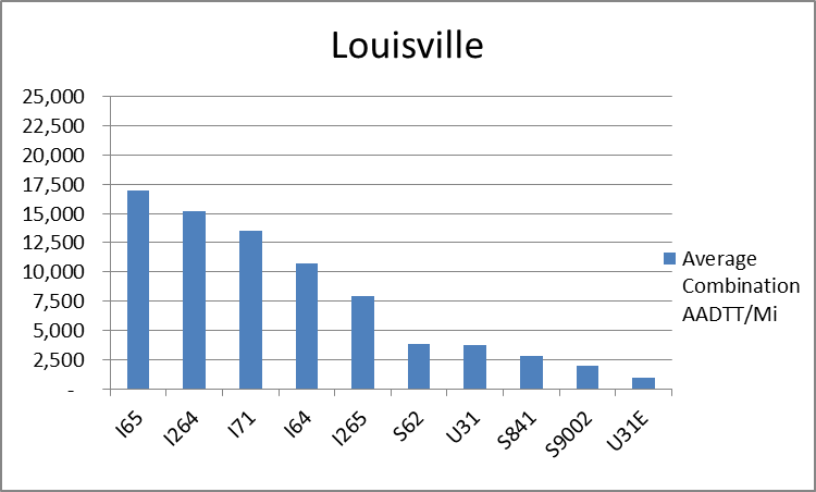
Louisville, KY
The roadway supporting freight originating in, destined for, and traveling through Louisville include I-64, I-65, and I-71. In total, Louisville has 11 urban interstates, freeways, and expressways that support freight movements. I-65, I-71, and I-64 rank first, third, and fourth respectively based on of the average combination AADTT per mile. Furthermore, I-64, I-65, and I-71 transport 76.7 percent of combination truck miles on urban interstates, freeways, and expressways within Louisville.
Freight Projects Impacting Truck Traffic
- Between Columbus and Cincinnati, the Jeremiah Morrow Bridge Replacement Project will replace the outdated bridge with a new structure capable of supporting vehicles over 120,000 pounds so that overweight vehicles that currently exceed the maximum weight capacity of the bridge will no longer need to be diverted around it.
- Additionally, the Ohio River Bridges Project in Kentucky and Indiana includes a major reconstruction of the I-64/I-65/I-71 interchange in downtown Louisville which should significantly reduce the congestion impacting both freight and passenger travel in the corridor where I-71 begins.
Truck Traffic
I-71 is a 344 mile corridor that passes through two MAFC states: Ohio and Kentucky.
- VMT 2007: 20,534,413
- Truck VMT 2007: 4,385,072
- Percent Truck VMT: 21.4 percent
Operational Efficiency (ITS)
Both message boards and cameras are found throughout the I-71 corridor, where they are largely found in urban areas. Of the 24 message boards and 115 cameras found along the interstate highway, the greatest concentrations are seen in Cincinnati (15 message boards and 58 cameras), however smaller clusters of message boards/cameras are also found in Cleveland (3/20) and Columbus (4/24).
Ohio and Kentucky collaborate with Illinois and Indiana through ITS Midwest.
Greenhouse Gas Emissions
- Yearly tons of CO2 assuming 4 mpg: 3,100,000
- Yearly tons of CO2 assuming 7.5 mpg: 1,700,000
Methodology
- Data: Truck Counts (HPMS 2011)
- Assume 4 and 7.5 miles per gallon
- No control for level of service or elevation changes
- 22.3 lbs. of CO2 per gallon of diesel
Fuel and Truck Parking
| There are 20 fueling stations along I-71 that also offer truck parking. Four fueling stations have less than 25 truck parking spaces, three have between 25 and 84 truck parking spaces, and 13 have 85+ truck parking spaces. Compressed Natural Gas (CNG) and Liquefied Natural Gas (LNG) stations are listed to the right. | I-71 | CNG | LNG |
| Public | 1 | 1 | |
| Private | 0 | 0 | |
| Planned | 0 | 0 | |
| Total | 1 | 1 |
Infrastructure Condition
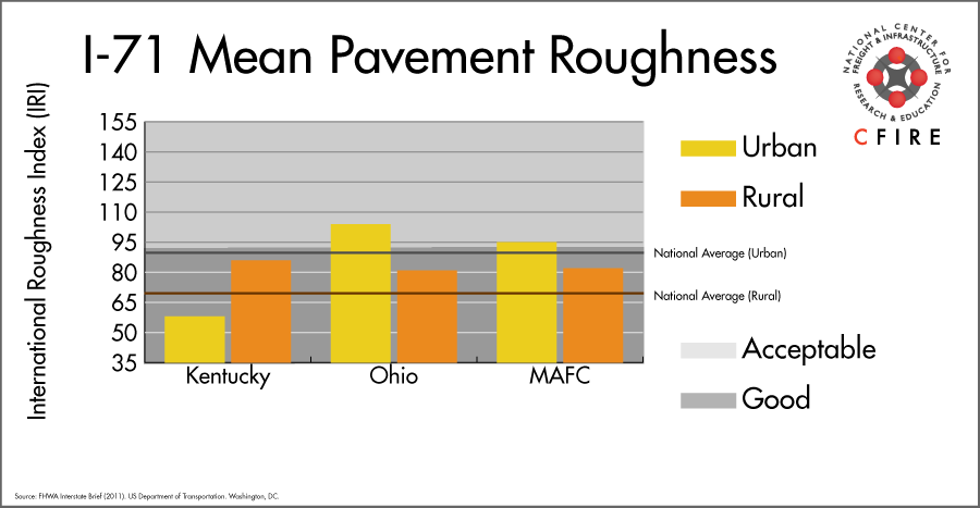
The International Roughness Index (IRI) measures the cumulative amount of vertical deviation (the bumpiness or roughness) for each segment of road, and is reported as a ratio in inches per mile. IRI values less than 95 are generally considered good, while values between 95 and 170 are generally considered acceptable. Since only corridor segments with reported IRI values from the 2011 HPMS dataset were considered in this analysis, some states may be missing from certain corridors.
The IRI is used as a measurement to determine infrastructure conditions within the Highway Performance Monitoring System (HPMS) such as pavement deterioration, pavement condition trends, cost allocation studies, and other analytical purposes. It is reported, at a minimum, for all road segments that fall under the Full Extent classification which includes the National Highway System (NHS), all principal arterials (interstates, freeways, and expressways), and rural minor arterials within the Sample Panel dataset. The data is collected by the states and submitted to the FHWA. The FHWA verifies the data, and houses it within the HPMS. For more historical information, see MnDOT’s Introduction to the International Roughness Index.
Freight Facilities
Intermodal Terminals
- CSX Queensgate Cincinnati: TOFC-COFC (<50,000 lifts/yr.)
- Norfolk Southern (NS) Cincinnati-Gest: TOFC-COFC ( <100,000 lifts/yr.)
- Bluegrass Farms Central Ohio Logistics, Jefferson, OH
Major Rail Yards
- Osborn Yard: Louisville
- Queensgate, Gest: Cincinnati
- Parsons Yard: Columbus
- Rockport, Campbell, Marcy: Cleveland
Airports
- Louisville International – Standiford Field (SDF)
- Cincinnati/Northern Kentucky International (CVG)
- Rickenbacker International (LCK)
- Cleveland-Hopkins International (CLE)
Ports
- Port of Cleveland
- Port of Cincinnati
- Port of Louisville
- Port of Indiana – Jeffersonville
Automotive Distribution Centers
- Louisville- KTP/LAP/Strawberry Yard
Freight Rail
From Cincinnati to Louisville, the CSX has a medium density (10-50 million gross tons-MGT) line that parallels I-71. No freight rail segments are within the I-71 corridor between Cincinnati and Cleveland. Several high-density corridors cross the I-71 corridor: the CSX Cleveland Short Line Subdivision carries over 100 MGT; the National Gateway Corridor in Cleveland and Newcastle carries 50-100 MGT; the Heartland Corridor crosses this corridor in Columbus and Cincinnati carrying over 100 MGT a year (1).
Emerging Intermodal
Two freight rail projects in the outskirts of Columbus will impact freight flows throughout the region and have changed the functions of some older yards. The first is CSX’s National Gateway project, which is a multi-state public-private partnership between the Mid-Atlantic states, and the Midwest to clear freight corridors for doublestack moves from east coast ports. The Midwest service is hubbed in New Baltimore, Ohio at the Northwest Ohio Intermodal Container Terminal Facility (NW Ohio ICTF), a facility that has a capacity of 2 million lifts per year. One of the spokes’ termini is the recently expanded Buckeye Yard outside Columbus (from 180,000 lift capacity to 360,000 lifts per year). Trains arrive from east coast ports to New Baltimore where they are re-assembled and sent to other yards. During the recent Buckeye Yard expansion, intermodal domestic containers were moved to Marion, Ohio.
South of Columbus, the Norfolk Southern operates the Rickenbacker Intermodal Terminal. Built in 2008, the facility has capacity for 400,000 lifts per year and can accommodate TOFC-COFC moves. This facility is part of the south-north Heartland Corridor, the strategic public-private partnership to move trains faster from the Port of Norfolk, VA to Columbus, Detroit, and Chicago. The project consisted of improving clearances to accommodate double stack and improving line capacities reducing transit times from the East Coast by one day.
The Heartland Corridor was recently expanded from Columbus to Cincinnati (Sharonville) as an intermodal/automotive corridor. While this corridor is outside the I-71 truck corridor, the new service may reduce trucks moving containers between Columbus and Cincinnati over I-71.
The Central Logistics Center in Jeffersonville, OH has been developed as a response to the need to export identity preserved beans and non-genetically modified crops. Bluegrass Farms is the owner of the facility. Heavy containers are moved to the Queensgate Terminal by shortline where they are placed on a barge.
Passenger Rail
The Cardinal/Hoosier State service (New York-Washington DC-Cincinnati-Indianapolis-Chicago) operating over the CSX railroad intersects the I-71 corridor with a station in Cincinnati. The CSX line also carries more than 100 million gross tons (MGT). In Cleveland, a short segment follows the I-71 corridor. Two services, Capitol Limited (Washington, DC-Pittsburgh-Cleveland-Chicago) and the Lake Shore Limited (New York-Boston-Albany-Chicago) operate over 36 miles in the I-71 corridor.
Airports
There are 4 air cargo airports that service the I-71 corridor.
- SDF in Louisville, KY was the top-ranked commercial airport in the MAFC region in terms of landed weight in 2012. Nationally it ranked 3rd after Memphis, TN and Anchorage, AK. SDF is considered a primary hub airport, is home to UPS Worldport, and is serviced by FedEx Express.
- CVG in northern Kentucky (Cincinnati) is the 4th busiest airport in terms of landed weight in 2012 within the MAFC region and ranked 9th nationally. It is considered a primary hub airport, and is serviced by both UPS and FedEx Express.
- LCK in Columbus and CLE in Cleveland ranked 7th and 13th, respectively in the MAFC region in terms of landed weight in 2012. Nationally the two ranked 33rd and 59th, and both offer UPS and FedEx Express services.
| Louisville International-Standiford Field (SDF) | Cincinnati/Northern Kentucky International (CVG) | Rickenbacker International (LCK) | Cleveland-Hopkins International (CLE) | |
| Cargo Facilities | Domestic Cargo Only, Mechanical Handling, Heated Storage, Dangerous Goods, Express/Courier Centre, Parking space for large transient aircraft is very limited. | Bonded Warehouse, Mechanical Handling, Heated Storage, Air-Conditioned Storage, Security for Valuables, Very Large/Heavy Cargo, Express/Courier Centre | Bonded Warehouse, Free Port/Foreign Trade Zone, Aircraft Maintenance, Dangerous Goods, Very Large/Heavy Cargo; Cargo Handling Agents: Evergreen/EAGLE | Bonded Warehouse, Mechanical Handling, Heated Storage, Livestock Handling, Security for Valuables, Dangerous Goods, Radioactive Goods, Very Large/Heavy Cargo, Express/Courier Centre, Handling Equipment: K loader 20,000 lbs forklift, freight dolly; Cargo Handling Agents: Servisair/GlobeGround |
| Cargo Terminals | 1 | n/a | n/a | 1 |
| Number of Runways (max. length) | 3 (10,849 feet) | 4 (12,001 feet) | 2 (12,103 feet) | 4 (8,999 feet) |
| Warehouses & DCs within 5/10 miles | 19 / 48 | 18 / 54 | 6 / 29 | 15 / 24 |
| Air Cargo Businesses within Urban Area | 283 | 706 | 459 | 1,180 |
| 2011 Landed Weight (lbs.) | 10,981,281,067 | 2,819,377,048 | 653,902,306 | 369,077,012 |
| 2010 Landed Weight (lbs.) | 10,637,700,120 | 2,431,870,514 | 683,430,047 | 380,855,675 |
| Change (Percentage) | 3.23% | 15.93% | -4.32% | -3.09% |
| Intermodal Connectors (5/10 miles) | 4 / 11 | 3 / 22 | 3 / 3 | 16 / 29 |
Ports and Marine Highways
M-71/M-77 Marine Highway crossings in and around Cleveland, OH provide a maritime route to Canada but are also intended to provide a maritime alternative for connecting I-71, I-77, and other arterial highways near Cleveland. At the south end of I-71, M-70 provides a potential Marine Highway reliever route to I-71 between Cincinnati, OH and Louisville, KY on the Ohio River.
Freight moving on I-71 between Cleveland and the Ohio River could be shipped on the Ohio River (M-70) as far as Pittsburgh, PA then overland to Lake Erie ports (M-90) but this would be very indirect, and require transit mode changes and transit through another congested metropolitan area.

Freight Generators, Warehouses, and Distribution Centers
There are a total of 29,613 freight generators employing 509,519 people within three miles of the I-71 corridor, and a total of 64,945 freight generators employing 1,155,404 people within 10 miles of the corridor. If the extent of analysis focuses on the metropolitan statistical areas (MSAs) intersected by the I-71 corridor, there are a total of 118,947 freight generators employing 1,924,205 people. Within the MSAs, there are a total of 549 warehousing and distribution centers employing 10,885 people.
Freight generators were determined by using the NAICS codes prescribed for freight-related sectors in NCFRP Report 19, and include agriculture, mining, manufacturing, wholesale trade, retail trade, transportation and warehousing, and eating and drinking places.
Major Manufacturers |
Major Distribution Centers |
|
|
References
- National Transportation Atlas Database (2013). Bureau of Transportation Statistics. US Department of Transportation. Washington, DC.
- FHWA Interstate Brief (2011). US Department of Transportation.