DRAFT
Columbia, South Carolina to Cleveland, Ohio
Snapshot: Length: 610 miles | Length in MAFC: 163 miles | Intersecting Interstates: I-20, I-26, I-40, I-64, I-70, I-74, I-76, I-80, I-81, I-85, I-90
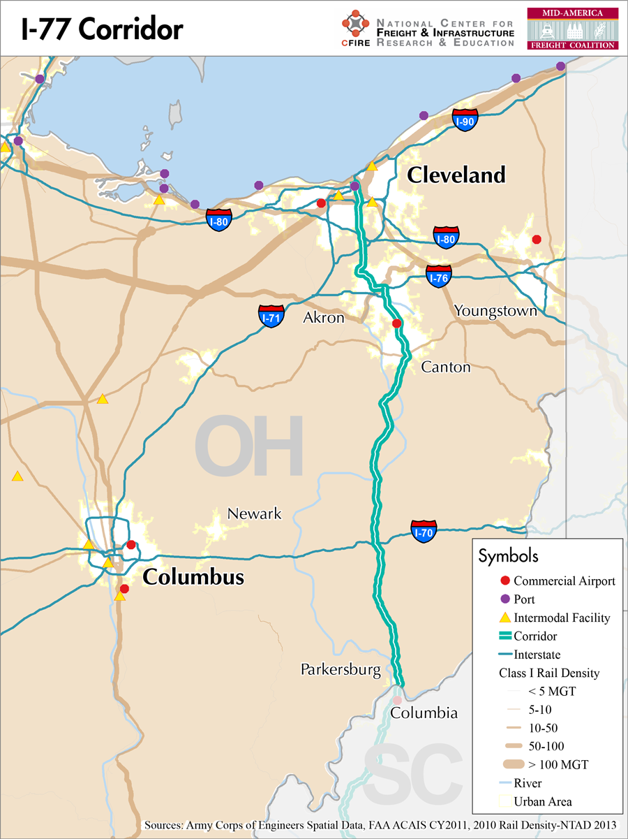
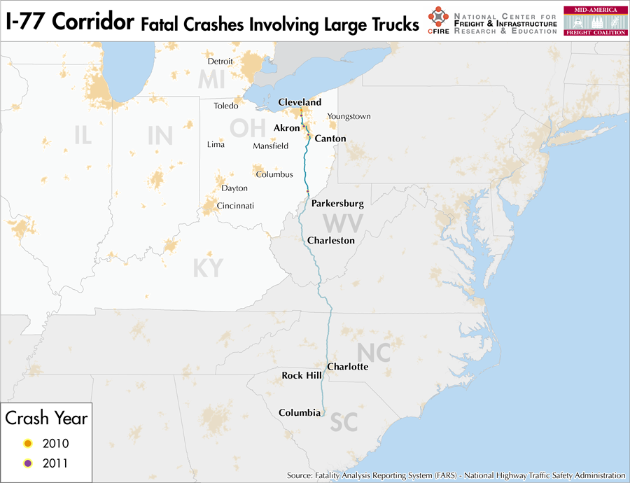
I-77’s southern terminus can be found in Columbia, South Carolina where it heads north through North Carolina and West Virginia before entering the MAFC in Ohio. The northern terminus is in Cleveland where it interchanges with I-90. I-77 is an important north-south route through the Appalachians and links a number of important cities within the Great Lakes and Southeast regions. Within Ohio, I-77 is known as the “Vietnam Veterans’ of America Highway.” It has major interchanges with I-70 in Cambridge, OH, with I-76 in Akron, OH and with I-80 (Ohio Turnpike) and I-90 in Cleveland.
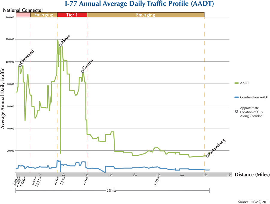
The majority of I-77 is classified as an emerging freight corridor for most of is extent within the MAFC. Heading south from Cleveland, however, all the way down to Canton, OH, the MAFC nationally significant corridor network study qualifies it as Tier one because of high traffic volumes and the larger cities which it connects in this area. Future growth south of Canton, OH will continue to increase the importance of the I-77 corridor as goods move from production centers in the south to production centers within the Great Lakes region. I-77 provides access not only to Cleveland but also to Columbus, Pittsburgh, and Detroit.
There is no point at which I-77 is tolled during its time in Ohio, however, it does intersect the Ohio Turnpike on the south side of Cleveland where I-80 passes through and continues on to become the Pennsylvania turnpike in the east. I-77 is designated at a statewide primary highway corridor south of Canton by Ohio DOT and as a national highway corridor north of Canton, these designations are also manifested in the Access Ohio Strategic Transportation System map.
There is no parallel rail or water freight service along the I-77 corridor. A major reason for this is that the terrain is not conducive to railways, being much too steep and uneven. I-77 does have a companion marine crossing of M-71/77, the Lake Erie Marine highway Crossing. M-71/77 links the Cleveland metro area and the Port Burwell, ON area. The recent improvements related to the Heartland Corridor Project somewhat increase access to West Virginia and southern Ohio but largely serve as an east-west route rather than a north-south route. Because of the nearly complete absence of comparable intermodal capacity, I-77 is essential for moving goods north across the Appalachians.
Though there are no real parallel rail options for freight traveling on I-77, it does have connections to rail facilities through Cleveland, OH. The Cleveland rail corridor is quite congested with many rail lines of varying degrees of densities, the highest being the CSX Cleveland Short Line Subdivision with volumes greater than 100 million gross tons (MGT), followed by Norfolk Southern’s Cleveland Line Subdivision with volumes between 50 and 100 MGT. Outside of Cleveland, a number of shortlines, including excursion rail or very light density Class I lines operate.
Outside the MAFC, I-77 serves Columbia, SC, Rockhill, SC, Charlotte, NC, Charleston, WV and Parkersburg, WV. Once I-77 enters Ohio it passes Marietta at the border, then Cambridge, Dover, Canton and Akron and finally enters Cleveland.
Metropolitan Statistical Areas Economic Profile
| MSA | Population | GDP (2011, in millions) | Employment | Freight-related Employment | Metropolitan Planning Organizations |
| Cleveland (OH) | 2,077,240 | $106,810 | 1,095,636 | 427,398 | Northeast Ohio Areawide Coordinating Agency |
| Akron (OH) | 703,200 | $28,053 | 335,393 | 150,312 | Akron Metropolitan Area Transportation Study |
| Canton-Massillon (OH) | 404,422 | $13,193 | 204,844 | 91,301 | Stark County Regional Planning Commission |
| Parkersburg-Marietta (WV-OH) | 92,673 | $5,619 | 70,209 | 32,033 | Wood-Washington-Wirt Interstate Planning Commission |
National Connectors
Cleveland, OH
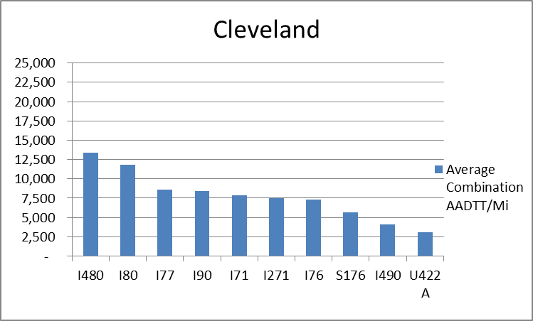
The interstates supporting freight originating in, destined for, and traveling through Cleveland include I-90, I-80, I-76, and I-71. In total, Cleveland has 21 urban interstates, freeways, and expressways that support freight movements. 33.1 percent of combination truck miles traveled on urban interstates, freeways, and expressways in Cleveland are on I-80 and I-480. Additionally, I-480 and I-80 are ranked first and second based on average combination AADTT per mile, respectively.
Freight Projects Impacting Truck Traffic
The projects currently being carried out on I-77 in Ohio appear to be mostly routine maintenance of the corridor.
Truck Traffic
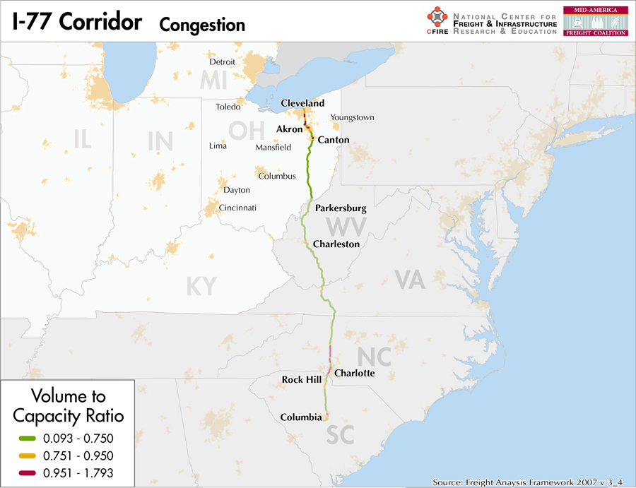
I-77 is a 163 mile corridor that passes through one MAFC state: Ohio.
- VMT 2007: 6,800,380
- Truck VMT 2007: 1,001,182
- Percent Truck VMT: 14.7 percent
Operational Efficiency (ITS)
All of the message boards (12) and cameras (46) along the I-77 corridor are found within the urban areas of Cleveland, Akron, and Columbus. Most of the message boards are found in Akron (7), with 3 additional boards found in both in Cleveland and Columbus. The largest clusters of cameras are found in Cleveland (12) and Akron (12), followed by Columbus (7).
Ohio collaborates with Illinois, Indiana, and Kentucky through ITS Midwest.
Greenhouse Gas Emissions
- Yearly tons of CO2 assuming 4 mpg: 730,000
- Yearly tons of CO2 assuming 7.5 mpg: 390,000
Methodology
- Data: Truck Counts (HPMS 2011)
- Assume 4 and 7.5 miles per gallon
- No control for level of service or elevation changes
- 22.3 lbs. of CO2 per gallon of diesel
Fuel and Truck Parking
| There are 7 fueling stops that also offer truck parking along I-77. One truck stop has less than 25 parking spots, 3 have between 25-84 spots, and 3 have 85+ parking spots. Compressed Natural Gas (CNG) and Liquified Natural Gas (LNG) stations are listed to the right. | I-77 | CNG | LNG |
| Public | 1 | 0 | |
| Private | 1 | 0 | |
| Planned | 0 | 0 | |
| Total | 2 | 0 |
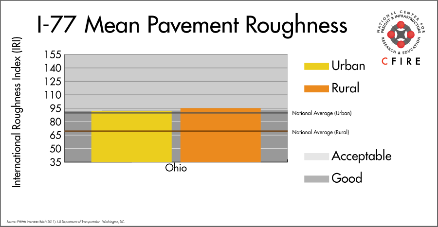
Infrastructure Condition
The International Roughness Index (IRI) measures the cumulative amount of vertical deviation (the bumpiness or roughness) for each segment of road, and is reported as a ratio in inches per mile. IRI values less than 95 are generally considered good, while values between 95 and 170 are generally considered acceptable. Since only corridor segments with reported IRI values from the 2011 HPMS dataset were considered in this analysis, some states may be missing from certain corridors.
The IRI is used as a measurement to determine infrastructure conditions within the Highway Performance Monitoring System (HPMS) such as pavement deterioration, pavement condition trends, cost allocation studies, and other analytical purposes. It is reported, at a minimum, for all road segments that fall under the Full Extent classification which includes the National Highway System (NHS), all principal arterials (interstates, freeways, and expressways), and rural minor arterials within the Sample Panel dataset. The data is collected by the states and submitted to the FHWA. The FHWA verifies the data, and houses it within the HPMS. For more historical information, see MnDOT’s Introduction to the International Roughness Index.
Freight Facilities
Intermodal Terminals
- Norfolk Southern (NS) Cleveland Intermodal Terminal: TOFC-COFC (<100,000 lifts/yr.)
- CSX Collinwood: TOFC-COFC (>100,000 lifts/yr.)
Major Rail Yards
- Cleveland: Campbell, Marcy
Airports
- Cleveland-Hopkins International (CLE)
Ports
- Port of Cleveland
Freight Rail
In Cleveland the corridor is quite congested with many rail lines of varying degrees of densities, the highest being the CSX Cleveland Short Line Subdivision with volumes greater than 100 million gross tons (MGT) according to 2010 rail density data from the 2013 National Transportation Atlas Database. Next in density is the Norfolk Southern’s Cleveland Line Subdivision with volumes between 50 and 100 MGT. Outside of Cleveland, a number of shortlines, including excursion rail or very light density Class I lines operate.
Passenger Rail
There are two Amtrak services that cross the 1-77 corridor. The Cleveland station is located near the 1-77 terminus, west of the intersection with I-90. These services are: Capitol Limited (Washington, DC-Pittsburgh-Cleveland-Chicago) and the Lake Shore Limited (New York/Boston-Albany-Chicago. These are heavy density freight rail (50 to over 100 MGT) routes as well.
Airports
There is one air cargo airport that services the I-77 corridor.
CLE in Cleveland is the 13th ranked commercial airport in the MAFC region in terms of landed weight (2012). Nationally, CLE ranked 59th in 2012. It is considered a primary hub airport, and is serviced by both UPS and FedEx with air cargo facilities.
| Cleveland-Hopkins International (CLE) | |
| Cargo Facilities | Bonded Warehouse, Mechanical Handling, Heated Storage, Livestock Handling, Security for Valuables, Dangerous Goods, Radioactive Goods, Very Large/Heavy Cargo, Express/Courier Centre, Handling Equipment: K loader 20,000 lbs forklift, freight dolly; Cargo Handling Agents: Servisair/GlobeGround |
| Cargo Terminals | 1 |
| Number of Runways (max. length) | 4 (8,999 feet) |
| Warehouses & DCs within 5/10 miles | 15 / 24 |
| Air Cargo Businesses within Urban Area | 1,180 |
| 2011 Landed Weight (lbs.) | 369,077,012 |
| 2010 Landed Weight (lbs.) | 380,855,675 |
| Change (Percentage) | -3.09% |
| Intermodal Connectors (5/10 miles) | 16 / 29 |
Ports
M-71/M-77 Marine Highway crossings in and around Cleveland, OH provide a maritime crossing to Canada but are also intended to provide a maritime alternative for connecting I-77, I-71, and other arterial highways near Cleveland. Freight moving via I-71 between Cleveland and the Ohio River could be shipped via the Ohio River (M-70) as far as Pittsburgh, PA then overland to Lake Erie ports (M-90) but this would be very indirect, and require transit mode changes and transit through another congested metropolitan area.

Freight Generators, Warehouses, and Distribution Centers
There are a total of 12,352 freight generators employing 205,043 people within three miles of the I-77 corridor, and a total of 29,041 freight generators employing 477,027 people within 10 miles of the corridor. If the extent of analysis focuses on the metropolitan statistical areas (MSAs) intersected by the I-77 corridor, there are a total of 42,685 freight generators employing 701,044 people. Within the MSAs, there are a total of 119 warehousing and distribution centers employing 2,234 people. Freight generators were determined by using the NAICS codes prescribed for freight-related sectors in NCFRP Report 19, and include agriculture, mining, manufacturing, wholesale trade, retail trade, transportation and warehousing, and eating and drinking places.
Major Manufacturers |
Major Distribution Centers |
|
|
References
- FHWA Interstate Brief (2011). US Department of Transportation.