DRAFT
Davenport, Iowa to Cincinnati, Ohio
Snapshot: Length: 429 miles | Length in MAFC: 417 miles | Intersecting Interstates: I-55, I-57, I-65, I-70, I-75, I-80
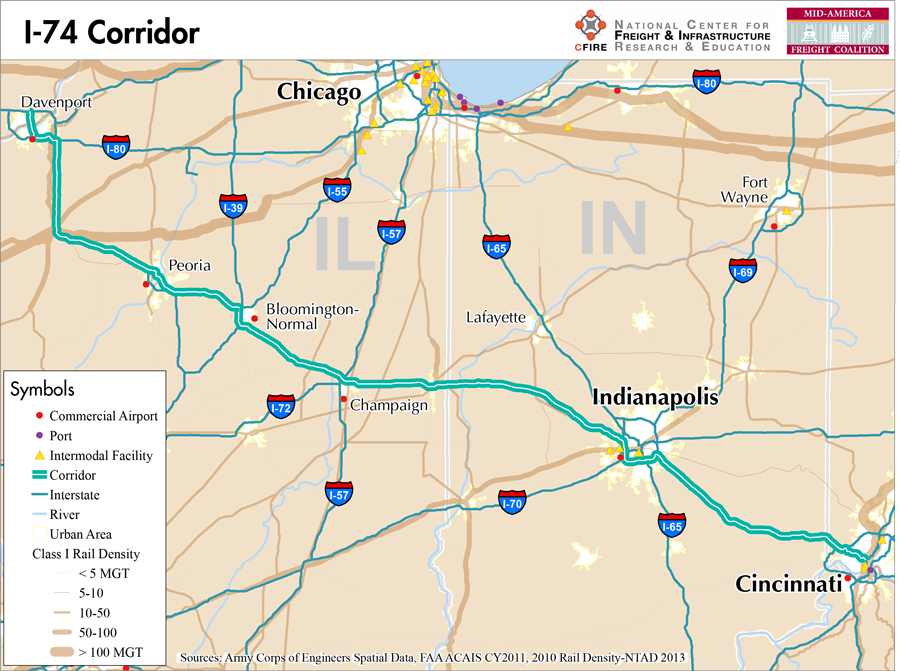
I-74 begins in Davenport, Iowa near the Illinois border at an interchange with I-80. It crosses Illinois and Indiana on a southeastern path before ending in Cincinnati, Ohio. Besides this portion of I-74 that is completely within the MAFC region, there is also a segment of I-74 in North Carolina. There are currently no plans to connect these two segments across Virginia, West Virginia, and Ohio.
I-74 earns its Tier 2 MAFC Nationally Significant Freight Corridor for its role in connecting several important economic centers in the region and greatly reducing the travel time between numerous areas. Interstate 74, through its connections with I-39 in Bloomington-Normal and I-80 in Davenport allows goods from Iowa, Minnesota and Wisconsin to avoid the congested Chicago region when shipping and receiving goods to the eastern states in the MAFC region and beyond.
I-74 is not tolled during any part of its route. It is considered a Designated Truck Route in Illinois and a Commerce Corridor in Indiana.
Although it is possible for freight movement by rail parallel to I-74, there is not a direct route and any trip would need to utilize the lines of at least three railroads. The most efficient route is provided by Norfolk Southern and two of their partner short line railroads. There is not a maritime route which follows the same course as I-74.
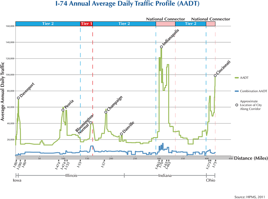
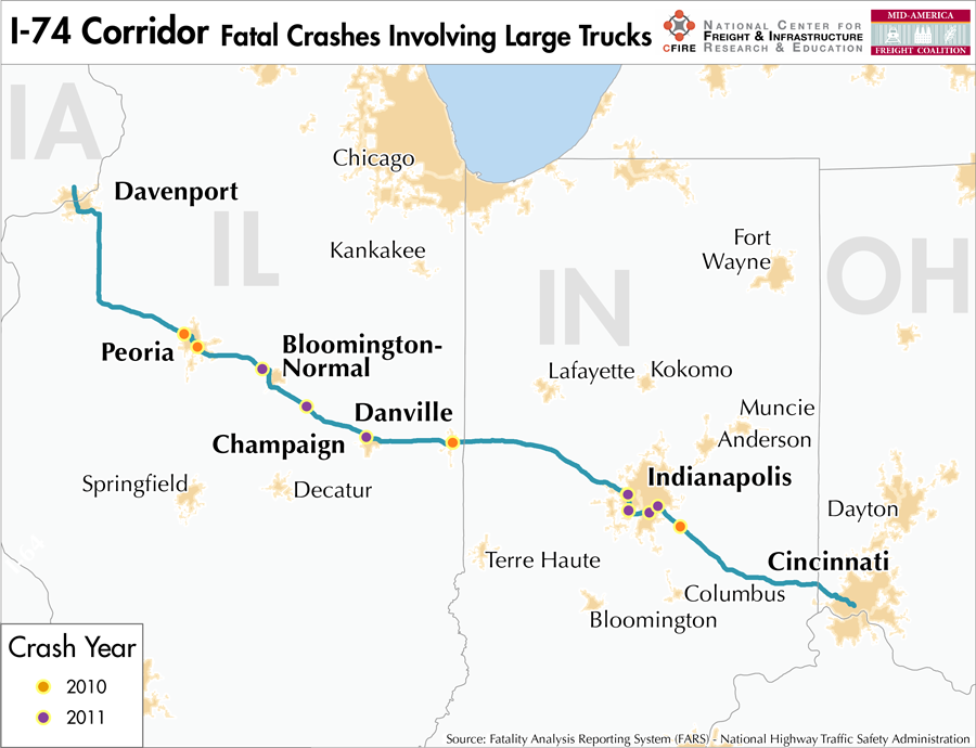
Beginning in Davenport, IA, I-74 crosses the Mississippi into Moline, another of the Quad Cities and then serves Galesburg, Peoria, Bloomington-Normal, Champaign and Danville in Illinois. Indianapolis is its main destination in Indiana before crossing into Ohio and terminating in Cincinnati.
Metropolitan Statistical Areas Economic Profile
| MSA | Population | GDP (2011, in millions) | Employment | Freight-related Employment | Metropolitan Planning Organizations |
| Quad Cities (IL-IA) | 379,690 | $18,311 | 195,502 | 84,353 | Bi-State Regional Commission |
| Peoria (IL) | 379,186 | $20,190 | 182,610 | 65,936 | Peoria/Pekin Urbanized Area Transportation Study |
| Bloomington-Normal (IL) | 169,572 | $9,535 | 112,151 | 26,872 | McLean County Regional Planning Commission |
| Champaign-Urbana (IL) | 231,891 | $9,238 | 109,306 | 38,361 | Champaign Urbana Area Transportation Study |
| Danville (IL) | 81,625 | $2,490 | 32,795 | 16,161 | Danville Area Transportation Study |
| Terre Haute (IN) | 172,425 | $5,817 | 72,202 | 31,408 | West Central Indiana Economic Development District |
| Indianapolis (IN) | 1,887,877 | $103,815 | 925,961 | 323,431 | Indianapolis MPO |
| Cincinnati (OH-IN-KY) | 2,114,580 | $102,469 | 1,045,722 | 441,210 | Ohio-Kentucky-Indiana Regional Council of Governments |
National Connectors
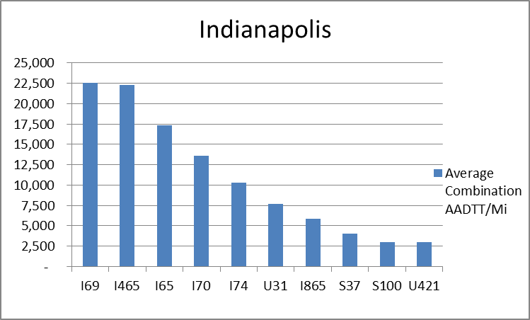
Indianapolis, IN
The interstates supporting freight originating in, destined for, and traveling through Indianapolis include I-74, I-70, I-65, I-70, and I-69. In total, Indianapolis has 12 urban interstates, freeways, and expressways that support freight movements. I-69, I-65, and I-70 rank first, third, and fourth respectively based on of average combination AADTT per mile. Furthermore, I-69, I-65, and I-70 transport 58.5 percent of combination truck miles on urban interstates, freeways, and expressways within Indianapolis.
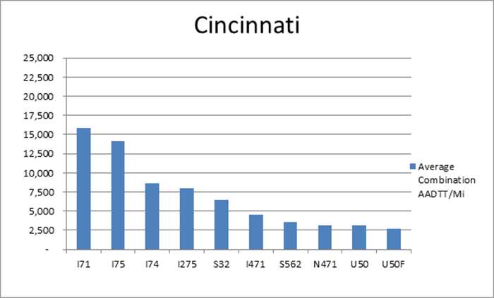
Cincinnati, OH
The interstates supporting freight originating in, destined for, and traveling through Cincinnati include I-71, I-75, and I-74. In total, Cincinnati has 22 urban interstates, freeways, and expressways that support freight movements. I-71, I-74, and I-75 transport 70.0 percent of combination truck miles within Cincinnati and are the top three roadways based on average combination AADTT per mile.
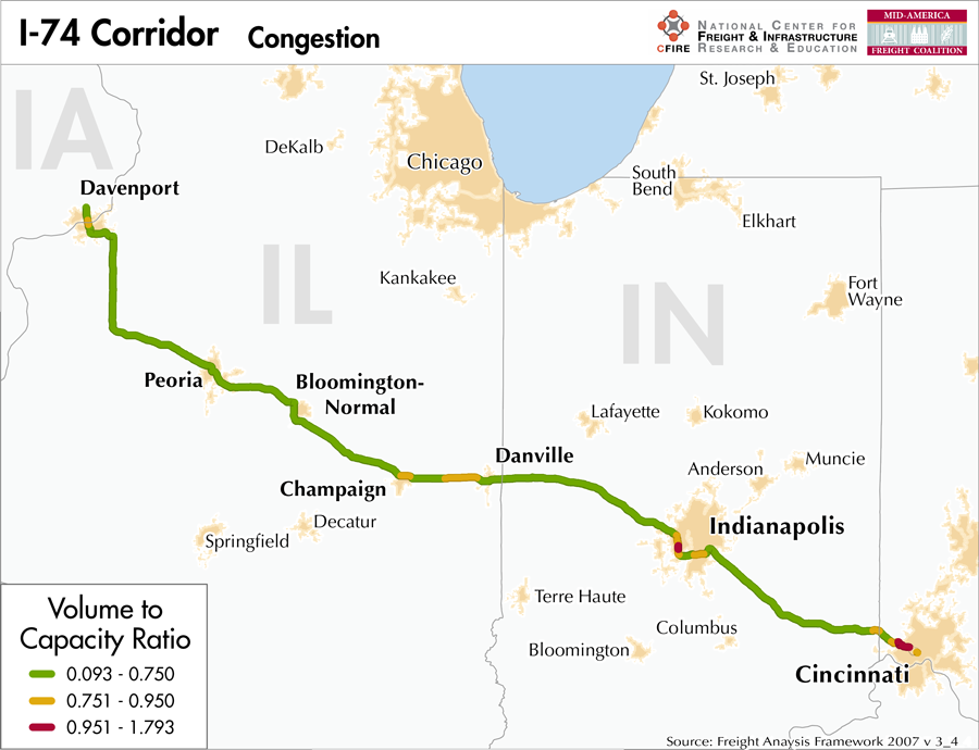
Freight Projects Impacting Truck Traffic
This corridor is not currently undergoing any major projects that will have significant impacts on freight movement. Standard preservation work is being carried out to maintain a good state of repair.
Truck Traffic
I-74 is a 417-mile corridor that crosses four states in the MAFC: Iowa, Illinois, Indiana, and Ohio.
- VMT 2007: 12,155,231
- Truck VMT 2007: 2,963,203
- Percent Truck VMT: 24.4 percent
Operational Efficiency (ITS)
The cameras and message boards found along the I-74 Corridor are largely concentrated on the eastern portion of the interstate, given their sparse existence in Illinois. Cameras are tightly clustered around the urban areas of Indianapolis (34) and Cincinnati (19). The same pattern is largely observed with regards to message boards, although found west of the Illinois-Indiana border (3 in Illinois, 4 in Iowa), the bulk of message boards are found in Indianapolis (10) and Cincinnati (4).
Illinois, Indiana, and Ohio collaborate with Kentucky through ITS Midwest, whereas Iowa works in partnership with Kansas, Missouri, Nebraska, and Oklahoma through ITS Heartland. Additionally, the Iowa and Illinois DOTs participate in the ENTERPRISE Pool Fund Study.
Greenhouse Gas Emissions
- Yearly tons of CO2 assuming 4 mpg: 1,900,000
- Yearly tons of CO2 assuming 7.5 mpg: 1,000,000
Methodology
- Data: Truck Counts (HPMS 2011)
- Assume 4 and 7.5 miles per gallon
- No control for level of service or elevation changes
- 22.3 lbs. of CO2 per gallon of diesel
Fuel and Truck Parking
| There are 27 fueling stops that also offer truck parking along I-74. Ten truck stops have less than 25 parking spots, 6 have between 25-84 spots, and 11 have 85+ parking spots. Compressed Natural Gas (CNG) and Liquified Natural Gas (LNG) stations are listed to the right. | I-74 | CNG | LNG |
| Public | 4 | 0 | |
| Private | 2 | 0 | |
| Planned | 3 | 1 | |
| Total | 9 | 1 |
Infrastructure Condition
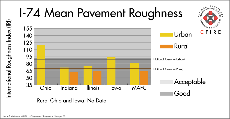
The International Roughness Index (IRI) measures the cumulative amount of vertical deviation (the bumpiness or roughness) for each segment of road, and is reported as a ratio in inches per mile. IRI values less than 95 are generally considered good, while values between 95 and 170 are generally considered acceptable. Since only corridor segments with reported IRI values from the 2011 HPMS dataset were considered in this analysis, some states may be missing from certain corridors.
The IRI is used as a measurement to determine infrastructure conditions within the Highway Performance Monitoring System (HPMS) such as pavement deterioration, pavement condition trends, cost allocation studies, and other analytical purposes. It is reported, at a minimum, for all road segments that fall under the Full Extent classification which includes the National Highway System (NHS), all principal arterials (interstates, freeways, and expressways), and rural minor arterials within the Sample Panel dataset. The data is collected by the states and submitted to the FHWA. The FHWA verifies the data, and houses it within the HPMS. For more historical information, see MnDOT’s Introduction to the International Roughness Index.
Freight Facilities
Intermodal Terminals
- CSX Queensgate Cincinnati: TOFC-COFC (<50,000 lifts/yr.)
- Norfolk Southern (NS) Cincinnati-Gest: TOFC-COFC ( <100,000 lifts/yr.)
Major Rail Yards
- Queensgate, Gest: Cincinnati
Airports
- Indianapolis International (IND)
- Cincinnati/Northern Kentucky International (CVG)
- General Downing – Peoria International (PIA)
Ports
- Port of Cincinnati
Automotive Distribution Centers
- Mitsubishi Motors: Normal, IL (Norfolk Southern)
Freight Rail
A short segment (39 rail miles) of the BNSF Barstow Subdivision runs parallel to the I-74 corridor near Davenport to Galesburg. This segments carries between 50 and 100 million gross tons (MGT) per year (1). Another short segment from Crawfordsville to Indianapolis carries 10-50 MGT within the corridor. Two routes intersect the corridor with densities greater than 100 MGT: BNSF’s TransCon at Galesburg and the CSX Toledo Subdivision at its terminus in Cincinnati.
Passenger Rail
There is no passenger service parallel to I-74.
I-74 crosses 4 north/south Amtrak routes. The stations and services are:
- Galesburg, IL – Southwest Chief, California Zephyr, Illinois Zephyr, and Carl Sandburg
- Bloomington/Normal – Texas Eagle and Lincoln Service
- Champaign, IL – City of New Orleans, Illini and Saluki
- Indianapolis, IN – Cardinal/Hoosier State
Airports
There are three air cargo airports that service the I-74 corridor.
- IND in Indianapolis is the second-ranked airport in the MAFC region and fifth nationally in terms of landed weight (2012). It is considered a primary hub airport, and is serviced with air cargo facilities for both UPS and FedEx Express.
- CVG in northern Kentucky (Cincinnati) and PIA in Peoria are also both considered primary hub airports. CVG is ranked 4th in the MAFC region and 9th nationally, while PIA ranked 20th and 88th, respectively. UPS and FedEx both have air cargo facilities at CVG, while only FedEx services PIA.
| Indianapolis International (IND) | Cincinnati/Northern Kentucky International (CVG) | General Downing – Peoria International (PIA) | |
| Cargo Facilities | Bonded Warehouse, Free Port/Foreign Trade Zone, Aircraft Maintenance, Express/Courier Centre | Bonded Warehouse, Mechanical Handling, Heated Storage, Air-Conditioned Storage, Security for Valuables, Very Large/Heavy Cargo, Express/Courier Centre | 3x 747 Freighter Docks, Bonded Warehouse, Free Port/Foreign Trade Zone, Aircraft Maintenance, Mechanical Handling, Heated Storage, Security for Valuables, Very Large/Heavy Cargo, No other limitations |
| Cargo Terminals | 4 | 2 | |
| Number of Runways (max. length) | 3 (11,200 feet) | 4 (12,001 feet) | 2 (10,104 feet) |
| Warehouses & DCs within 5/10 miles | 16 / 34 | 18 / 54 | 6 / 15 |
| Air Cargo Businesses within Urban Area | 533 | 706 | 96 |
| 2011 Landed Weight (lbs.) | 4,813,314,835 | 2,819,377,048 | 149,632,080 |
| 2010 Landed Weight (lbs.) | 4,717,295,655 | 2,431,870,514 | 183,258,309 |
| Change (Percentage) | 2.04% | 15.93% | -18.35% |
| Intermodal Connectors (5/10 miles) | 8/9 | 3/22 | 3/7 |
Ports
M-70/M-55/M-94 provide a potential Marine Highway reliever route for I-74 between Cincinnati, Ohio, and Bettendorf and Davenport, IA. The Ohio River (M-70) connects to the segment of the Mississippi River between the mouth of the Ohio and the mouth of the Illinois River (M-55/M-70) northward to the Upper Mississippi (M-94) to Bettendorf and Davenport, IA. I-74 runs through Peoria, IL, which along with other Illinois River (M-55) ports, could also reach port communities at either end of I-74.

Freight Generators, Warehouses, and Distribution Centers
There are a total of 16,363 freight generators employing 278,770 people within three miles of the I-74 corridor, and a total of 38,523 freight generators employing 680,974 people within 10 miles of the corridor. If the extent of analysis focuses on the metropolitan statistical areas (MSAs) intersected by the I-74 corridor, there are a total of 60,935 freight generators employing 1,027,732 people. Within the MSAs, there are a total of 562 warehousing and distribution centers employing 12,462 people. Freight generators were determined by using the NAICS codes prescribed for freight-related sectors in NCFRP Report 19, and include agriculture, mining, manufacturing, wholesale trade, retail trade, transportation and warehousing, and eating and drinking places.
Major Manufacturers |
Major Distribution Centers |
|
|
References
- National Transportation Atlas Database (2013). Bureau of Transportation Statistics. US Department of Transportation. Washington, DC.
- FHWA Interstate Brief (2011). US Department of Transportation.