DRAFT
Sikeston, Missouri to Chicago, Illinois
Snapshot: Length: 386 miles | Length in MAFC: 380 miles | Intersecting Interstates: I-24, I-55, I-64, I-70, I-72, I-74, I-80, I-94
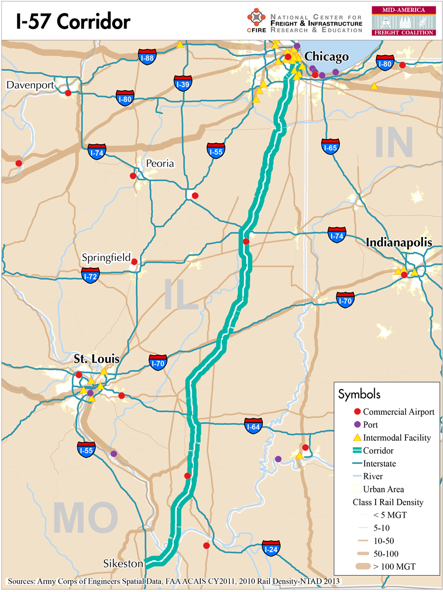
I-57 is a major north-south interstate route in the MAFC. I-57 begins at the junction of US 60 and I-55 in Sikeston Missouri and crosses the Mississippi River at Cairo, Illinois. I-57 then runs diagonally towards Chicago as it crosses the state. While I-57 crosses only two states in the MAFC, at I-55 in Missouri, the route can be used as a southern connector and short-cut around St Louis. From I-57, US 60 can be used to head west or reach US 67 towards Little Rock Arkansas for a southern route. In Chicago, I-57 terminates at I-94 which provides continued connections.
In Missouri, I-57 runs concurrent with US 60 east towards the Illinois state line. After crossing the bridge at Cairo, Illinois, I-57 is the longest interstate in Illinois. It runs concurrently with US 51 and then parallel with Illinois Route 37 as it travels north through the center part of the state. At Effingham, I-57 briefly runs concurrent with I-70 then parallel with US-45, then parallel with Illinois-50 to the junction of I-90/94.
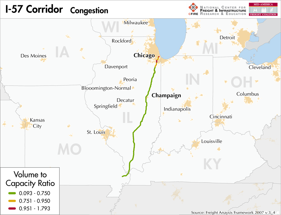
Interstate 57 in Missouri and Illinois is categorized as a Tier 2 corridor on the MAFC nationally significant corridor list. This status is based on moderate to heavy traffic volumes, the 2-state connection and its importance in connecting the southern states to Chicago as well as connecting I-24 from the south with I-64 for the east and west. Outside of the Chicago metro area, the section between the junction with I-24 and I-64 has the highest truck volumes demonstrating the significant connector role this facility has.
In Missouri, I-57 is listed as a designated truck route on the states vehicle route map , and all of I-57 in Illinois is listed on the IDOT Designated Truck Route list I-57 is not tolled in either Missouri or Illinois but in the Chicago area. I-57 is inescapably linked to a variety of interstates and freeway some of which are tolled. The numbers of interstate connections with I-57 are significant. From south to north, I-57 connects with 8 other interstates: I-55, I-24, I-64, I-70, I-72, I-74, I-80/294 and I-94.
In terms of multimodal access and redundancy, I-57 crosses the Mississippi River at Cairo and terminates at I-94 near the Great Lakes. With these connections there is a limited possibility of alternate moves for the corridor from the Mississippi River to the Great Lakes. Rail facilities run parallel the entire length of I-57 and provide a link to Chicago as well as a variety of other crossing points along the corridor.
Similarly, the urban and community connections provided by I-57 are numerous. Beginning in Missouri at Sikeston, then crossing into Illinois I-57 serves the communities of Marion, Mt. Vernon, Effingham, Mattoon, Champaign-Urbana, Bourbonnais and then Chicago. While I-57 provides a shortcut to avoid St Louis on a northerly trek to Chicago, the corridor also plays a tremendous role in connections to other interstates especially providing a link to traffic on I-24 to I-64.
Metropolitan Statistical Areas Economic Profile
| MSA | Population | GDP (2011, in millions) | Employment | Freight-related Employment | Metropolitan Planning Organizations |
| Chicago (IL) | 9,461,105 | $547,609 | 4,333,730 | 1,706,242 | Chicago Metropolitan Agency on Planning |
| Kankakee-Bradley (IL) | 113,449 | $3,231 | 50,670 | 21,713 | Kankakee Area Transportation Study |
| Champaign-Urbana (IL) | 231,891 | $9,238 | 109,306 | 38,361 | Champaign Urbana Area Transportation Study |
| Cape Girardeau-Jackson (MO-IL) | 96,275 | $3,521 | 45,864 | 18,466 | Southeast MPO |
National Connectors
Chicago, IL
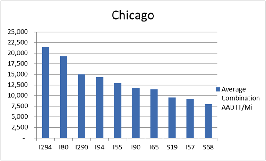
The interstates supporting freight originating in, destined for, and traveling through Chicago includes I-55, I-57, I-88, I-89, I-90, and I-94. In total, Chicago has 42 urban interstates, freeways, and expressways that support freight movements. Chicago’s geographic location as a crossroad of numerous interstates causes a dispersion of freight throughout a large network of national connectors and interstates that travel through the city. The average combination AADTT per mile on Chicago’s urban interstates, freeways, and expressways is over 10,000 trucks for seven roadways and nearly 20,000 combination trucks for two roadways.
Freight Projects Impacting Truck Traffic
Infrastructure in the burgeoning logistics centers developing in Will County, Illinois, south of Chicago continue to develop. The Illiana Corridor will connect I-55 to I-65 and also include a major interchange at I-57. This bi-state partnership seeks to relieve freight congestion on I-80 and I-94 by providing an alternative route outside of the Chicago metro area. This project will be developed with public-private financing.
Truck Traffic
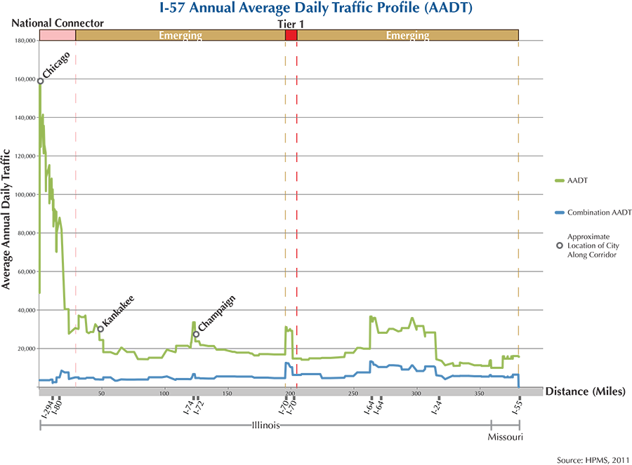
I-57 is a 380-mile corridor that crosses two states in the MAFC: Illinois and Missouri.
- VMT 2007: 9,226,580
- Truck VMT 2007: 2,816,633
- Percent Truck VMT: 30.5 percent
Operational Efficiency (ITS)
No message boards or cameras are located along the I-57 corridor.
Illinois collaborates with Indiana, Kentucky, and Ohio through ITS Midwest, whereas Missouri partners with Iowa, Kansas, Nebraska, and Oklahoma through ITS Heartland. Additionally, the Illinois DOT participates in the ENTERPRISE Pool Fund Study.
Greenhouse Gas Emissions
- Yearly tons of CO2 assuming 4 mpg: 2,300,000
- Yearly tons of CO2 assuming 7.5 mpg: 1,200,00
Methodology
- Data: Truck Counts (HPMS 2011)
- Assume 4 and 7.5 miles per gallon
- No control for level of service or elevation changes
- 22.3 lbs. of CO2 per gallon of diesel
Fuel and Truck Parking
| There are 29 fueling stops that also offer truck parking along I-57. Seven truck stops have less than 25 parking stops, 11 have between 25-84 spots, and 11 have 85+ spots of parking capacity. Compressed Natural Gas (CNG) and Liquified Natural Gas (LNG) stations are listed to the right. | I-57 | CNG | LNG |
| Public | 0 | 0 | |
| Private | 1 | 0 | |
| Planned | 0 | 0 | |
| Total | 1 | 0 |
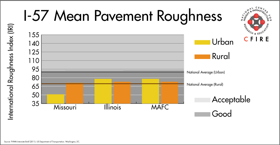
Infrastructure Condition
The International Roughness Index (IRI) measures the cumulative amount of vertical deviation (the bumpiness or roughness) for each segment of road, and is reported as a ratio in inches per mile. IRI values less than 95 are generally considered good, while values between 95 and 170 are generally considered acceptable. Since only corridor segments with reported IRI values from the 2011 HPMS dataset were considered in this analysis, some states may be missing from certain corridors.
The IRI is used as a measurement to determine infrastructure conditions within the Highway Performance Monitoring System (HPMS) such as pavement deterioration, pavement condition trends, cost allocation studies, and other analytical purposes. It is reported, at a minimum, for all road segments that fall under the Full Extent classification which includes the National Highway System (NHS), all principal arterials (interstates, freeways, and expressways), and rural minor arterials within the Sample Panel dataset. The data is collected by the states and submitted to the FHWA. The FHWA verifies the data, and houses it within the HPMS. For more historical information, see MnDOT’s Introduction to the International Roughness Index.
Freight Facilities
Intermodal Terminals
- CN Harvey (IL) Intermodal Terminal: TOFC-COFC (<400,000 lefts/yr.)
- Iowa Interstate RR System (IAIS) Blue Island, IL: COFC (<30,000 lifts/yr.)
- Norfolk Southern (NS) Calumet IL: TOFC-COFC (<50,000 lifts/yr.)
- Union Pacific (UP) Yard Center Dolton, IL: TOFC-COFC (<300,000 lifts/yr.)
Major Freight Yards
- Barr Yard: Chicago
- Yard Center: Dolton
Other Freight Yards
- Homewood
- Matteson
- Kankakee
- Champaign
- Effingham
- Matoon
- Salem
Airports
- Chicago O’Hare International (ORD)
Ports
- Port of Chicago
- Port of Indiana – Mount Vernon
- Southeast Missouri Regional Port
Automotive Distribution Centers
- Harvey, IL-CN Markham
Freight Rail
This is a multimodal corridor from Chicago to Salem, IL. The Canadian National (CN) operates over the Chicago and Champaign Subdivisions within the I-57 corridor. At Champaign, the CN Centralia Subdivision leaves the corridor but re-enters the corridor in southern Illinois. This alignment (including CN Bluford Subdivision, east of I-57) is Canadian National’s mainline to Memphis and to the ports of New Orleans and Mobile. CN purchased the line work from the Illinois Central in 1999. It is referred to as the Illinois Central Corridor (IC). According to CN (5), rail density along the IC corridor (2010) is between 30-50 million gross tons (MGT) per mile. The Illinois Basin is a major bituminous coal producing area and includes the coalfields of Illinois, Indiana and western Kentucky. Illinois Basin coal is increasingly exported via the Mississippi River. The Union Pacific (UP), BNSF and Norfolk Southern (NS) have light density segments that run along I-57 south from Salem to connections with higher density east-west lines.
Passenger Rail
Passenger rail service runs parallel to the I-57 corridor for a great portion of the corridor (260 rail miles). Three services are provided: the long distance, City of New Orleans, Illini, and Saluki (Chicago-Champaign-Carbondale) Route. The southernmost Amtrak station in the I-57 corridor is Effingham, IL.
Airports
Chicago O’Hare is the one air cargo airport to service the I-57 Corridor.
Although the I-57 Corridor is not directly connected to Chicago O’Hare (ORD), the corridor is adjacent to the primary hub airport. ORD is the 3rd ranked air cargo airport in the MAFC region and ranked 6th nationally in terms of 2012 landed cargo weight. UPS and FedEx air cargo facilities are both present at ORD.
| Chicago O’Hare International (ORD) | |
| Cargo Facilities | Mechanical Handling, Heated Storage, Air-Conditioned Storage, Refrigerated Storage, Deep Freeze Storage, Mortuary, Animal Quarantine, Fresh Meat Inspection, Health Officials, X-Ray Equipment, Decompression Chamber, Security for Valuables, Dangerous Goods, Radioactive Goods, Very Large/Heavy Cargo, Express/Courier Centre Cargo; Handling Agents:Evergreen/EAGLE, Servisair/GlobeGround |
| Cargo Terminals | 15 |
| Number of Runways (max. length) | 5 (12,998 feet) |
| Warehouses & DCs within 5/10 miles | 27 / 56 |
| Air Cargo Businesses within Urban Area | 3,339 |
| 2011 Landed Weight (lbs.) | 4,368,420,500 |
| 2010 Landed Weight (lbs.) | 4,895,940,100 |
| Change (Percentage) | -10.77% |
| Intermodal Connectors (5/10 miles) | 7 / 28 |
Ports
There are no navigable waterways that directly serve as a Marine Highway reliever route to I-57. However, the portion of M-55 consisting of the Illinois River Waterway and the Mississippi River between Chicago and Cairo, IL could potentially serve as a Marine Highway freight reliever route to I-57. The largest river ports along the Illinois route include Chicago, Joliet, Peoria, and Cairo in Illinois and St. Louis, MO.


Freight Generators, Warehouses, and Distribution Centers
There are a total of 10,455 freight generators employing 141,437 people within three miles of the corridor, and a total of 29,727 freight generators employing 387,515 people within 10 miles of the corridor. If the extent of analysis focuses on the metropolitan statistical areas (MSAs) intersected by the I-57 corridor, there are a total of 118,310 freight generators employing 1,784,782 people. Within the MSAs, there are a total of 403 warehousing & distribution centers employing 7,394 people. Freight generators were determined by using the NAICS codes prescribed for freight-related sectors in NCFRP Report 19, and include agriculture, mining, manufacturing, wholesale trade, retail trade, transportation & warehousing, and eating & drinking places.
Major Manufacturers |
Major Distribution Centers |
|
|
References
- Interstate 57. Wikipedia.
- Missouri Vehicle Route Map: 2012-2013. Missouri Department of Transportation.
- Illinois Designated Truck Route List. Illinois Department of Transportation.
- FHWA Interstate Brief (2011). US Department of Transportation.
- CN 2011 Investor Fact Book.