DRAFT
Hannibal, Missouri to Champaign, Illinois
Snapshot: Length: 184 miles | Length in MAFC: 184 miles | Intersecting Interstates: I-55, I-57, I-74
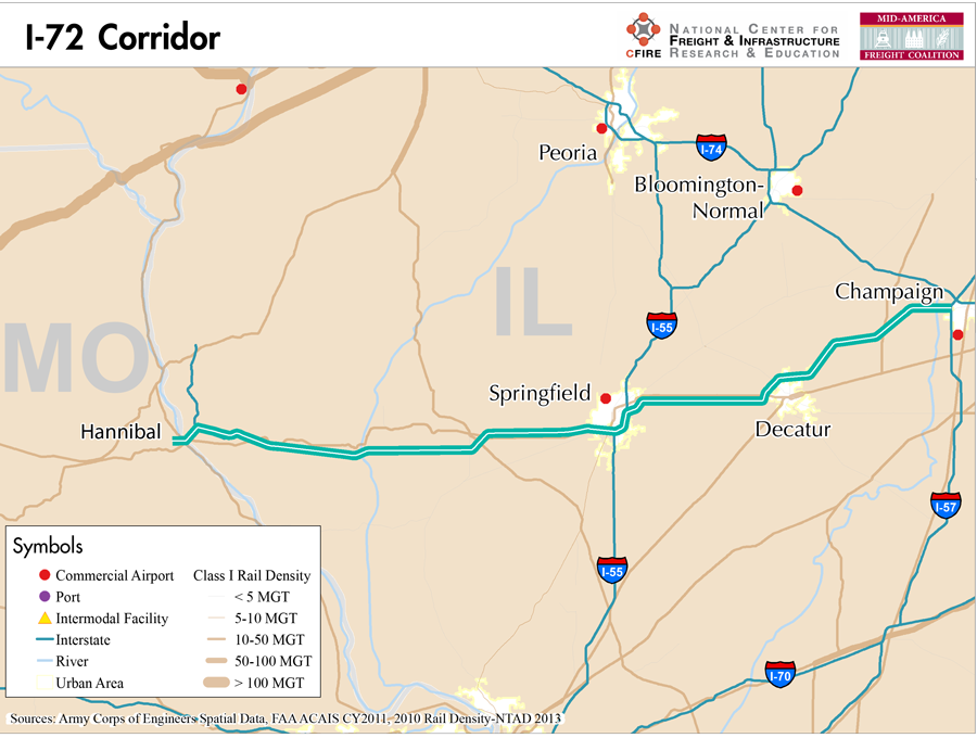
I-72 currently runs from Hannibal, MO, only two miles from the Illinois state border to Champaign, IL. I-72 serves as a significant portion of the Illinois side of the Chicago-Kansas City Expressway concept, which follows US-36 across northern Missouri. The Chicago-Kansas City Expressway was originally intended to connect Chicago, to the north–south NAFTA corridors and provide an alternate route for freight traveling on I-70 and I-80.
The MAFC Regional Freight Study considers I-72 an important emerging freight corridor because of the connections that it provides. It has connections in central Illinois with both I-55 and I-57 and provides an east-west alternative to the heavily trafficked I-70 and I-80 corridors. The Chicago-Kansas City Expressway is up to Interstate standards along its entire route, which also utilizes I-35 and I-55 to connect these two major cities.
I-72 is not tolled at any point during its current extent. The Illinois Department of Transportation lists it as a Designated Truck Route.
Norfolk Southern provides rail service along almost exactly the same corridor as I-72 from Champaign, IL west and even to Kansas City along the US-36 route. There is no east-west waterway that serves this specific route.
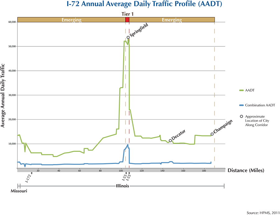
I-72 serves the cities of Springfield, Decatur and Champaign. Its sole business route passes through Jacksonville, IL, west of Springfield.
Corridor_I72.pdf
Metropolitan Statistical Areas Economic Profile
| MSA | Population | GDP (2011, in millions) | Employment | Freight-related Employment | Metropolitan Planning Organizations |
| Springfield (IL) | 210,170 | $9,917 | 138,352 | 30,314 | Springfield Area Transportation Study |
| Decatur (IL) | 110,768 | $5,584 | 58,085 | 27,738 | Macon County Regional Planning Commission |
| Champaign-Urbana (IL) | 231,891 | $9,238 | 109,306 | 38,361 | Champaign Urbana Area Transportation Study |
National Connectors
There are no national connectors along the I-72 corridor in the MAFC region.
Freight Projects Impacting Truck Traffic
Several projects along I-72 include routine maintenance in Illinois, while in Missouri most of US 36 has been upgraded to interstate standards with the intention of eventually extending I-72 across the state to Kansas City from its current terminus just west of Hannibal, Missouri.
Truck Traffic
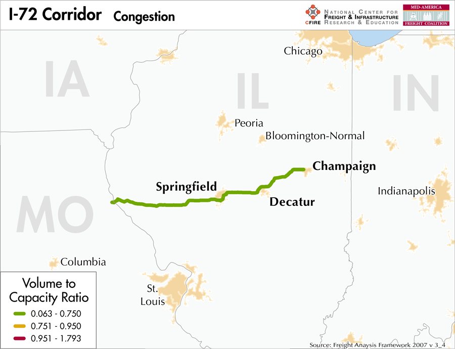
I-72 is a 184-mile corridor that passes through two MAFC states: Missouri and Illinois.
- VMT 2007: 5,971,435
- Truck VMT 2007: 1,316,030
- Percent Truck VMT: 22.04 percent

Operational Efficiency (ITS)
There are no cameras or message boards along the I-72 Corridor.
Illinois collaborates with Indiana, Ohio, and Kentucky through ITS Midwest. Additionally, the Illinois DOT participates in the ENTERPRISE Pooled Fund Study.
Greenhouse Gas Emissions
- Yearly tons of CO2 assuming 4 mpg: 340,000
- Yearly tons of CO2 assuming 7.5 mpg: 180,000
Methodology
- Data: Truck Counts (HPMS 2011)
- Assume 4 and 7.5 miles per gallon
- No control for level of service or elevation changes
- 22.3 lbs. of CO2 per gallon of diesel
Fuel and Truck Parking
| There are 3 fueling stops that also offer truck parking along I-72. Zero truck stops have less than 25 parking stops, 3 have between 25-84 spots, and 0 have 85+ spots of parking capacity. Compressed Natural Gas (CNG) and Liquified Natural Gas (LNG) stations are listed to the right. | I-72 | CNG | LNG |
| Public | 0 | 0 | |
| Private | 0 | 0 | |
| Planned | 0 | 0 | |
| Total | 0 | 0 |
Infrastructure Condition
The International Roughness Index (IRI) measures the cumulative amount of vertical deviation (the bumpiness or roughness) for each segment of road, and is reported as a ratio in inches per mile. IRI values less than 95 are generally considered good, while values between 95 and 170 are generally considered acceptable. Since only corridor segments with reported IRI values from the 2011 HPMS dataset were considered in this analysis, some states may be missing from certain corridors.
The IRI is used as a measurement to determine infrastructure conditions within the Highway Performance Monitoring System (HPMS) such as pavement deterioration, pavement condition trends, cost allocation studies, and other analytical purposes. It is reported, at a minimum, for all road segments that fall under the Full Extent classification which includes the National Highway System (NHS), all principal arterials (interstates, freeways, and expressways), and rural minor arterials within the Sample Panel dataset. The data is collected by the states and submitted to the FHWA. The FHWA verifies the data, and houses it within the HPMS. For more historical information, see MnDOT’s Introduction to the International Roughness Index.

Freight Facilities
Intermodal Terminals
- Archer Daniels Midland (ADM) Company Rail and Intermodal Logistics Facility (lift capacity 60,000/yr.)
Major Rail Yards
- Decatur
Freight Rail
A majority of the I-72 corridor has a parallel freight line. Rail density runs from 10-50 million gross tons-MGT according to the 2013 National Transportation Atlas (featuring 2010 data). The Norfolk Southern railroad runs from Hannibal to Decatur approximately 200 rail miles with a short segment outside the corridor. Other rail lines that cross the corridor are shared-use freight and passenger. Springfield is the terminus of the Kansas City Southern line.
Emerging Intermodal
One of ADM’s major domestic investments has been in a new rail and intermodal yard at a large manufacturing complex in Decatur, IL. ADM recently consolidated multiple rail yards for the Norfolk Southern, Canadian National Railway and CSX into a central yard between its two primary plants and took over switching operations from the railroads. Developing a private intermodal terminal is a new trend among large producers in order to ensure a reliable supply chain to export markets for specialized grain. ADM contracts with RailServe to load and move cars to the mainline. Canadian National, Norfolk Southern, and CSX mainlines access the facility. The facility relies on rail for inbound as well as outbound moves. By eliminating outbound trucks, containers can be loaded heavier for export. ADM also ships out liquids in flexitanks. ADM’s subsidiary, American River Transportation, has a fleet of 1,700 barges, 58 tug boats, 29 line boats, 26,100 railcars, 700 trucks, 1,500 trailers and 8 handy, handymax, spuramax and panamax vessels as well as 3 dry bulk post-panamax carriers (1).
Passenger Rail
There is no passenger rail that runs along I-72. Two services: the Lincoln Service (Chicago-St. Louis) and the Texas Eagle (Chicago-St. Louis-Dallas-San Antonio-LA) cross the corridor in Springfield. This segment is part of the high-speed corridor from Chicago to St. Louis. Currently a draft environmental impact statement (DEIS) has offered some alternatives for improved efficiencies between freight and passenger uses. The alternative 2A proposes relocating the existing UP freight and passenger rail corridor to a new location parallel to the Norfolk Southern tracks on 10th Street.
Outside of the I-72 corridor, the City of New Orleans, the Saluki and Illini services have a station stop in Champaign. Freight traffic through Springfield and Champaign is between 10-50 MGT.
Airports
There are no air cargo airports along the I-72 corridor in the MAFC region.
Ports
There no Marine Highway Corridors which run parallel to the I-72 corridor. However, I-72 does intersect the M-55 Marine Highway which provides access to other marine highways such as M-90 and the Great Lakes, M-70 and the Missouri and Ohio Rivers, and ultimately M-19 and the Gulf of Mexico.

Freight Generators, Warehouses, and Distribution Centers
There are a total of 2,555 freight generators employing 43,983 people within three miles of the corridor, and a total of 6,321 freight generators employing 97,883 people within 10 miles of the corridor. If the extent of analysis focuses on the metropolitan statistical areas (MSAs) intersected by the I72 corridor, there are a total of 6,493 freight generators employing 96,413 people. Within the MSAs, there are a total of 89 warehousing & distribution centers employing 678 people. Freight generators were determined by using the NAICS codes prescribed for freight-related sectors in NCFRP Report 19, and include agriculture, mining, manufacturing, wholesale trade, retail trade, transportation & warehousing, and eating & drinking places.
References
- Dupin, C. All Points on the Compass. American Shipper, Oct. 2012, pp. 38-40.
- FHWA Interstate Brief (2011). US Department of Transportation.