DRAFT
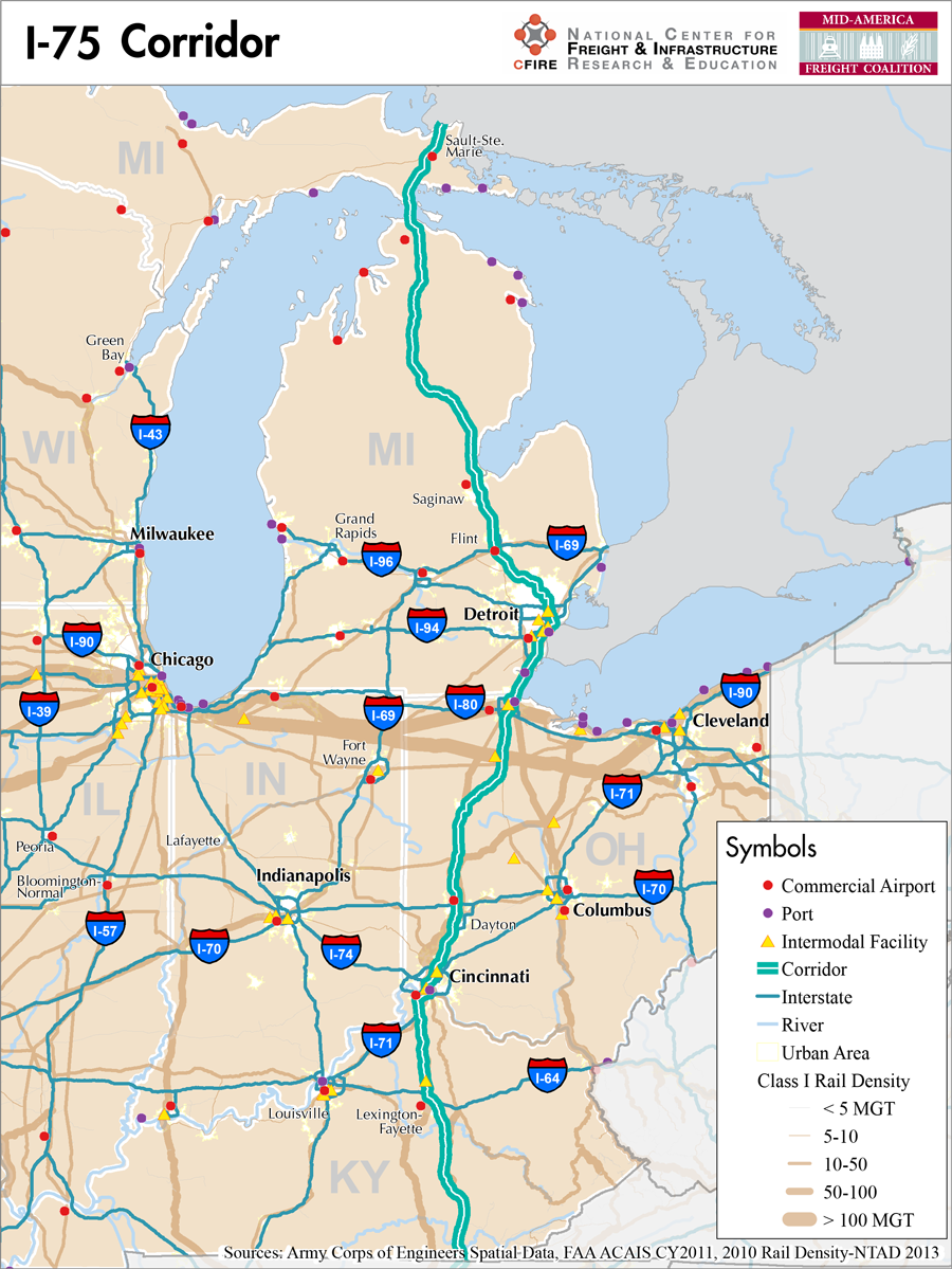
Southern Kentucky to Sault Ste. Marie, Michigan
Snapshot: Length: 1,787 miles | Length in MAFC: 801 miles | Intersecting Interstates:I-4, I-10, I-16, I-20, I-24, I-40, I-64, I-69, I-70, I-80, I-85, I-90, I-94
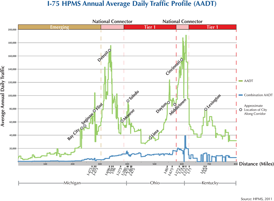
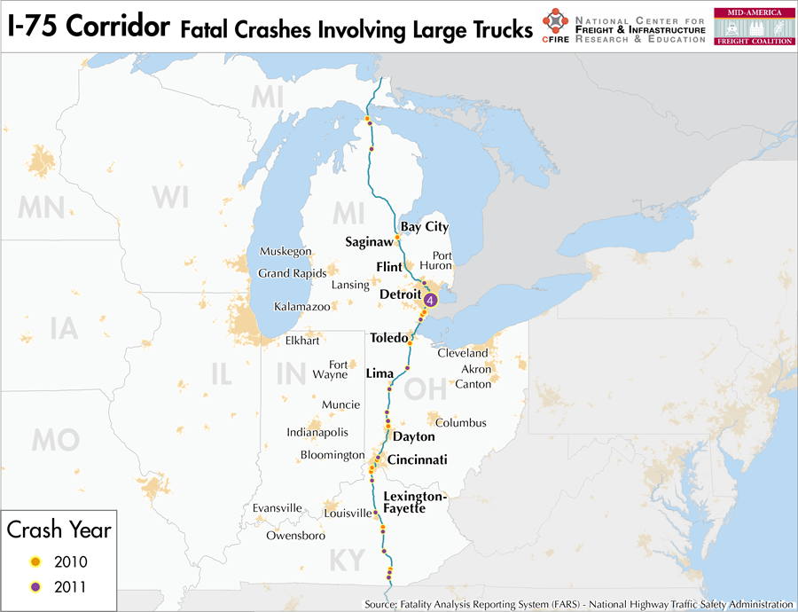
I-75 travels from Miami, FL to the International Bridge in Sault Ste. Marie at the Canadian border. It passes through the MAFC states of Kentucky, Ohio, and Michigan, as well as several major cities within these states. Important urban areas include Lexington, KY (the 106th largest MSA in the US), Cincinnati, OH (28th largest), Toledo, OH (89th), and Detroit, MI (14th). No other Interstate Highway serves the upper peninsula of Michigan.
The I-75 corridor qualifies as a Tier I corridor in the MAFC regional freight study from the point it enters the MAFC region at the Kentucky-Tennessee border until it leaves the metro area of Detroit, after which it is briefly considered an emerging corridor until the city of Flint, MI. I-75 is an important north-south highway connecting industrial centers in the south and within the MAFC region, including the important freight generating and receiving cities of Cincinnati and Detroit. Additionally, I-75 is a northern US border crossing at Sault Ste. Marie. Within the portion of I-75 categorized as a Tier 1 corridor for the MAFC region, I-75 is six to eight lanes for almost its entire duration with ten lanes for a segment through Detroit. Ohio is preparing plans for significant improvements along I-75 from the Kentucky border through the Cincinnati suburbs that should reduce congestion in that area.
In cooperation with several shortline railroads, CSX provides rail service along a route roughly equivalent to I-75 from Cincinnati to Detroit. A Norfolk Southern line heads south from Cincinnati, also following a route quite similar to I-75’s route to the Tennessee border. There are no similar maritime routes along the I-75 corridor. However; M-75 has been designated as a Marine Highway crossing between Detroit and Windsor, Canada. At the time of MARAD marine highway designation, the crossing handled trade in excess of $122 billion.
Tolls are not applied at any location along the I-75 corridor, although it does cross the Ohio Turnpike/I-80/I-90 just south of Toledo, which is the largest toll road running through Ohio.
Beginning at the Kentucky border, I-75 connects Lexington-Fayette in central Kentucky with Cincinnati, Dayton, and Toledo in western Ohio before crossing into Michigan where it connects Detroit with Pontiac and Flint before crossing the border into Canada at Sault Ste. Marie.
Metropolitan Statistical Areas Economic Profile
| MSA | Population | GDP (2011, in millions) | Employment | Freight-related Employment | Metropolitan Planning Organizations |
| Bay City (MI) | 107,771 | $2,895 | 42,297 | 18,875 | Bay County Area Transportation Study |
| Saginaw (MI) | 200,169 | $6,773 | 106,858 | 44,171 | Saginaw Metropolitan Area Transportation Study |
| Flint (MI) | 425,790 | $11,325 | 153,124 | 59,042 | Genesee County Metropolitan Planning Commission |
| Detroit (MI) | 4,296,250 | $199,378 | 1,862,383 | 782,451 | Southeast Michigan Council of Governments |
| Monroe (MI) | 152,021 | $3,738 | 44,408 | 19,238 | Southeast Michigan Council of Governments |
| Toledo (OH) | 610,001 | $28,037 | 341,253 | 137,872 | Toledo Metropolitan Area Council of Governments |
| Lima (OH) | 106,331 | $4,865 | 60,756 | 25,712 | Lima-Allen County Regional Planning Commission |
| Dayton (OH) | 799,232 | $33,915 | 414,916 | 159,460 | Miami Valley Regional Planning Commission |
| Cincinnati (OH-IN-KY) | 2,114,580 | $102,469 | 1,045,722 | 441,210 | Ohio-Kentucky-Indiana Regional Council of Governments |
| Lexington-Fayette (KY) | 472,099 | $22,782 | 250,846 | 103,215 | Lexington Area MPO |
National Connectors
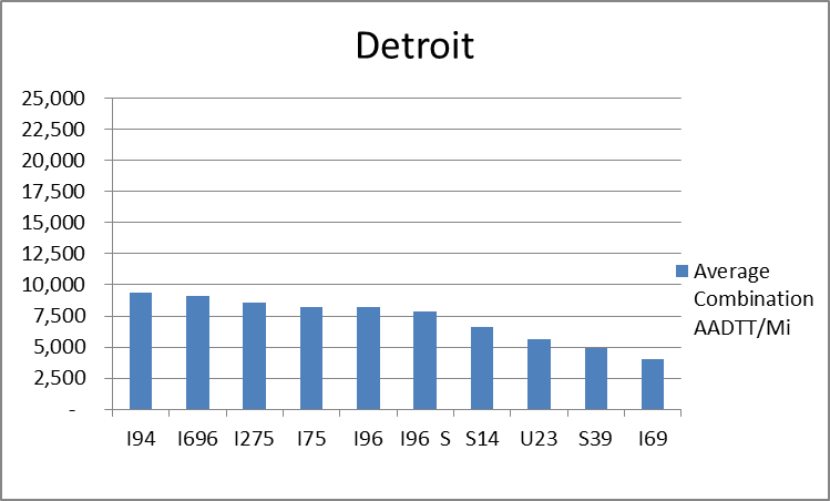
Detroit, MI
The interstates supporting freight originating in, destined for, and traveling through the Detroit include I-94, I-75, and I-96. In total, Detroit has 23 urban interstates, freeways, and expressways that support freight movements. Detroit has a widely dispersed distribution of freight throughout its 23 urban connectors based on average combination AADTT per mile. The top four roadways by average combination AADTT per mile are I-94, I-696, I-275, and I-75.
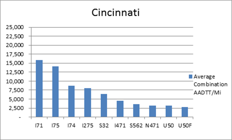
Cincinnati, OH
The interstates supporting freight originating in, destined for, and traveling through Cincinnati include I-71, I-75, and I-74. In total, Cincinnati has 22 urban interstates, freeways, and expressways that support freight movements. I-71, I-74, and I-75 transport 70 percent of combination truck miles within Cincinnati and are the top three roadways based on average combination AADTT per mile.
Freight Projects Impacting Truck Traffic
- Work being done along the I-75 corridor is mostly standard rehabilitation and reconstruction work and includes long term projects to widen some portions of the route in Kentucky. The most significant changes to the corridor are the ones being examined by Ohio in the Cincinnati area.
- Ohio DOT is studying a number of portions of I-75 in the Cincinnati area beginning at the Kentucky border with the Brent Spence Bridge Project, the Mill Creek Expressway Project, and the Thru the Valley Project.
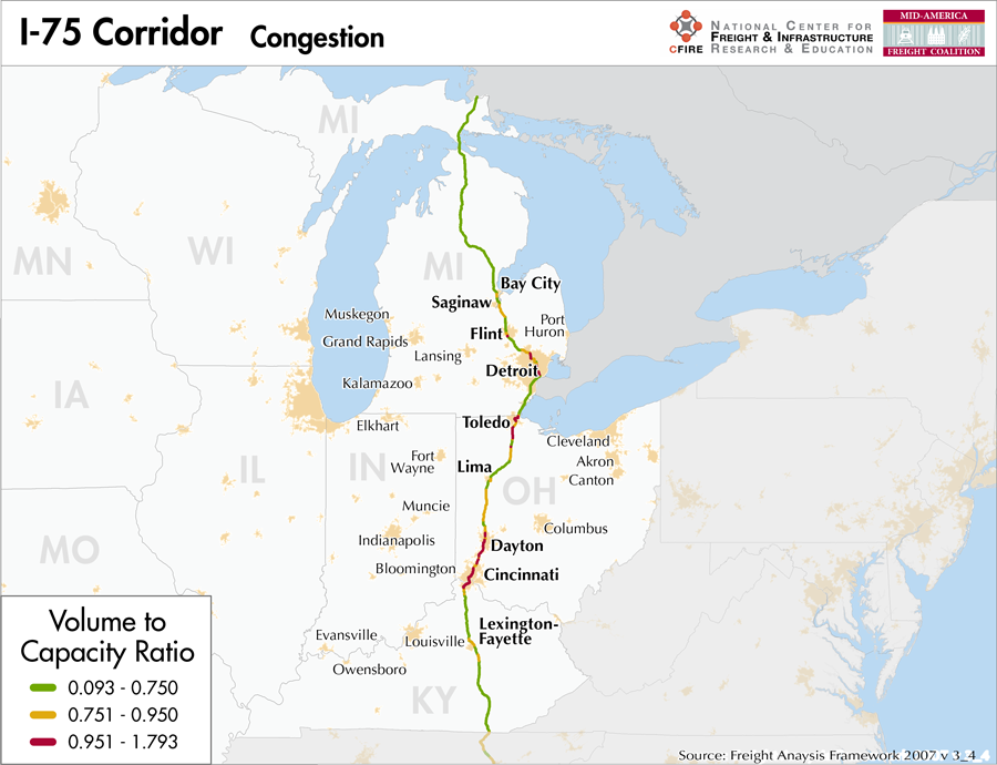
Truck Traffic
I-75 is an 801-mile corridor that crosses three states in the MAFC: Kentucky, Ohio, and Michigan.
- VMT 2007: 37,707,776
- Truck VMT 2007: 7,201,177
- Percent Truck VMT: 19.1 percent
Operational Efficiency (ITS)
Message boards (63) and cameras (125) are found throughout the I-75 corridor, with a majority found in urban areas (44 message boards and 106 cameras). The largest clusters of message boards are found in Detroit (20) and Cincinnati (13). Displaying a very similar pattern of distribution, cameras are also concentrated in these metropolitan areas, with 30 and 57 found in Detroit and Cincinnati, respectively.
Michigan has an individual membership in ITS America, whereas Kentucky and Ohio collaborate with Illinois and Indiana through ITS Midwest. Additionally, Michigan DOT participates in the ENTERPRISE Pool Fund Study.
Greenhouse Gas Emissions
- Yearly tons of CO2 assuming 4 mpg: 5,200,000
- Yearly tons of CO2 assuming 7.5 mpg: 2,800,000
Methodology
- Data: Truck Counts (HPMS 2011)
- Assume 4 and 7.5 miles per gallon
- No control for level of service or elevation changes
- 22.3 lbs. of CO2 per gallon of diesel
Fuel and Truck Parking
| There are 57 fueling stations along I-75 that also offer truck parking. 21 fueling stops have less than 25 truck parking spaces, 16 have between 25 and 84 truck parking spaces, and 20 have 85+ truck parking spaces. Compressed Natural Gas (CNG) and Liquefied Natural Gas (LNG) stations are listed to the right. | I-75 | CNG | LNG |
| Public | 1 | 0 | |
| Private | 0 | 0 | |
| Planned | 0 | 0 | |
| Total | 1 | 0 |
Infrastructure Condition
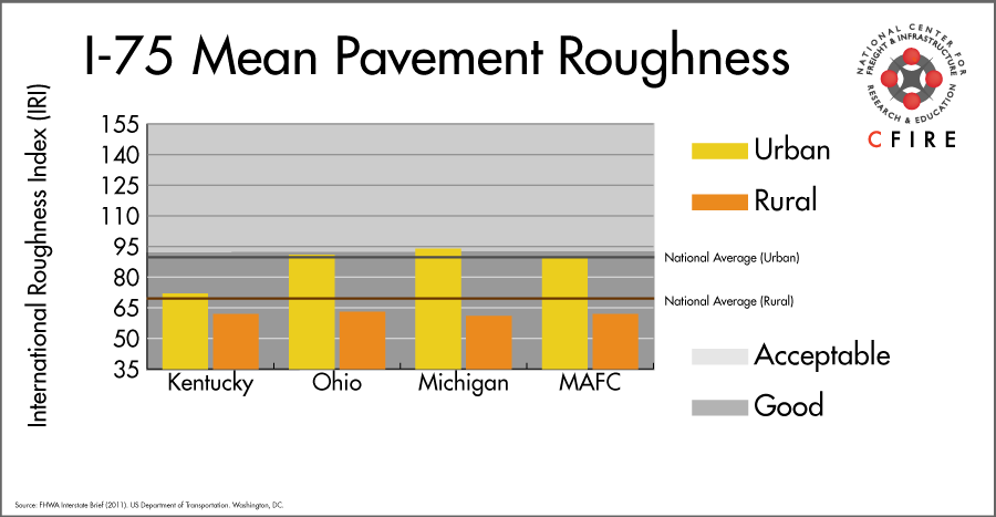
The International Roughness Index (IRI) measures the cumulative amount of vertical deviation (the bumpiness or roughness) for each segment of road, and is reported as a ratio in inches per mile. IRI values less than 95 are generally considered good, while values between 95 and 170 are generally considered acceptable. Since only corridor segments with reported IRI values from the 2011 HPMS dataset were considered in this analysis, some states may be missing from certain corridors.
The IRI is used as a measurement to determine infrastructure conditions within the Highway Performance Monitoring System (HPMS) such as pavement deterioration, pavement condition trends, cost allocation studies, and other analytical purposes. It is reported, at a minimum, for all road segments that fall under the Full Extent classification which includes the National Highway System (NHS), all principal arterials (interstates, freeways, and expressways), and rural minor arterials within the Sample Panel dataset. The data is collected by the states and submitted to the FHWA. The FHWA verifies the data, and houses it within the HPMS. For more historical information, see MnDOT’s Introduction to the International Roughness Index.
Freight Facilities
Intermodal Terminals
- Triple Crown RoadRailer (Detroit)
- Canadian National (CN) Moterm: TOFC-COFC (Detroit)
- CSX Dix Avenue: TOFC-COFC (Detroit)
- NS Airline Junction – Toledo: TOFC-COFC (Capacity 60,000 lifts/yr.)
- CSX Northwest Baltimore ICTF (>500,000 lifts/yr.)
- CSX Queensgate Cincinnati: TOFC-COFC (<50,000 lifts/yr.)
- Norfolk Southern (NS) Cincinnati-Gest: TOFC-COFC (<100,000 lifts/yr.)
- Norfolk Southern (NS) Cincinnati-Sharonville: COFC (< 40,000 lifts/yr.)
- Norfolk Southern (NS) Georgetown, KY: TOFC-COFC (<60,000 lifts/yr.)
Major Rail Yards
- Detroit: Livernois, Rougemere, East, Melvindale, Flat Rock
- Toledo: Stanley, Rossford, Airline Junction, Delta, Oakdale
- Cincinnati: Queensgate, Gest Street, Sharon, ON
- Corbin, KY: Corbin
Airports
- Cincinnati/Northern Kentucky International (CVG)
- Toledo Express (TOL)
- Detroit Metropolitan Wayne County (DTW)
- Willow Run (YIP)
- Bishop International (FNT)
- James M Cox Dayton International (DAY)
Ports
- Port of Cincinnati
- Port of Toledo – Lucas County
- Port of Detroit
Automotive Distribution Centers
- Georgetown, KY (NS)
- Cincinnati, OH-(CSX-Total Transportation Distribution Service)
- Melvindale, MI-(NS)
- Detroit-Huber Yard, Dodge City Auto Terminal, Jefferson Avenue Auto Terminal, (NS)
- Flat Rock, MI (CN)
- Brownstown, MI (CN)
- Dearborn, MI (CN)
Freight Rail
The majority of this corridor offers parallel freight rail service. Most of the coverage is by Class I railroads except in Michigan. The heaviest rail density per 2010 data (over 100 million gross tons-MGT) occurs between Cincinnati and Sidney, OH (1).
Emerging Intermodal
In 2011, CSX opened the Northwest Ohio Intermodal Container Terminal Facility (ICTF), approximately 40 miles south of Toledo and five miles west of I-75 in New Baltimore, OH. The facility can handle both TOFC-COFC and has a capacity of two million lifts per year. The facility is at the heart of CSX’s National Gateway Project, bringing both east and west coast traffic to NW Ohio ICTF, which serves as a hub. Trains are reassembled for regional delivery to the other intermodal terminals in the Midwest. Through trackage rights with CSX, trains destined to Chicago for interchange can now bypass Chicago and go directly to New Baltimore.
Passenger Rail
There is no passenger service that parallels this entire corridor. There are a few segments that fall within the I-75 corridor. Those segments and services include: Pontiac to Detroit (Blue Water), Detroit to Dearborn (Wolverine), and a 27-mile segment near Cincinnati (Cardinal/Hoosier State).
Routes that cross the corridor include: near Flint, the Blue Water service, and at Toledo (Lake Shore Limited, Capitol Limited). In all, the following stations can be found in the I-75 corridor: Detroit, Birmingham, Pontiac, and Royal Oak in Michigan, Cincinnati and Toledo in Ohio.
Airports
There are six air cargo airports that service the I-75 corridor.
- CVG in northern Kentucky (Cincinnati) is the busiest airport along the I-75 corridor in terms of landed weight in 2012, ranking 4th within the MAFC region and 9th nationally. It is considered a primary hub airport, and is serviced by both UPS and FedEx Express.
- TOL in Toledo ranked 24th within the MAFC region and 107th nationally. TOL is considered a primary hub airport, and was the former air cargo hub for BAX Global. Neither UPS nor FedEx have an air cargo facility at TOL.
- DTW and YIP in Detroit, FNT in Flint, and DAY in Dayton are also air cargo airports on the I-75 corridor ranking 8th, 17th, 25th, and 26th respectively within the MAFC region and 35th, 83rd, 117th, and 118th nationally. DTW, FNT, and DAY are considered primary hub airports. UPS has air cargo facilities at DTW and DAY, while FedEx has air cargo facilities at DTW, FNT, and DAY.
| Toledo Express (TOL) | Detroit Metropolitan Wayne County (DTW) | Willow Run (YIP) | Bishop International (FNT) | James M Cox Dayton International (DAY) | |
| Cargo Facilities | Bonded Warehouse, Transit Zone, Free Port/Foreign Trade Zone, Mechanical Handling, Heated Storage, Air-Conditioned Storage, Refrigerated Storage, X-Ray Equipment, Security for Valuables, Dangerous Goods, Radioactive Goods, Very Large/Heavy Cargo | Mortuary | Free Port/Foreign Trade Zone | Warehouse 18 600m² (200 208sq ft), 78x 747 Freighter Docks, Bonded Warehouse, Free Port/Foreign Trade Zone, Aircraft Maintenance, Mechanical Handling, Heated Storage, Air-Conditioned Storage, Deep Freeze Storage, Livestock Handling, Health Officials, X-Ray Equipment, Security for Valuables, Fumigation Equipment, Dangerous Goods, Radioactive Goods, Very Large/Heavy Cargo, Express/Courier Centre | |
| Cargo Terminals | 1 | 3 | 1 | ||
| Number of Runways (max. length) | 2 (10,600 feet) | 5 (12,004 feet) | 5 (7,526 feet) | 2 (7,847 feet) | 3 (10,902 feet) |
| Warehouses & DCs within 5/10 miles | 1 / 5 | 10 / 30 | 3 / 19 | 7 / 18 | 8 / 21 |
| Air Cargo Businesses within Urban Area | 254 | 2,324 | 2,324 | 122 | 437 |
| 2011 Landed Weight (lbs.) | 650,714,500 | 602,804,150 | 246,739,675 | 73,214,150 | 43,372,800 |
| 2010 Landed Weight (lbs.) | 894,480,320 | 552,232,440 | 188,203,708 | 78,571,800 | 43,166,000 |
| Change (Percentage) | -27.25% | 9.16% | 31.10% | -6.82% | 0.48% |
| Intermodal Connectors (5/10 miles) | 5 / 6 | 6 / 11 | 4 / 15 | 0 / 0 | 4 / 7 |
Ports and Marine Highways
Though M-75 has been designated as a Marine Highway crossing between Detroit and Windsor, Canada, its short overall length make it an unlikely reliever without another marine highway. M-90 could potentially serve as a Marine Highway reliever route to I-75 for freight movements between Sault St. Marie, MI on the southeastern shore of Lake Superior to Toledo, OH. M-90 includes the four upper Great Lakes and reaches from Duluth, MN to the Hudson River in eastern New York State. I-75 closely parallels the southern shore of Lake Huron and the eastern shore of the St. Clair/Detroit River. Major commercial ports along this segment of I-75 include Mackinaw, MI; Saginaw, MI; St. Clair, MI; Detroit, MI, and Toledo, OH. The Ohio River (M-70) and Tennessee River (M-65) provide a potential—albeit indirect—river alternative to the portion of I-75 between the river port cities of Cincinnati, OH and Chattanooga, TN.

Freight Generators, Warehouses, and Distribution Centers
There are a total of 46,754 freight generators employing 873,041 people within three miles of the I-75 corridor, and a total of 92,119 freight generators employing 1,498,542 people within 10 miles of the corridor. If the extent of analysis focuses on the metropolitan statistical areas (MSAs) intersected by the I-75 corridor, there are a total of 111,377 freight generators employing 1,791,246 people. Within the MSAs, there are a total of 574 warehousing and distribution centers employing 7,838 people. Freight generators were determined by using the NAICS codes prescribed for freight-related sectors in NCFRP Report 19, and include agriculture, mining, manufacturing, wholesale trade, retail trade, transportation and warehousing, and eating and drinking places.
Major Manufacturers |
Major Distribution Centers |
|
|
References
- National Transportation Atlas Database (2013). Bureau of Transportation Statistics. US Department of Transportation. Washington, DC.
- FHWA Interstate Brief (2011). US Department of Transportation.