DRAFT
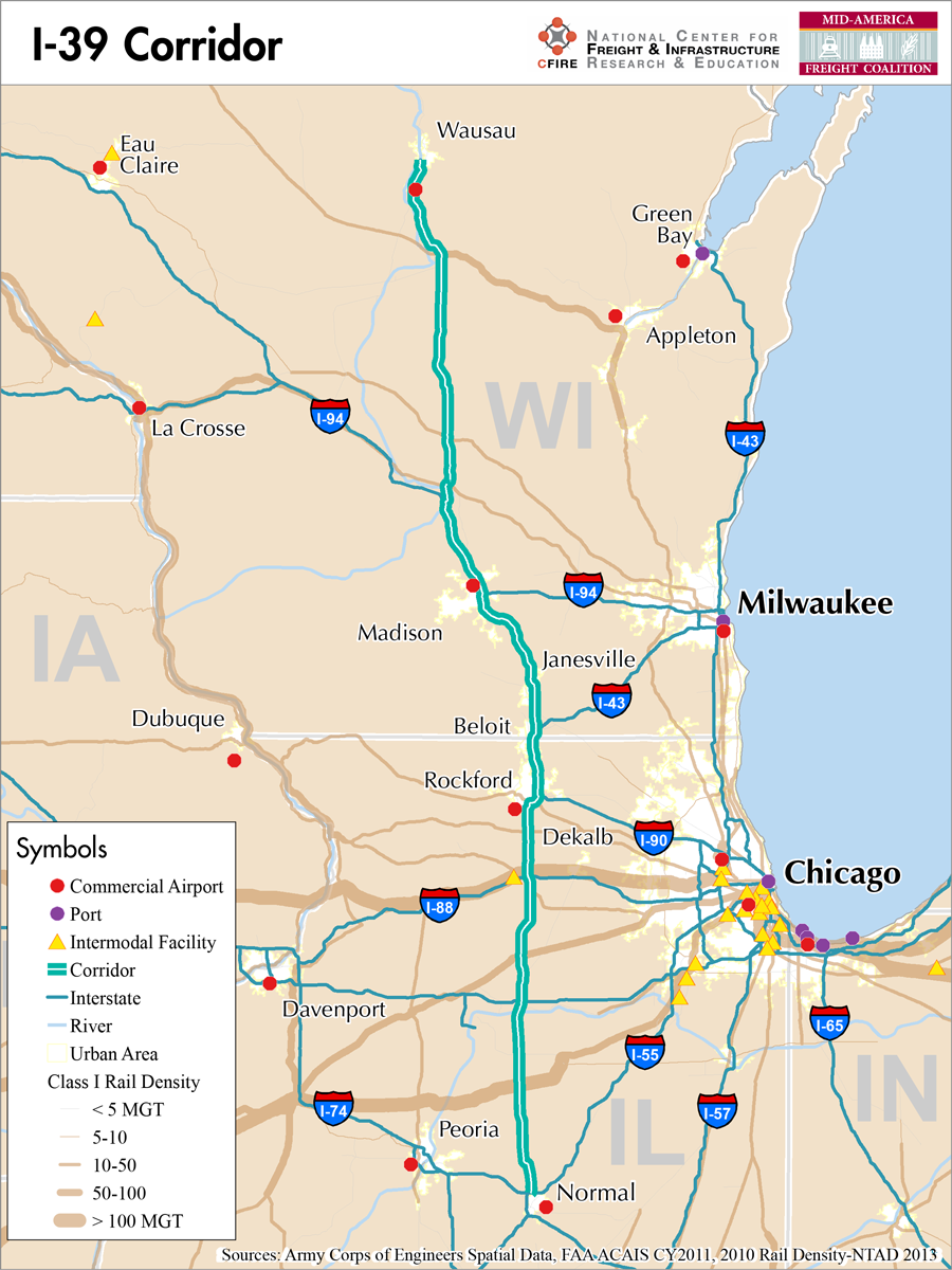
Normal, Illinois to Wausau (Rib Mountain), Wisconsin
Snapshot: Length: 306 miles | Length in MAFC: 284 miles | Intersecting Interstates: I-43, I-55, I-80, I-88, I-90, I-94
I-39 is north-south route connecting Wisconsin and Illinois in the MAFC region. I-39 is considered a Tier 1 and emerging corridor in the MAFC region due to its connections to I-55 in Illinois, and I-90 and I-94 in Wisconsin. I-39 does not extend to states outside of the MAFC region. In Illinois, I-39 is concurrently signed as US-51. From Rockford, Illinois to Portage, Wisconsin, it is also signed as I-90 in Wisconsin. And at Madison, WI I-94 also runs concurrently with I-39. At Portage, both I-94 and I-90 separate. Continuing north, the route continues as US-51/I-39 to Rib Mountain, WI in the Wausau area. At Wausau, US-51 continues into northern Wisconsin.
The need for I-39 was identified in 1945 with the original planning for the 40,000 miles of interstate highways. For a period, US-51 was considered one the most heavily traveled two-lane routes in the country (1). And while freight loads are not overwhelming on the majority of the route, it provides an important connection to agriculture, forestry, and industry in northern Wisconsin. In Illinois, the route was conceived of a part of a supplementary freeway system that would provide any Illinois resident access to an interstate highway within 30 minutes.
As an emerging corridor with moderate truck traffic that spans two states, the intestate connections of I-39 provide critical connections and redundancy for freight movement. In Illinois, I-39 connects to I-74, I-55, I-80 and I-90. In Wisconsin, I-39 runs concurrently with I-90 and I-94 and with US-51. US-51 continues and terminates at the northern border of Wisconsin (2). I-39 is listed as a designated truck route in Wisconsin. In Illinois, I-39 is also listed as a truck route from its intersection with I-55 to the Wisconsin border.
I-39, as a concurrent facility with I-90, is tolled as part of the Jane Addams Toll way. No other portions of the facility are currently tolled. I-39 begins at I-55 in Bloomington-Normal, and passes through the areas of Rochelle and Rockford, IL. After it crosses the Illinois border, I-39 passes through Beloit, Janesville, Madison, Portage, Stevens Point and Wausau, WI.
Metropolitan Statistical Areas Economic Profile
| MSA | Population | GDP (2011, in millions) | Employment | Freight-related Employment | Metropolitan Planning Organizations |
| Wausau (WI) | 134,063 | $5,831 | 73,483 | 38,284 | Marathon County Metropolitan Planning Commission |
| Madison (WI) | 605,435 | $36,526 | 418,168 | 129,459 | Dane County Regional Planning Commission |
| Janesville (WI) | 160,331 | $4,983 | 75,548 | 30,455 | Janesville Urbanized Area MPO |
| Rockford (IL) | 349,431 | $12,959 | 171,486 | 76,957 | Rockford Area Transportation Study |
| Peoria (IL) | 379,186 | $20,190 | 182,610 | 65,936 | Peoria/Pekin Urbanized Area Transportation Study |
| Bloomington-Normal (IL) | 169,572 | $9,535 | 112,151 | 26,872 | McLean County Regional Planning Commission |
Truck Traffic
I-39 is a 284-mile corridor that crosses two states in the MAFC: Wisconsin and Illinois.
- VMT 2007: 8,826,840
- Truck VMT 2007: 3,126,301
- Percent Truck VMT: 35.4 percent
Operational Efficiency (ITS)
Cameras are almost exclusively found along the portion of the I-39 corridor between the juncture with I-90 in Central Wisconsin and the Wisconsin-Illinois border. The greatest concentration of cameras is found around Madison (8 within 5 miles of the city limits). However, there are also clusters surrounding Janesville (4) and Beloit (3). All of the message boards (4) found along the I-39 corridor are found in Wisconsin, with a majority (3) found in and around Madison.
Wisconsin and Illinois collaborate through ITS Heartland and the Illinois DOT participates in the ENTERPRISE Pool Fund Study.
Greenhouse Gas Emissions
- Yearly tons of CO2 assuming 4 mpg: 980,000
- Yearly tons of CO2 assuming 7.5 mpg: 520,000
Methodology
- Data: Truck Counts (HPMS 2011)
- Assume 4 and 7.5 miles per gallon
- No control for level of service or elevation changes
- 22.3 lbs. of CO2 per gallon of Diesel
Freight Projects Impacting Truck Traffic
I-39 has major project activity in the corridor. Wisconsin is beginning to implement expansion plans for the portion of the corridor from the Illinois border to Madison, WI. This expansion will accommodate increased traffic flows, 35 percent of which is currently heavy trucks, along one of the most important freight and passenger corridors in the region. The four-lane highway will be expanded to six lanes through this stretch and eight lanes for a segment through Janesville, WI. All eleven interchanges will also be upgraded to meet current design standards. The needs of the I-39/90/94 corridor north of Madison to the Wisconsin Dells are also being examined in upcoming studies.
Fuel and Truck Parking
| There are 30 fueling stops that also offer truck parking along I-39. Eight truck stops have less than 25 parking spots, 12 have between 25-84 spots, and 10 have 85+ parking spots. Compressed Natural Gas (CNG) and Liquified Natural Gas (LNG) stations are listed to the right. | I-39 | CNG | LNG |
| Public | 1 | 0 | |
| Private | 2 | 0 | |
| Planned | 0 | 1 | |
| Total | 3 | 1 |
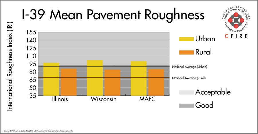
Infrastructure Condition
The International Roughness Index (IRI) measures the cumulative amount of vertical deviation (the bumpiness or roughness) for each segment of road, and is reported as a ratio in inches per mile. IRI values less than 95 are generally considered good, while values between 95 and 170 are generally considered acceptable. Since only corridor segments with reported IRI values from the 2011 HPMS dataset were considered in this analysis, some states may be missing from certain corridors.
The IRI is used as a measurement to determine infrastructure conditions within the Highway Performance Monitoring System (HPMS) such as pavement deterioration, pavement condition trends, cost allocation studies, and other analytical purposes. It is reported, at a minimum, for all road segments that fall under the Full Extent classification which includes the National Highway System (NHS), all principal arterials (interstates, freeways, and expressways), and rural minor arterials within the Sample Panel dataset. The data is collected by the states and submitted to the FHWA. The FHWA verifies the data, and houses it within the HPMS. For more historical information, see MnDOT’s Introduction to the International Roughness Index.
Freight Facilities
Intermodal terminals
- Union Pacific (UP) Global III in Rochelle, IL. Lifts <200,000 per year.
Major Rail Yards
- Global III in Rochelle, IL.
- Stevens Point, WI
Airports
- Chicago/Rockford International (RFD)
Automotive Distribution Centers
- Belvidere Assembly Plant: Belvidere, IL (UP)
- Mitsubishi Motors: Normal, IL (Norfolk Southern
Freight Rail
There are a number of Class I railroads and shortlines that are found in this corridor. In Wisconsin, the Canadian Pacific’s M&P Subdivision is a very light density line, carrying less than 5 million gross tons (MGT). There are two high-density (>100 MGT) routes that intersect the I-39 corridor: the Union Pacific Geneva Subdivision at Rochelle, IL and the BNSF Chillicothe Subdivision south of Wenona, IL. The rest of the lines have lower volumes according to the 2010 rail density data available from the 2013 National Transportation Atlas Database.
Passenger Rail
There are four passenger services that intersect the I-39 corridor:
- Empire Builder (Chicago to Seattle with a station in Portage, Wisconsin. Operates over the Canadian Pacific (CPR) Watertown Subdivision.
- Carl Sandburg/Illinois Zephyr with a station in Mendota, IL. Operates over the BNSF Mendota Subdivsion.
- Lincoln Service (Chicago to St. Louis) and the Texas Eagle (Chicago-San Antonio) operate over the Union Pacific Joliet Subdivision, with a station in Bloomington-Normal. Although this is a shared-use corridor, there are plans to build a second mainline dedicated to freight. This is the first route in the Midwest to test speeds of 110-mph.
Airports
There is one air cargo airport that services the I-39 corridor.
RFD is located in Rockford, IL. In terms of landed weight for 2012, RFD ranked as the 6th highest air cargo airport within the MAFC region while 27th nationally. It is considered a primary hub airport, and is home to a UPS air cargo facility.
| Chicago/Rockford International (RFD) | |
| Cargo Facilities | |
| Cargo Terminals | |
| Number of Runways (max length) | |
| Warehouses & DCs within 5 / 10 miles | 5 / 11 |
| Air Cargo Businesses within Urban Area | 196 |
| 2011 Landed Weight (lbs.) | 888,721,860 |
| 2010 LandedWeight (lbs.) | 917,260,300 |
| Change (Percentage) | -3.11% |
| Intermodal Connectors (5 / 10 miles) | 0 / 0 |
Ports
There are no navigable waterways that directly serve as Marine Highway reliever routes for I-39 between Wausau, WI and Normal, IL. I-39 closely parallels the Wisconsin River in central Wisconsin, but this river is not equipped with navigation locks. The nearest commercial waterways to the east that could provide a freight reliever route is Lake Michigan (M-90)—Illinois River (M-55) route from Green Bay, WI to Oglesby or Peoria, IL. Other freight ports along this route include Manitowoc, Sheboygan, Milwaukee, Kenosha, and Racine in Wisconsin and Chicago and Joliet in Illinois. To the west, the Upper Mississippi River (M-94)—Illinois Riverway (M-55) connects Peoria, IL to the ports at Minneapolis, MN, St. Louis, MO, and numerous other smaller ports and terminals.

Freight Generators, Warehouses, and Distribution Centers
There are a total of 8,036 freight generators employing 140,498 people within three miles of the I-39 corridor, and a total of 17,716 freight generators employing 297,069 people within 10 miles of the corridor. If the extent of analysis focuses on the metropolitan statistical areas (MSAs) intersected by the I-39 corridor, there are a total of 22,879 freight generators employing 367,963 people. Within the MSAs, there are a total of 152 warehousing and distribution centers employing 3,246 people. Freight generators were determined by using the NAICS codes prescribed for freight-related sectors in NCFRP Report 19, and include agriculture, mining, manufacturing, wholesale trade, retail trade, transportation and warehousing, and eating and drinking places.
| Major Manufacturers | Major Distribution Centers |
|
|
References
- Interstate 39. Wikipedia.
- Wisconsin Long Truck Operators Map. Wisconsin Department of Transportation.
- FHWA Interstate Brief (2011). US Department of Transportation.