DRAFT
Moline, Illinois to Hillside, Illinois
Snapshot: Length: 258 miles | Length in MAFC: 258 miles | Intersecting Interstates: I-290, I-294, I-355, I-39, I-74, I-80
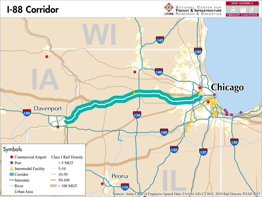
I-88 is located within Illinois where it runs from an interchange with I-80 near the Iowa border at the cities of Silvis and Moline to Hillside, near Chicago. It is part of the Chicago-Kansas City Expressway, which continues south where I-88 terminates at I-80.
I-88 is categorized as an emerging freight corridor by the MAFC regional freight study because of its importance as an alternative to I-80 for freight coming to Chicago from the west and also its status as part of the Chicago-Kansas City Expressway. The Quad Cities region at I-88’s western terminus is also a quickly developing economic center and is likely to benefit from its connection to Chicago via I-88.
For a significant portion of its route, I-88 is the Ronald Reagan Memorial Tollway. This toll road begins at Dixon in the west and travels all the way to the eastern terminus of I-88 in Hillside. Previously known as the East-West Tollway, it was renamed after the former president following his death in 2004. I-88 is an Illinois Department of Transportation Designated Truck Route.
Both Burlington Northern Santa Fe and Union Pacific have rail routes which enter Chicago from the West along a somewhat similar route to I-88. In order to reach the Union Pacific line however, BNSF’s line must be utilized and Iowa Interstate railroad must be used to get from Moline to Union Pacific’s tracks.
There are no water routes that directly parallel I-88.
Between Moline and Hillside, I-88 passes through Sterling, Dixon, Rochelle, Dekalb, Aurora, Naperville and Downers Grove, Illinois.
Metropolitan Statistical Areas Economic Profile
| MSA | Population | GDP (2011, in millions) | Employment | Freight-related Employment | Metropolitan Planning Organizations |
| Quad Cities (IL-IA) | 379,690 | $18,311 | 195,502 | 84,353 | Bi-State Regional Commission |
| Chicago (IL) | 9,461,105 | $547,609 | 4,333,730 | 1,706,242 | Chicago Metropolitan Agency on Planning |
National Connectors
Chicago, IL
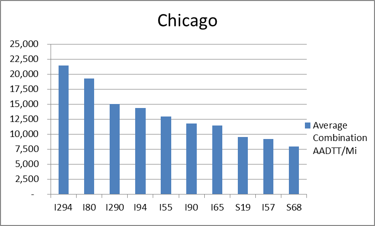
The interstates supporting freight originating in, destined for, and traveling through Chicago includes I-55, I-57, I-88, I-89, I-90, and I-94. In total, Chicago has 42 urban interstates, freeways, and expressways that support freight movements. Chicago’s geographic location as a crossroad of numerous interstates causes a dispersion of freight throughout a large network of national connectors and interstates that travel through the city. The average combination AADTT per mile on Chicago’s urban interstates, freeways, and expressways is over 10,000 trucks for seven roadways and nearly 20,000 combination trucks for two roadways.
Freight Projects Impacting Truck Traffic
There are no major projects taking place on I-88.
Truck Traffic
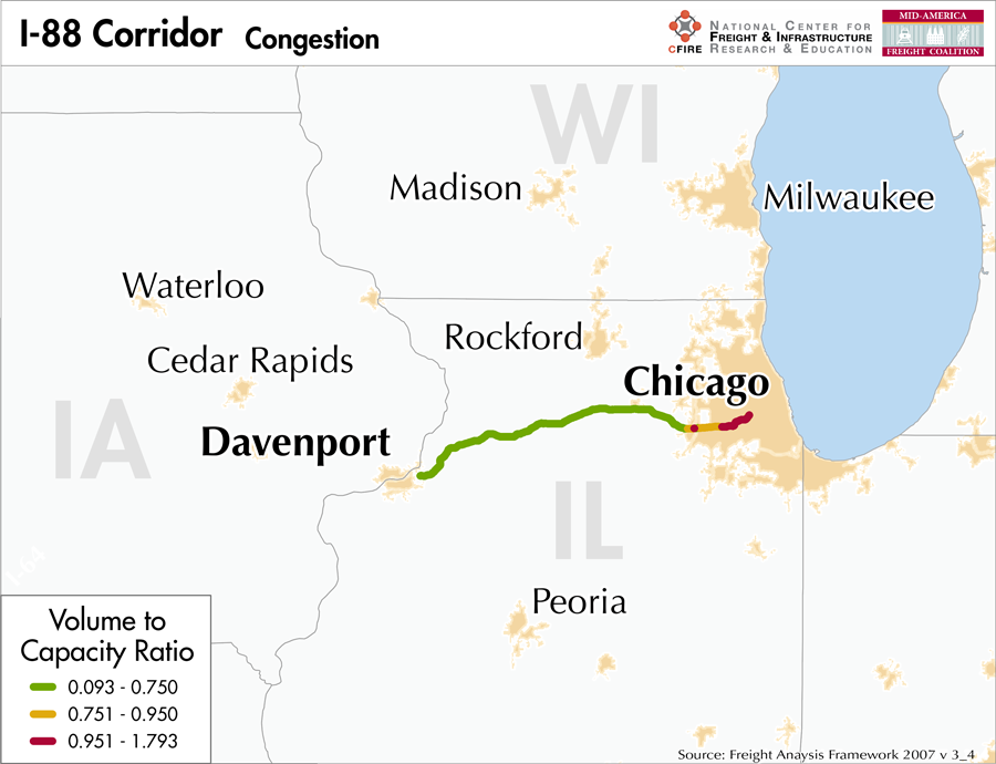
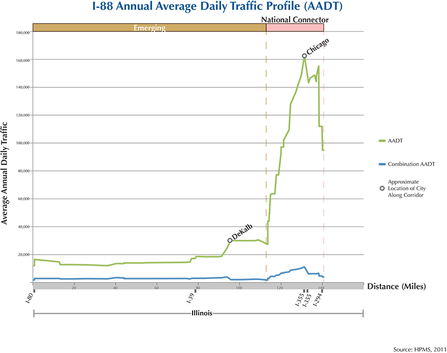
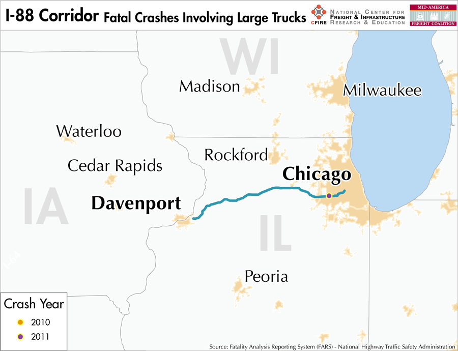
I-88 is a 258-mile corridor that passes through one MAFC state: Illinois.
- VMT 2007: 4,795,956
- Truck VMT 2007: 679,532
- Percent Truck VMT: 14.17 percent
Operational Efficiency (ITS)
There are no cameras along the I-88 Corridor. Near the western end of this stretch of interstate, outside of the Davenport, IA urban area, there is one message board.
Illinois collaborates with Indiana, Ohio, and Kentucky through ITS Midwest. Additionally, the Illinois DOT participates in the ENTERPRISE Pooled Fund Study.
Greenhouse Gas Emissions
- Yearly tons of CO2 assuming 4 mpg: 520,00
- Yearly tons of CO2 assuming 7.5 mpg: 280,00
Methodology
- Data: Truck Counts (HPMS 2011)
- Assume 4 and 7.5 miles per gallon
- No control for level of service or elevation changes
- 22.3 lbs. of CO2 per gallon of diesel
Fuel and Truck Parking
| There are 2 fueling stops that also offer truck parking along I-88. Zero truck stops have less than 25 parking stops, 2 have between 25-84 spots, and 0 have 85+ spots of parking capacity. Compressed Natural Gas (CNG) and Liquified Natural Gas (LNG) stations are listed to the right. | I-88 | CNG | LNG |
| Public | 0 | 0 | |
| Private | 1 | 0 | |
| Planned | 0 | 0 | |
| Total | 1 | 0 |
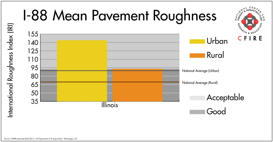
Infrastructure Condition
The International Roughness Index (IRI) measures the cumulative amount of vertical deviation (the bumpiness or roughness) for each segment of road and is reported as a ratio in inches per mile. IRI values less than 95 are generally considered good, while values between 95 and 170 are generally considered acceptable. Since only corridor segments with reported IRI values from the 2011 HPMS dataset were considered in this analysis, some states may be missing from certain corridors.
The IRI is used as a measurement to determine infrastructure conditions within the Highway Performance Monitoring System (HPMS) such as pavement deterioration, pavement condition trends, cost allocation studies, and other analytical purposes. It is reported, at a minimum, for all road segments that fall under the Full Extent classification which includes the National Highway System (NHS), all principal arterials (interstates, freeways, and expressways), and rural minor arterials within the Sample Panel dataset. The data is collected by the states and submitted to the FHWA. The FHWA verifies the data and houses it within the HPMS. For more historical information, see MnDOT’s Introduction to the International Roughness Index.
Freight Facilities
Intermodal Terminals
- Union Pacific (UP) Global III in Rochelle, Il. TOFC-COFC (<200,000 lifts/yr.)
- BNSF Willow Springs, Hodgkins, IL: TOFC-COFC (<60,000 lifts/yr.)
Major Rail Yards
- Proviso Yard
- Bensenville
Airports
- Chicago O’Hare International (ORD)
- Chicago/Rockford International (RFD)
Ports
- Port of Chicago
Freight Rail
The Union Pacific Geneva Subdivision parallels the corridor for about seventy percent of the corridor. This corridor is referred to as the Central Corridor, the key spine to Union Pacific’s network. This is one of the highest volume routes in the country with volumes greater than 100 million gross tons (MGT) per year in 2010 (1). The BNSF Barstow and Chicago Subdivision parallel the remaining thirty percent. It is also a shared-use corridor for a small segment from Chicago to Aurora.
Emerging Intermodal
Union Pacific’s Global III at Rochelle was completed in 2003 and it was the first intermodal terminal to be sited beyond Chicago. While the intermodal terminal is operating well below its capacity, the location has attracted multiple businesses to the logistics park related to frac sand mining.
The Harvey Intermodal Facility operated by Canadian National is being expanded by 500 acres to create a logistics park which will be located near I-80.
Passenger Rail
A small segment of the following services are within the I-88 corridor and operate over the same alignment: Southwest Chief (Chicago-Los Angeles), California Zephyr (Chicago-Northern California) Illinois Zephyr/Carl Sandburg (Chicago-Quincy). The station located within the I-88 is at Naperville. From Downtown Chicago to Aurora, the volume of freight that travels on this line was between 60-99 million gross tons (MGT) in 2010 (1).
Airports
There are two air cargo airports that service the I-88 corridor.
- ORD in Chicago is the 3rd ranked air cargo airport in the MAFC region and ranked 6th nationally in terms of 2012 landed cargo weight. UPS and FedEx air cargo facilities are both present at ORD, and it is considered a primary hub airport.
- RFD in Rockford is considered a primary hub airport. In 2012 Rockford ranked 6th within the MAFC region for landed weight, and 27th nationally. UPS has air cargo facilities at RFD.
| Chicago O’Hare International (ORD) | Chicago/Rockford International (RFD) | |
| Cargo Facilities | Mechanical Handling, Heated Storage, Air-Conditioned Storage, Refrigerated Storage, Deep Freeze Storage, Mortuary, Animal Quarantine, Fresh Meat Inspection, Health Officials, X-Ray Equipment, Decompression Chamber, Security for Valuables, Dangerous Goods, Radioactive Goods, Very Large/Heavy Cargo, Express/Courier Centre Cargo; Handling Agents:Evergreen/EAGLE, Servisair/GlobeGround | |
| Cargo Terminals | 15 | |
| Number of Runways (max. length) | 5 (12,998 feet) | |
| Warehouses & DCs within 5/10 miles | 27 / 56 | 5 / 11 |
| Air Cargo Businesses within Urban Area | 3339 | 196 |
| 2011 Landed Weight (lbs.) | 4,368,420,500 | 888,721,860 |
| 2010 Landed Weight (lbs.) | 4,895,940,100 | 917,260,300 |
| Change (Percentage) | -10.77% | -3.11% |
| Intermodal Connectors (5/10 miles) | 7 / 28 | 0 / 0 |
Ports
The Illinois River (M-55) and the Upper Mississippi River (M-94) together create an alternative Marine Highway reliever route to I-88 between Chicago, IL and Moline, IL. However, this route would be extremely indirect, requiring navigation south to St. Louis, MO and a return trip north.

Freight Generators, Warehouses, and Distribution Centers
There are a total of 6,455 freight generators employing 128,742 people within three miles of the I-88 corridor, and a total of 24,592 freight generators employing 406,759 people within 10 miles of the corridor. If the extent of analysis focuses on the metropolitan statistical areas (MSAs) intersected by the I-88 corridor, there are a total of 118,233 freight generators employing 1,790,595 people. Within the MSAs, there are a total of 371 warehousing and distribution centers employing 6,686 people. Freight generators were determined by using the NAICS codes prescribed for freight-related sectors in NCFRP Report 19, and include agriculture, mining, manufacturing, wholesale trade, retail trade, transportation and warehousing, and eating and drinking places.
References
- 2012 Illinois State Rail Plan. Illinois Department of Transportation, 2012.
- FHWA Interstate Brief (2011). US Department of Transportation.