DRAFT
Western Iowa to Eastern Ohio
Snapshot: Length: 3,073 miles | Length in MAFC: 442 miles | Intersecting Interstates: I-5, I-15, I-25, I-35, I-55, I-65, I-75, I-80, I-81, I-95
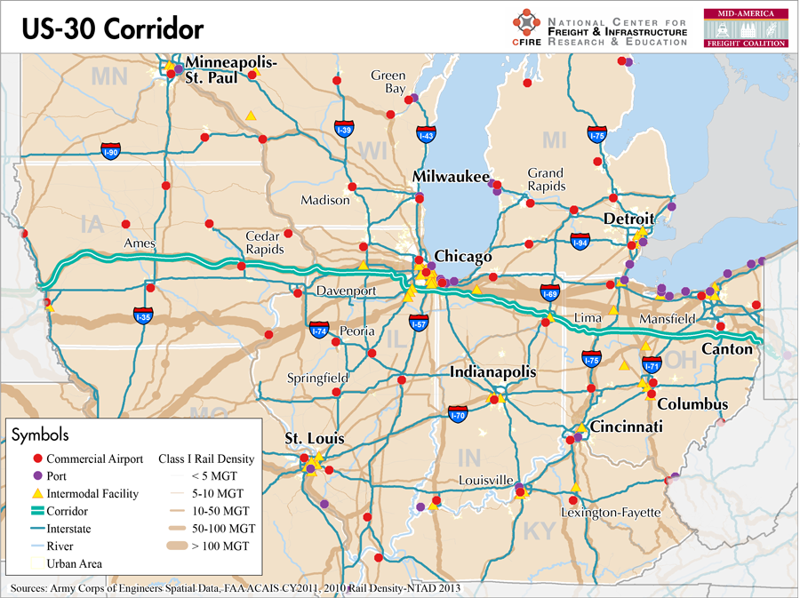
US-30 is a main east-west route across the MAFC. In the MAFC, US-30 spans Iowa, Illinois, Indiana, and Ohio. The major freight corridor portions of this route are found between I-57 in Illinois and I-71 in Ohio. Nationwide the corridor travels through Oregon, Idaho, Wyoming, Nebraska, Iowa, Illinois, Indiana, Ohio, West Virginia, Pennsylvania, and New Jersey. Much of the historic Lincoln Highway became part of US-30 (1).
With its major east-west connections to I-57, I-65, I-69, and I-75 this corridor provides an important connector route among the various automobile suppliers and manufactures that are located in this region.
The US-30 corridor qualifies as a Tier 2 corridor in the MAFC nationally significant freight corridor network due to its truck volumes and pronounced connections to other interstates and manufacturing facilities. The corridor meets the MAFC criteria only on the section of the facility from I-57 in Chicago, to just west of I-71 in Ohio. The concentration of businesses and industries along the north-south routes in this region further emphasize the importance of this corridor.
In Illinois, US-30 is not listed on the designated truck route list. In Indiana, US-30 is listed as a Commerce Corridor (2). For truck movements, InDOT provides bridge clearance maps and extra heavy duty highway map for corridors that allow up to 134,000 lbs (3,4). In Ohio, US-30 is listed on the macro-corridors map where 94 percent of all of Ohio’s freight movement occurs (5).
US-30 is not a toll facility in the MAFC region. Regarding parallel available service, in Indiana and Ohio, rail service is available on parallel tracks but marine service replication for the east-west route is not available.
In its entirety, US-30 connects Astoria, Oregon to Atlantic City, New Jersey. In the MAFC region, US 30 connects the communities and urban areas of Chicago, then Gary, Indiana, and Plymouth and For Wayne Indiana. In Ohio, the route connects to Bucyrus, Mansfield and Canton before crossing into Pennsylvania.
Metropolitan Statistical Areas Economic Profile
| MSA | Population | GDP (2011, in millions) | Employment | Freight-related Employment | Metropolitan Planning Organizations |
| Chicago (IL) | 9,461,105 | $547,609 | 4,333,730 | 1,706,242 | Chicago Metropolitan Agency on Planning |
| Michigan City-La Porte (IN) | 111,467 | $3,671 | 49,115 | 21,084 | Northwestern Indiana Regional Planning Commission |
| Fort Wayne (IN) | 416,257 | $18,278 | 222,219 | 97,758 | Northeastern Indiana Regional Coordinating Council |
| Lima (OH) | 106,331 | $4,865 | 60,756 | 25,712 | Lima-Allen County Regional Planning Commission |
| Mansfield (OH) | 124,475 | $3,580 | 60,453 | 29,947 | Richland County Regional Planning Commission |
| Canton-Massillon (OH) | 404,422 | $13,193 | 204,844 | 91,301 | Stark County Regional Planning Commission |
National Connectors
Chicago, IL
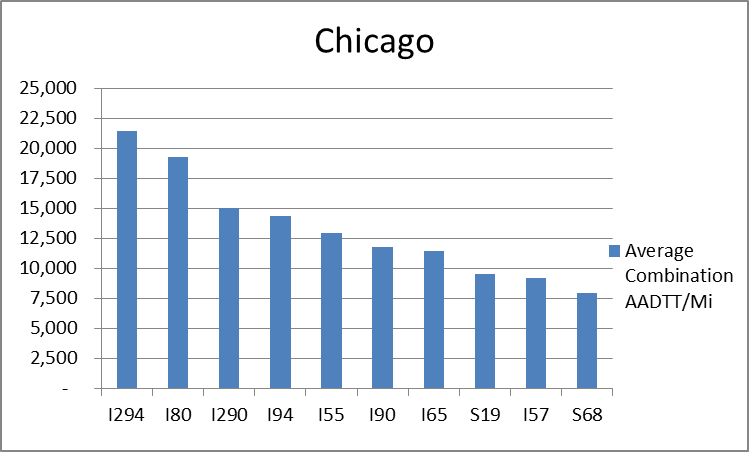
The interstates supporting freight originating in, destined for, and traveling through Chicago includes I-55, I-57, I-88, I-89, I-90, and I-94. In total, Chicago has 42 urban interstates, freeways, and expressways that support freight movements. Chicago’s geographic location as a crossroad of numerous interstates causes a dispersion of freight throughout a large network of national connectors and interstates that travel through the city. The average combination AADTT per mile on Chicago’s urban interstates, freeways, and expressways is over 10,000 trucks for seven roadways and nearly 20,000 combination trucks for two roadways.
Freight Projects Impacting Truck Traffic
Currently US 30 from I-57 to just east of I-75 has no major construction but has recently completed multi-lane sections and additional studies are underway to upgrade the facility east of I-77.
Truck Traffic
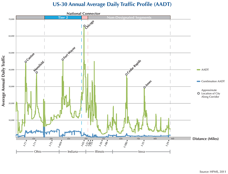
US-30 is a 442-mile corridor that crosses four states in the MAFC: Iowa, Illinois, Indiana, and Ohio.
- VMT 2007: 10,793,355
- Truck VMT 2007: 2,494,502
- Percent Truck VMT: 23.1 percent


Operational Efficiency (ITS)
Across the US-30 corridor, there are relatively few message boards (6) and cameras (3). Of the six message boards located along the corridor, five are found in Iowa, with the remaining message board located in Indiana, just east of the Chicago urban area. Two of the cameras found along the US-30 corridor are in Canton, and one is located to the east of Chicago in Indiana.
Iowa collaborates with Kansas, Missouri, Nebraska, and Oklahoma through IT Heartland, whereas Illinois, Indiana, and Ohio partner with Kentucky as part of IT Midwest. Additionally, the Iowa and Illinois DOTs participate in the ENTERPRISE Pool Fund Study.
Greenhouse Gas Emissions
- Yearly tons of CO2 assuming 4 mpg: 1,100,000
- Yearly tons of CO2 assuming 7.5 mpg: 600,000
Methodology
- Data: Truck Counts (HPMS 2011)
- Assume 4 and 7.5 miles per gallon
- No control for level of service or elevation changes
- 22.3 lbs. of CO2 per gallon of diesel
Fuel and Truck Parking
| The data set used to determine truck parking along interstates did not include US highways. Therefore, there are no data on truck parking for US-30. Compressed Natural Gas (CNG) and Liquified Natural Gas (LNG) stations are listed to the right. | US-30 | CNG | LNG |
| Public | 2 | 0 | |
| Private | 0 | 0 | |
| Planned | 0 | 0 | |
| Total | 2 | 0 |
Infrastructure Condition
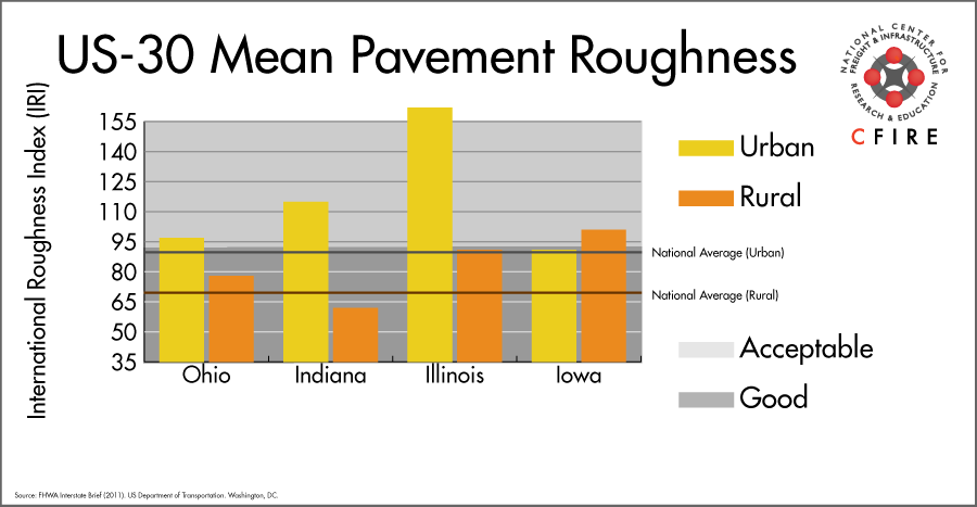
The International Roughness Index (IRI) measures the cumulative amount of vertical deviation (the bumpiness or roughness) for each segment of road and is reported as a ratio in inches per mile. IRI values less than 95 are generally considered good, while values between 95 and 170 are generally considered acceptable. Since only corridor segments with reported IRI values from the 2011 HPMS dataset were considered in this analysis, some states may be missing from certain corridors.
The IRI is used as a measurement to determine infrastructure conditions within the Highway Performance Monitoring System (HPMS) such as pavement deterioration, pavement condition trends, cost allocation studies, and other analytical purposes. It is reported, at a minimum, for all road segments that fall under the Full Extent classification which includes the National Highway System (NHS), all principal arterials (interstates, freeways, and expressways), and rural minor arterials within the Sample Panel dataset. The data is collected by the states and submitted to the FHWA. The FHWA verifies the data and houses it within the HPMS. For more historical information, see MnDOT’s Introduction to the International Roughness Index.
Freight Facilities
Intermodal Terminals
- Norfolk Southern (NS) Triple Crown RoadRailer – Fort Wayne, IN
Airports
- Fort Wayne International (FWA)
Ports
- Port of Indiana – Burns Harbor
- Port of Gary
- Port of Chicago
Freight Rail
The US-30 corridor is a multimodal corridor. There are a number of freight railroads which run parallel to US-30. The line density ranges from five to fifty million gross tons (MGT) per year according to 2010 rail density data from the 2013 National Transportation Atlas Database. The parallel network begins near Matteson, IL (Canadian National) to South Bend. The shortline Chicago, Fort Wayne and Eastern Railroad (CFE) runs from South Bend through Fort Wayne and then to Mansfield. Norfolk Southern and CSX have lines that cross this corridor.
Passenger Rail
The Cardinal/Hoosier State service (New York-Washington DC-Cincinnati-Indianapolis-Chicago operating over the CSX railroad intersects the US-30 corridor with a station in Dyer, IN. The CSX line segment that crosses this corridor carries less than five MGT per year.
Airports
There is one air cargo airport that services the US-30 corridor.
FWA in Fort Wayne is the lone primary hub airport along the US-30 corridor. It ranked 21st in terms of 2012 landed weight within the MAFC region. Nationally, it ranked 91st in 2012. UPS and FedEx Express both have air cargo facilities at FWA.
| Fort Wayne International (FWA) | |
| Cargo Facilities | Warehouse 26 600m² (286 320sq ft), 12x 747 Freighter Docks, Free Port/Foreign Trade Zone, Very Large/Heavy Cargo, Express/Courier Centre, 32 acre Air Apron with direct access to Warehouse, Handling Equipment |
| Cargo Terminals | 1 |
| Number of Runways (max. length) | 3 (12,001 feet) |
| Warehouses & DCs within 5/10 miles | 3 / 17 |
| Air Cargo Businesses within Urban Area | 152 |
| 2011 Landed Weight (lbs.) | 169,772,460 |
| 2010 Landed Weight (lbs.) | 170,959,305 |
| Change (Percentage) | -0.69% |
| Intermodal Connectors (5/10 miles) | 0 / 3 |
Ports
Both M-90/Erie Canal/M-87 and M-70 could serve as Marine Highway reliever routes to US-30 in the eastern United States. M-90/Erie Canal/M-87 provides navigable water access from Duluth, MN and Chicago, IL to New York/ New Jersey. M-90 includes all four upper Great Lakes and connects to the Atlantic seaboard via the St. Lawrence Seaway or the Erie Canal/the Hudson River (M-87). Freight currently moving via US-30 could by-pass some or all of US-30 as far as west as Chicago depending on proximity to Great Lakes ports. M-90 Great Lakes ports closest to US-30 are in the western Ohio port cluster from Cleveland, OH to Toledo, OH and the southern Lake Michigan port cluster from Burns Harbor, IN to Chicago, IL. Shipments needing to travel west of Chicago could continue by river barge via M-55/western M-70 as far as Kansas City, MO or rejoin US-30 at Council Bluffs, IA using M-29. Alternatively, freight currently moving via US-30 between Kansas City, MO and Pittsburgh, PA could access M-70 at major ports in Kansas City, MO; St. Louis, MO; Mt. Vernon; IN; Louisville, KY; Cincinnati, OH; Huntington Tri-State; Pittsburgh, PA; or any of the numerous smaller ports and terminals.

Freight Generators, Warehouses, and Distribution Centers
There are a total of 13,104 freight generators employing 241,747 people within three miles of the US-30 corridor, and a total of 31,848 freight generators employing 509,360 people within 10 miles of the corridor. If the extent of analysis focuses on the metropolitan statistical areas (MSAs) intersected by the US-30 corridor, there are a total of 127,230 freight generators employing 1,972,044 people. Within the MSAs, there are a total of 404 warehousing and distribution centers employing 8,985 people. Freight generators were determined by using the NAICS codes prescribed for freight-related sectors in NCFRP Report 19, and include agriculture, mining, manufacturing, wholesale trade, retail trade, transportation and warehousing, and eating and drinking places.
Major Manufacturers |
Major Distribution Centers |
|
|
References
- U.S. Route 30. Wikipedia.
- 2030 Long Range Transportation Plan. Indiana Department of Transportation.
- Maps. State of Indiana Website.
- Indiana Extra Heavy Duty Highways Map. Indiana Department of Transportation.
- Ohio Macro Corridor Highway System Map. Ohio Department of Transportation.
- FHWA Interstate Brief (2011). US Department of Transportation.