The US Marine Transportation System (MTS) is a catchall term for the approximately 25,000 miles of internal and coastal domestic waterways maintained for commercial navigation. The MTS can be thought of as two subsystems: the Inland Waterway System (IWS) and deep-water international waterways. The IWS consists of 12,000 miles of internal river and shallow (authorized depth of 9-14 feet) coastal waterways carrying shallow draft commercial vessels, typically barges. The remaining 13,000 miles of the MTS consist of deep-water oceanic coastal and Great Lakes harbors and waterways (those with authorized depth of 14 feet or greater; more typically 27 feet or greater).
The MAFC region has extensive access to both systems. The Mississippi River System (MRS)—including all navigable tributaries such as the Missouri, Ohio, Illinois, and Tennessee Rivers—is part of the IWS. All MAFC states except Michigan have direct access to the MRS. The US Great Lakes Navigations System (GLNS) is part of the greater international Great Lakes-St. Lawrence Seaway (GLSLS), an international waterway classified as a deep waterway on par with oceanic coastal ports for purposes of funding. Six of the ten MAFC states have commercial access to one or more of the Great Lakes, and six of the eight US states with Great Lakes access are in the MAFC region.
Both waterways connect ports in the middle of the North American continent to oceanic ports outside the region and throughout the world. Based on 2013 National Transportation Atlas Database, in the ten MAFC states there are 3,193 maritime facilities: 2,387 docks, 92 locks and dams, 49 fleeting areas, and close to 700 unclassified facilities. Across the entire United States there are 22,873 total facilities: 12,947 docks, 234 locks and dams, 116 fleeting areas, and nearly 10,000 unclassified facilities. The MAFC region has slightly more than 18 percent of the total ports in the United States and more than 39 percent of the nation’s lock and dams. Partly a reflection of undersized lock systems that require tow-size adaptations, and also a reflection of the inland river tow-building process, the inland river feeder system in the MAFC region contains more than 42 percent of the fleeting areas in the United States.
Figure 1: Inland Waterway System in the Mid-America Region
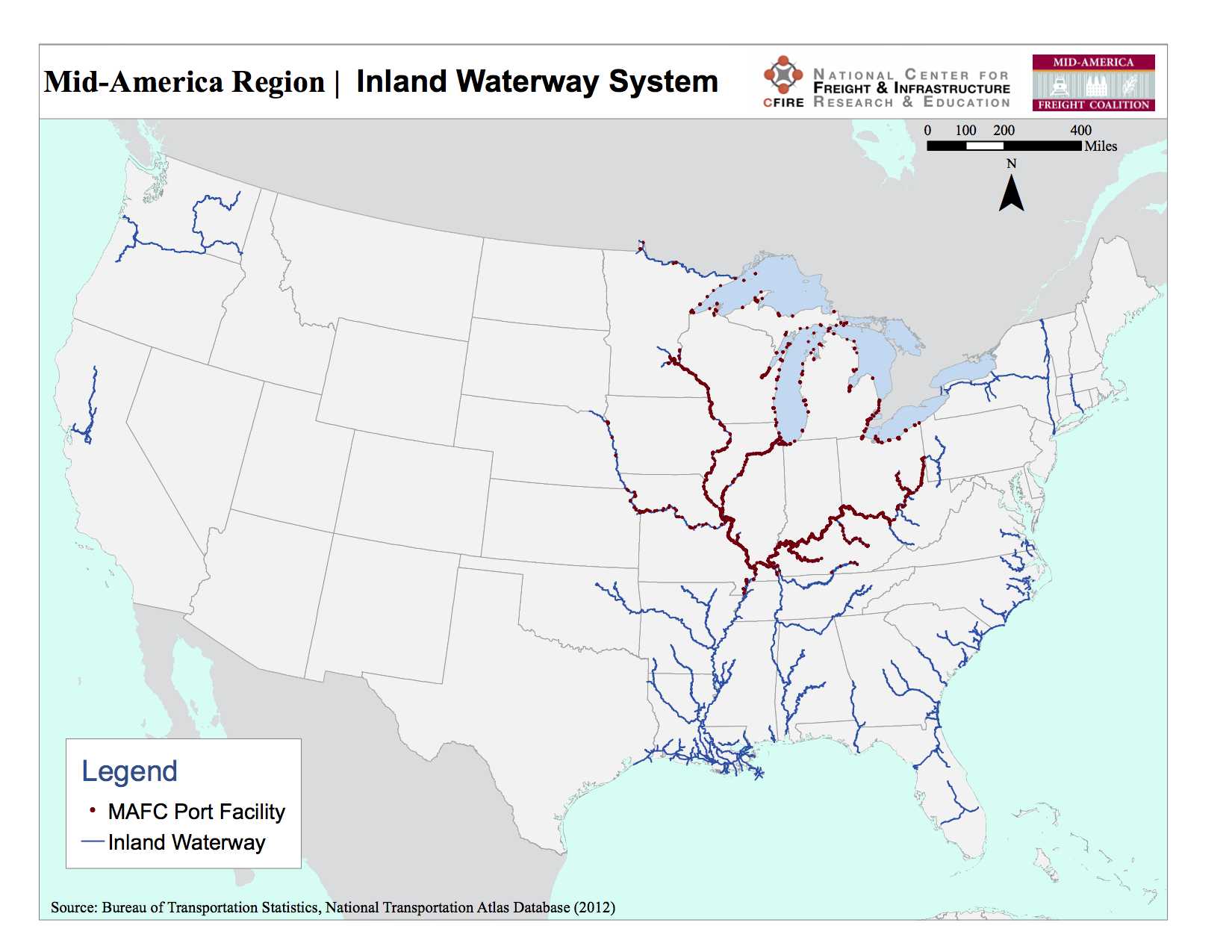 Table 1 summarizes the extent and infrastructure of the MTS waterways under federal jurisdiction. The US Army Corps of Engineers (USACE) is the principal federal agency charged with maintaining most of the channel and harbor infrastructure in both waterway systems. The federal funding for construction and maintenance of infrastructure in the IWS comes partly from general revenue from the US Treasury and partly from Inland Waterway Fuel Tax levied on commercial vessels using the IWS. Federal funding for maintenance of navigation infrastructure in the 13,000 miles of deep-water coastal channels and ports (including GLNS) is derived primarily from a Federal Harbor Maintenance Tax on the value of imported and domestic cargo handled at the ports. Construction and expansion of deep-water ports and channels funded by a combination of federal general purpose revenues and non-federal entities. A brief summary of evolution of the federal role in managing the US Marine Transportation System is found in Appendix A.
Table 1: Summary Statistics of the Marine Transportation System
| Total Domestic Marine Transportation System Waterways | 25,000 miles |
| Shallow Draft Inland Waterway System (including the Mississippi River System) | 12,000 miles |
| Deep Draft Navigation Routes and Ports (including Great Lakes) | 13,000 miles |
| Lock Sites | 191 |
| Lock Chambers | 236 |
| Harbors | 926 |
Source: Navigation: Did You Know?
The Mississippi River System (MRS) accounts for more than 6,000 miles, which is more than half of the IWS. The remainder consists of oceanic intercoastal waterways and shorter coastal rivers such as the Columbia River in the Pacific Northwest. The MRS consists not only of the Mississippi River Main Stem (Minnesota to Louisiana) but all of its major and minor navigable tributaries, including the Ohio River (Pennsylvania to the Mississippi River); the navigable portions of the Missouri River (from Sioux City, Iowa to the Mississippi River); the Illinois River Waterway (from Chicago to St. Louis) and all of the navigable tributaries of each. Because the majority of the 12,000-mile IWS is made up of rivers and shallow coastlines, much of the IWS requires periodic dredging of sediment to remain navigable. The US Army Corps of Engineers is authorized to maintain the entire IWS as shallow draft waterways with a minimum depth of 9-14 feet sufficient to accommodate barges.
Commercial navigation on the MRS also depends on a system of navigation locks and dams, reservoir dams to manage seasonal and annual variations in water levels, and levees to protect land adjacent to rivers from flooding and maintain navigable water depths. The MRS alone accounts for 138 of the nation’s 191 primary lock sites, and 70 of these are located in riverways within or adjacent to the MAFC region. The full extent of the MRS and Gulf Coast portions of the IWS are depicted in Figure 2. Maritime infrastructure and policy issues affecting the Mississippi River System (MRS) are discussed in greater detail in Appendix B.
Figure 2: The MRS and Gulf Coast Inland Waterway System
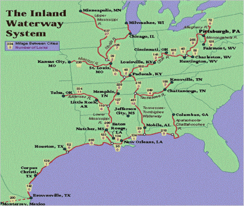
Source: The Potential of the COB All Water Delivery System
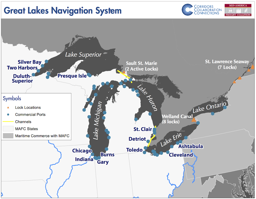
The 1,600-mile, US Great Lakes Navigation System (GLNS) (Figure 3) is part of the larger international 2,300 mile Great Lakes–St. Lawrence Seaway System (GLSLS) that reaches from Duluth, Minnesota to the Atlantic Ocean.
Six of the eight US states—Illinois, Indiana, Michigan, Minnesota, Ohio, and Wisconsin—abutting the Great Lakes are part of MAFC (Pennsylvania and New York are the others). The easternmost 700 miles of the GLSLS are primarily under Canadian jurisdiction, though the United States shares responsibility for two of the seven locks on the St. Lawrence Seaway. The GLNS provides the MAFC region with a deep-draft waterway that can accommodate freight vessels much larger than river barges but smaller than the largest ocean going container ships and tankers. It also provides the MAFC region with a direct water access to Canada and other foreign trade routes.
The authorized depth of Great Lakes channels and commercial ports is 27 feet, compared to depths of more than 45 feet or more at commercial ocean coastal ports. Unlike the IWS, the majority of deep water coastal and Great Lakes navigation routes—approximately 90 percent of GLNS routes according to the US Army Corps of Engineers—are naturally deep enough to accommodate commercial vessels with up to 26-foot drafts. However, lock and channel maintenance is required in the St. Marys River connecting Lake Superior to Lake Huron, and channel maintenance is required in the St. Clair River between Lake Huron to Lake Erie. Like most of their oceanic counterparts, the majority of Great Lakes commercial and recreational harbors, ports, and connecting channels also require substantial dredging and other harbor infrastructure. Maritime infrastructure and the policy issues related to the Great Lakes Navigation System are discussed in greater detail in Appendix C.
Figure 3: The Great Lakes Navigation System GLNS
Further Reading
- Volume of Maritime Freight in the MAFC Region
- Top Commodities by Waterway
- Maritime Freight Movement in the MRS and GLNS
- Value of Maritime Shipping
- Maritime Transportation Policy Issues