DRAFT
Joplin, Missouri to St. Louis, Missouri
Snapshot: Length: 634 miles | Length in MAFC: 290 miles | Intersecting Interstates: I-35, I-40, I-49, I-55
I-44 is a major east-west corridor beginning in Wichita Falls, TX outside of the MAFC region and terminating at St Louis, MO. I-44 traverses Texas and Oklahoma and terminates on the eastern border of Missouri at St Louis. The western terminus of I-44 is US-277, US-281, and US-287. On the eastern end, I-44 connects with I-55.
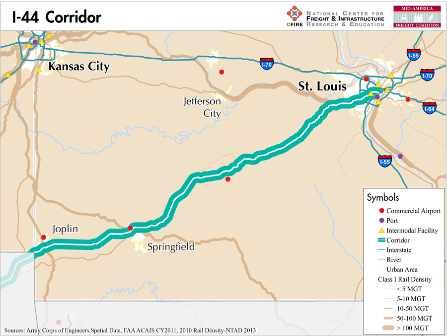
Much of I-44, especially along the Missouri portion of the corridor, replaced the historic Route 66 with upgrades to a four-lane facility before 1955. In Missouri, I-44 enters the state southwest of Joplin, MO near the corners of Oklahoma, Kansas, and Missouri. At Joplin, I-44 runs concurrent with the newly designated segment of I-49 (1).
The I-44 corridor is considered eligible for the MAP-21 Primary Freight Network and a Tier 1 corridor in the MAFC because of its high truck volumes in the MAFC and its links to the southwest United States and the St. Louis area. Both Joplin and Springfield, MO are not only major urban areas along the corridor; they have historically been known as the location of many truck fleets. Similarly, Joplin, MO has historic role in railroad and rail car maintenance. There is Class I rail available in close proximity along the entire length of the I-44 corridor in Missouri. There are no marine services parallel to I-44 in Missouri. I-44 is also part of Missouri’s designated highway network (2). Missouri provides a complete listing of OSOW constraints on I-44 on the Commercial Vehicle Restriction map (3).
I-44 is not tolled in Missouri but is tolled in Oklahoma as three different toll facilities: the Baily Turnpike, the Turner Turnpike and the Will Rogers Turnpike. There are also two major military bases along the I-44 corridor. In Texas I-44 provides access to Sheppard Air Force base and in Missouri I-44 provides access to the Ft. Leonard Wood Army base. After its origin in Wichita Falls, TX, I-44 passes through the major metropolitan areas of Oklahoma City, OK and Tulsa, OK. In Missouri it passes through Joplin, Springfield, Rolla, and terminates in St Louis.
Metropolitan Statistical Areas Economic Profile
| MSA | Population | GDP (2011, in millions) | Employment | Freight-related Employment | Metropolitan Planning Organizations |
| Joplin (MO) | 175,518 | $5,979 | 92,778 | 41,835 | Joplin Area Transportation Study Organization |
| Springfield (MO) | 436,712 | $15,387 | 230,104 | 91,411 | Ozarks Transportation Organization |
| St. Louis (MO-IL) | 2,787,701 | $132,029 | 1,338,018 | 502,178 | East-West Gateway Council of Governments |
National Connectors
St. Louis
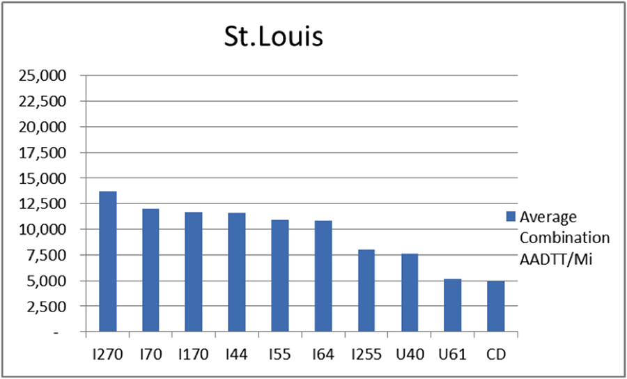
The interstates supporting freight originating in, destined for, and traveling through St. Louis are I-44, I-55, I-64, and I-70. In total, St. Louis has 35 urban interstates, freeways, and expressways that support freight movements. I-70 and its national connectors I-270 and I-170 are the top three freight-carrying roadways ranked by average combination AADTT per mile. In total I-70, I-170, and I-270 carry 36.4 percent of truck miles traveled on urban interstates, freeways, and expressways within St. Louis.
Freight Projects Impacting Truck Traffic
Missouri is placing a strong emphasis on ensuring the freight and passenger capacity of one of their most important interstate corridors. The I-44 Planning for Progress project will prepare the plans for major reconstruction of I-44 to accommodate growing freight traffic and improve safety and efficiency along the route. Planning is still at a relatively early stage.
Truck Traffic
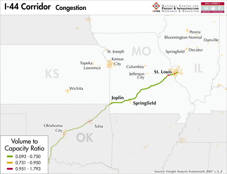
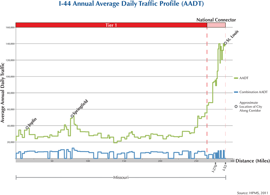
I-44 is a 290-mile corridor that crosses one state in the MAFC: Missouri.
- VMT 2007: 11,117,932
- Truck VMT 2007: 2,933,830
- Percent Truck VMT: 26.4 percent

Safety_Fatality_I44.pdf
Operational Efficiency (ITS)
Along the I-44 Corridor, both message boards (14) and cameras (31) are clustered around St. Louis. Of the 14 message boards found along this stretch of highway, 11 are found within the St. Louis city limits, while the remaining 3 are located less than 30 miles from urban boundary along I-44. This pattern is echoed in the distribution of cameras along the I-44 corridor, with 18 being found within the St. Louis city limits.
Missouri collaborates with Iowa, Kansas, Nebraska, and Oklahoma through ITS Heartland.
Greenhouse Gas Emissions
- Yearly tons of CO2 assuming 4 mpg: 2,800,000
- Yearly tons of CO2 assuming 7.5 mpg: 1,500,000
Methodology
- Data: Truck Counts (HPMS 2011)
- Assume 4 and 7.5 miles per gallon
- No control for level of service or elevation changes
- 22.3 lbs. of CO2 per gallon of Diesel
Fuel and Truck Parking
| There are 21 fueling stops that also offer truck parking along I-44. Two truck stops have less than 25 parking spots, 7 have between 25-84 spots and 12 have 85+ parking spots. Compressed Natural Gas (CNG) and Liquified Natural Gas (LNG) stations are listed to the right. | I-44 | CNG | LNG |
| Public | 2 | 0 | |
| Private | 0 | 0 | |
| Planned | 0 | 1 | |
| Total | 2 | 1 |
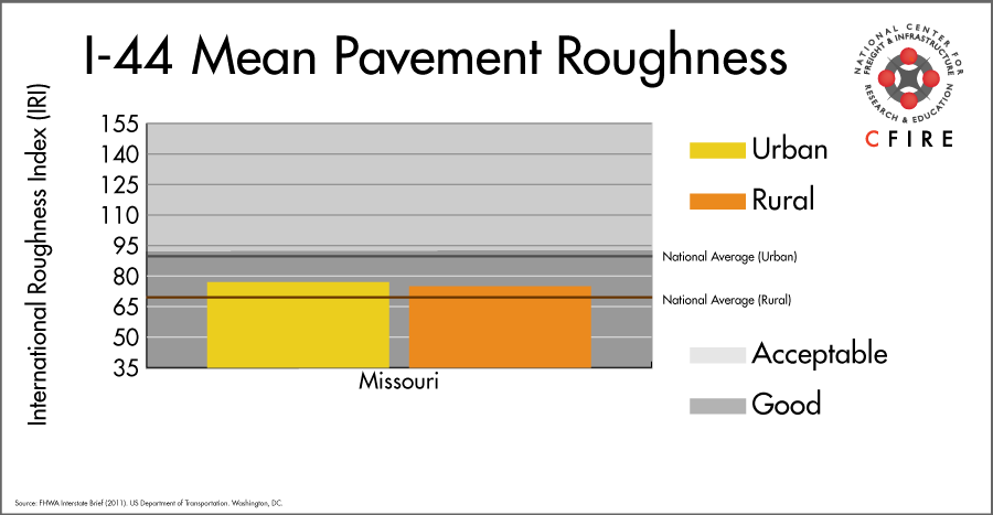
Infrastructure Condition
The International Roughness Index (IRI) measures the cumulative amount of vertical deviation (the bumpiness or roughness) for each segment of road, and is reported as a ratio in inches per mile. IRI values less than 95 are generally considered good, while values between 95 and 170 are generally considered acceptable. Since only corridor segments with reported IRI values from the 2011 HPMS dataset were considered in this analysis, some states may be missing from certain corridors.
The IRI is used as a measurement to determine infrastructure conditions within the Highway Performance Monitoring System (HPMS) such as pavement deterioration, pavement condition trends, cost allocation studies, and other analytical purposes. It is reported, at a minimum, for all road segments that fall under the Full Extent classification which includes the National Highway System (NHS), all principal arterials (interstates, freeways, and expressways), and rural minor arterials within the Sample Panel dataset. The data is collected by the states and submitted to the FHWA. The FHWA verifies the data, and houses it within the HPMS. For more historical information, see MnDOT’s Introduction to the International Roughness Index.
Freight Facilities
Intermodal Terminals
- Burlington Northern Santa Fe (BNSF)- Lindenwood- St. Louis: TOFC/COFC <70,000 lifts/year
Major Rail Yards
- Lindenwood, 23rd Street, and Tower Grove Yards: St. Louis
- Springfield Yard: Springfield
Airports
- Lambert – St. Louis International (STL)
- Springfield – Branson National (SGF)
Ports
- Port of St. Louis
Automotive Distribution Centers
- Valley Park Facility (BNSF) Fenton, MO I-44 @I-270
Freight Rail
Two Class I railroads can be found on this corridor. Union Pacific (UP) runs a high-density (>100 million gross tons -MGT) shared-use freight/passenger right of way for 37 miles. The BNSF Cuba Subdivision, a light density line (5-10 MGT), parallels I-44 from St. Louis, MO to Springfield, MO and is part of the intermodal route from St. Louis to Los Angeles, CA. In Springfield, a 50-100 MGT BNSF line runs south to Memphis, TN. From Springfield to the state line, two railroads cross the corridor: Missouri and North Arkansas Railroad Company and Kansas City Southern. The Burlington Junction Railway handles switching at the Valley Park Facility in Fenton.
Passenger Rail
Amtrak’s Missouri River Runner has daily round trip service from St. Louis to Kansas City, MO and runs parallel to I-44 for approximately 37 miles beginning in St. Louis. The line is primarily owned by Union Pacific but a small segment in St. Louis is owned by the Terminal Railroad Association of St. Louis (TRRA), a joint partnership of five Class I railroads: UP, BNSF, CN, CSX, and NS. This route is also a high-density freight route (> 100 MGT) line. The Missouri River Runner stations along I-44 are in St. Louis and in Kirkwood, MO.
Airports
There are two air cargo airports that service the I-44 corridor.
- STL in St. Louis, MO is the 14th ranked commercial airport in the MAFC region in terms of landed weight. Nationally, STL is ranked 61st. STL is considered a primary hub airport, and is serviced by both UPS and FedEx.
- SGF in Springfield, MO is the 18th ranked commercial airport in the MAFC region for landed weight, and is ranked 86th overall in the nation. It is also considered a primary hub airport, and is home to a UPS air cargo facility.
| Springfield-Branson National (SGF) | Lambert-St. Louis International (STL) | |
| Cargo Facilities | Capacity 4 479 700tonnes (9 875 946,000lbs), 2x 747 Freighter Docks, Bonded Warehouse, Free Port/Foreign Trade Zone, Aircraft Maintenance, Mechanical Handling, Heated Storage, Air-Conditioned Storage, Refrigerated Storage, X-Ray Equipment, Security for Valuables, Dangerous Goods, Radioactive Goods, Very Large/Heavy Cargo, Express/Courier Centre, New cargo facility development by Aeroterm of 22854 sq metres also available | |
| Cargo Terminals | 2 | |
| Number of Runways (max length) | 2 (7,998) | 4 (11,020 feet) |
| Warehouses & DCs within 5 / 10 miles | 5 / 17 | 15 / 41 |
| Air Cargo Businesses within Urban Area | 128 | 845 |
| 2011 Landed Weight (lbs.) | 189,744,897 | 384,332,870 |
| 2010 Landed Weight (lbs.) | 191,604,087 | 371,026,650 |
| Change (Percentage) | -0.97% | 3.59% |
| Intermodal Connectors (5 / 10 miles) | 1 / 1 | 2 / 7 |
Ports
There are no navigable waterways that directly serve as a Marine Highway reliever route for I-44. Freight shipped via I-44 between St. Louis, MO and points north of I-44 could use the western Missouri River (western M-70) and other roads. Freight shipped via I-44 between St. Louis, MO and points south of I-44 could use the Mississippi River (M-55) and other roads. Kansas City, MO is the largest M-70 port west of St. Louis. Southeast Missouri Port is the largest M-55 port in Missouri south of St. Louis. Several other smaller ports and terminals in Missouri between these larger ports provide potential access to the national inland Marine Highway system.

Freight Generators, Warehouses, and Distribution Centers
There are a total of 12,407 freight generators employing 217,427 people within three miles of the I-44 corridor, and a total of 27,100 freight generators employing 442,293 people within 10 miles of the corridor. If the extent of analysis focuses on the metropolitan statistical areas (MSAs) intersected by the I-44 corridor, there are a total of 41,710 freight generators employing 635,424 people. Within the MSAs, there are a total of 203 warehousing and distribution centers employing 5,573 people. Freight generators were determined by using the NAICS codes prescribed for freight-related sectors in NCFRP Report 19, and include agriculture, mining, manufacturing, wholesale trade, retail trade, transportation and warehousing, and eating and drinking places.
| Major Manufacturers | Major Distribution Centers |
|
|
References
- Interstate 44. Wikipedia.
- Missouri Vehicle Route Map: 2012-2013. Missouri Department of Transportation.
- Maps and Tools. Missouri Department of Transportation.
- FHWA Interstate Brief (2011). US Department of Transportation.