DRAFT
Iowa City, Iowa to Waterloo, Iowa
Snapshot: Length: 73 miles | Length in MAFC: 73 miles | Intersecting Interstates: I-80
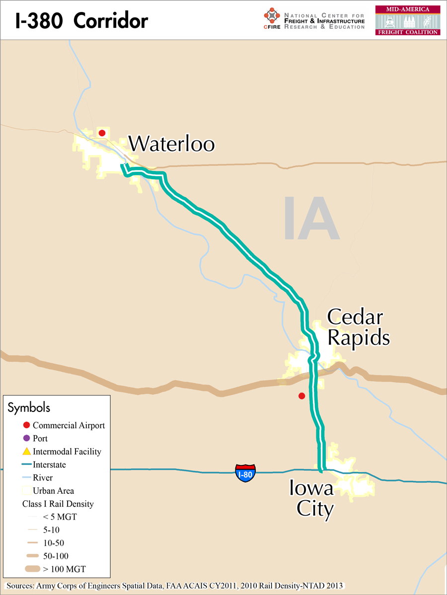
I-380 is an auxiliary north-south interstate in the eastern half of Iowa. I-380 begins at I-80 at Coralville/Iowa City and extends for 73 miles north to Waterloo, Iowa at the junction of US 20. Auxiliary interstates can be a spur, bypass or loop facility; I-380 is a spur (1). I-380 serves an agriculture based area in Iowa and also supports connections to a major interstate with I-80, and provides connections to several Iowa communities.
From the I-80 origination, I-380 runs north concurrently with US-218 and Iowa 27 to Cedar Rapids, Iowa. At Cedar Rapids, I-380 and Iowa 27 continue north towards Waterloo. At Waterloo, the route is rejoined by US -218 and US-218 and continues north while I-380 terminates in Cedar falls at the junction of Mitchell Street. Iowa-27 is designated as the Avenue of the Saints and as such runs concurrently as the Avenue of the Saints. Iowa’s portion of the Avenue contributes to the over 500 mile corridor from St Louis, Missouri to St Paul, Minnesota.
While portions of I-380 run concurrently with the Avenue of the Saints which is associated with the Mississippi River, there are no parallel marine system within immediate proximity. The Mississippi River is over 70 miles to the east but could provide duplicate service for the facility for products moving beyond the Iowa area. Parallel rail service is provided by the Iowa Northern Railway Company (IANR)(2). This corridor does provide freight service in support of the same movements facilitated by I-380. In 2011 the IANR moved over 16,000 carloads grain to facilities such as ADM and Cargill.
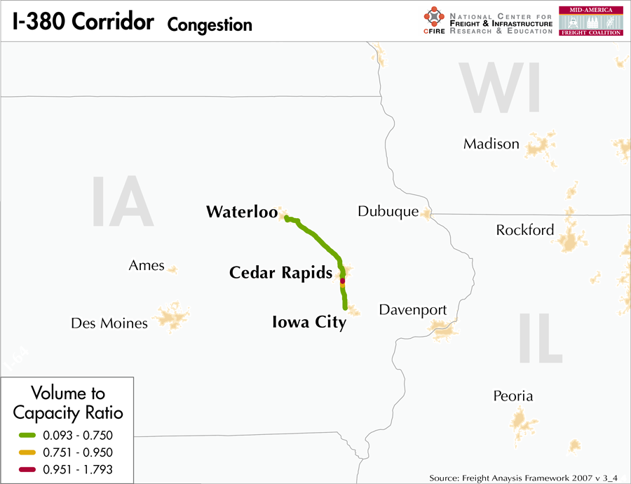
I-380 is considered an emerging freight corridor in the regional freight study based on daily truck volumes, and its status as a spur interstate. The corridor also provides an important connection between several Iowa communities and major freight and passenger corridors.
I-380 is not listed on the Iowa DOT restricted pavements or the bridge embargo map but is listed on vertical clearance list (3,4). I-380 is not a toll facility. The Cedar River and Iowa River, independently, and in association with the Missouri and Mississippi systems have inflicted major flooding in 1993 and 2008 and forced closure of the facility at the Iowa River.
The I-380 corridor connects the Iowa communities of Iowa City, Coralville, Cedar Rapids, and Waterloo. Nationally, as part of the Avenue of the Saints, I-380 provides a vital link between St Louis, Missouri and St Paul, Minnesota.
Metropolitan Statistical Areas Economic Profile
| MSA | Population | GDP (2011, in millions) | Employment | Freight-related Employment | Metropolitan Planning Organizations |
| Waterloo-Cedar Falls (IA) | 167,819 | $8,594 | 95,685 | 37,394 | Iowa Northland Regional Council of Governments |
| Cedar Rapids (IA) | 257,940 | $14,589 | 160,403 | 63,788 | Corridor MPO |
| Iowa City (IA) | 152,586 | $7,902 | 76,164 | 26,182 | MPO of Johnson County |
National Connectors
There are no national connectors on the I-380 corridor in the MAFC region.
Freight Projects Impacting Truck Traffic
At this time there do not appear to be any major projects being undertaken in the I-380 corridor outside of routine preservation and maintenance. Iowa DOT has recently completed the I-380 reconstruction project that replaced the pavement with 11.5 inch thick concrete and widening to a 14 foot driving lane and a 12 foot passing lane. The inside and outside shoulders and all safety devices were also reconstructed.
Truck Traffic
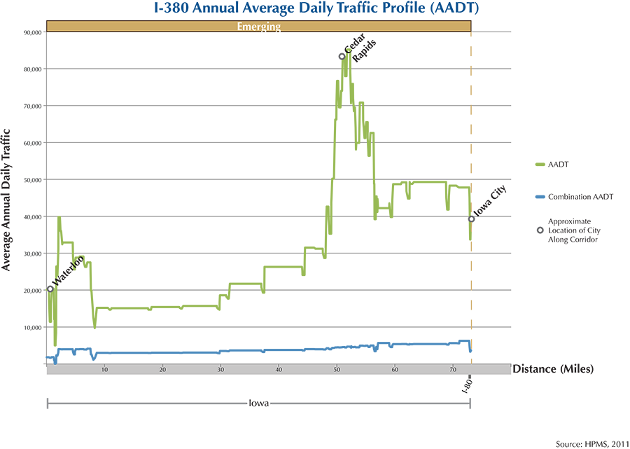
I-380 is a 73-mile corridor within one state in the MAFC: Iowa.
- VMT 2007: 2,156,302
- Truck VMT 2007: 480,026
- Percent Truck VMT: 22.26 percent
Operational Efficiency (ITS)
There are 12 message boards along the I-380 corridor. The majority (8) are located within 10 miles of Cedar Rapids, IA with smaller clusters surrounding Iowa City, IA (3) and Waterloo, IA (1). There are no cameras on the I-380 corridor.
Iowa collaborates with Kansas, Missouri, Nebraska, and Oklahoma through ITS Heartland. Additionally, the Iowa DOT participates in the ENTERPRISE Pooled Fund Study.
Greenhouse Gas Emissions
- Yearly tons of CO2 assuming 4 mpg: 290,000
- Yearly tons of CO2 assuming 7.5 mpg: 160,00
Methodology
- Data: Truck Counts (HPMS 2011)
- Assume 4 and 7.5 miles per gallon
- No control for level of service or elevation changes
- 22.3 lbs. of CO2 per gallon of diesel
Fuel and Truck Parking
| The data set used to determine truck parking along interstates did not include any three-digit interstates. Therefore, there are no data on truck parking for I-380. Compressed Natural Gas (CNG) and Liquified Natural Gas (LNG) stations are listed to the right. | I-380 | CNG | LNG |
| Public | 1 | 0 | |
| Private | 0 | 0 | |
| Planned | 0 | 0 | |
| Total | 1 | 0 |
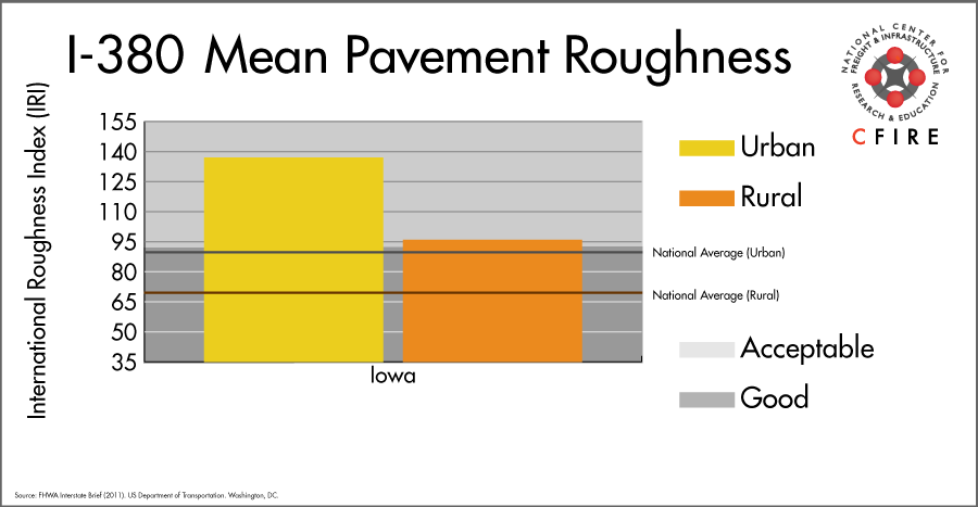
Infrastructure Condition
The International Roughness Index (IRI) measures the cumulative amount of vertical deviation (the bumpiness or roughness) for each segment of road and is reported as a ratio in inches per mile. IRI values less than 95 are generally considered good, while values between 95 and 170 are generally considered acceptable. Since only corridor segments with reported IRI values from the 2011 HPMS dataset were considered in this analysis, some states may be missing from certain corridors.
The IRI is used as a measurement to determine infrastructure conditions within the Highway Performance Monitoring System (HPMS) such as pavement deterioration, pavement condition trends, cost allocation studies, and other analytical purposes. It is reported, at a minimum, for all road segments that fall under the Full Extent classification which includes the National Highway System (NHS), all principal arterials (interstates, freeways, and expressways), and rural minor arterials within the Sample Panel dataset. The data is collected by the states and submitted to the FHWA. The FHWA verifies the data and houses it within the HPMS. For more historical information, see MnDOT’s Introduction to the International Roughness Index.
Freight Facilities
Major Rail Yards
- Waterloo Yards: Waterloo (CN & IANR)
- Bryant Yard: Cedar Rapids
- General Mills Yard: Cedar Rapids
Grain Facilities
- Waterloo
- La Porte
- Cedar Rapids
Ethanol Facilities
- Cedar Rapids
Airports
- The Eastern Iowa Airport (CID)
Freight Rail
Waterloo is a junction for a number of very light density lines, the heaviest being the Canadian National (CN) Dubuque Subdivision with approximately 12 million gross tons (MGT) in 2011 (5).
- The Union Pacific (UP) Clinton Subdivision is a high-density route that carries coal from the Powder River Basin in Wyoming to the Midwest. Over 130 MGT intersects the I-380 corridor in Cedar Rapids.
- The Cedar Rapids and Iowa City Railroad Company (CIC) runs parallel to I-380 from Cedar Rapids to Iowa City. CIC carries less than 1 MGT per year and serves the corn grinding facilities along the corridor and the ethanol plants in Cedar Rapids.
Passenger Rail
There is no passenger rail service on the I-380 corridor.
Airports
There is one air cargo airport that services the I-380 corridor.
CID in Cedar Rapids is the lone air cargo airport servicing the I-380 corridor. In 2012 it ranked 15th within the MAFC region in terms of landed weight, and 76th nationally. It is considered a primary hub airport and maintains air cargo facilities for both UPS and FedEx Express.
| The Eastern Iowa Airport (CID) | |
| Cargo Facilities | Capacity 36 325tonnes (80 082,000lbs), Bonded Warehouse, Free Port/Foreign Trade Zone, Express/Courier Centre |
| Cargo Terminals | 4 |
| Number of Runways (max. length) | 2 (8,602 feet) |
| Warehouses & DCs within 5/10 miles | 4 / 9 |
| Air Cargo Businesses within Urban Area | 133 |
| 2011 Landed Weight (lbs.) | 210,618,182 |
| 2010 Landed Weight (lbs.) | 206,621,220 |
| Change (Percentage) | 1.93% |
| Intermodal Connectors (5/10 miles) | 2 / 2 |
Ports
There are no navigable waterways that serve as a Marine Highway reliever route to I-380.

Freight Generators, Warehouses, and Distribution Centers
There are a total of 5,480 freight generators employing 94,115 people within three miles of the I-380 corridor, and a total of 13,782 freight generators employing 198,853 people within 10 miles of the corridor. If the extent of analysis focuses on the metropolitan statistical areas (MSAs) intersected by the I-380 corridor, there are a total of 7,715 freight generators employing 127,364 people. Within the MSAs, there are a total of 86 warehousing and distribution centers employing 997 people. Freight generators were determined by using the NAICS codes prescribed for freight-related sectors in NCFRP Report 19, and include agriculture, mining, manufacturing, wholesale trade, retail trade, transportation and warehousing, and eating and drinking places.
References
- Interstate 380 (Iowa). Wikipedia.
- Communities We Serve. Iowa Northern Railway Company.
- Iowa State Highway Map. Iowa Department of Transportation.
- Vertical Clearance Update. Iowa Department of Transportation.
- Railroad Traffic Density Map (2011). Iowa Department of Transportation.
- FHWA Interstate Brief (2011). US Department of Transportation.