DRAFT
Arkansas/Missouri Border to Chicago, Illinois
Snapshot: Length: 964 miles | Length in MAFC: 504 miles | Intersecting Interstates: I-10, I-20, I-40, I-44, I-64, I-70, I-80, I-90, I-94
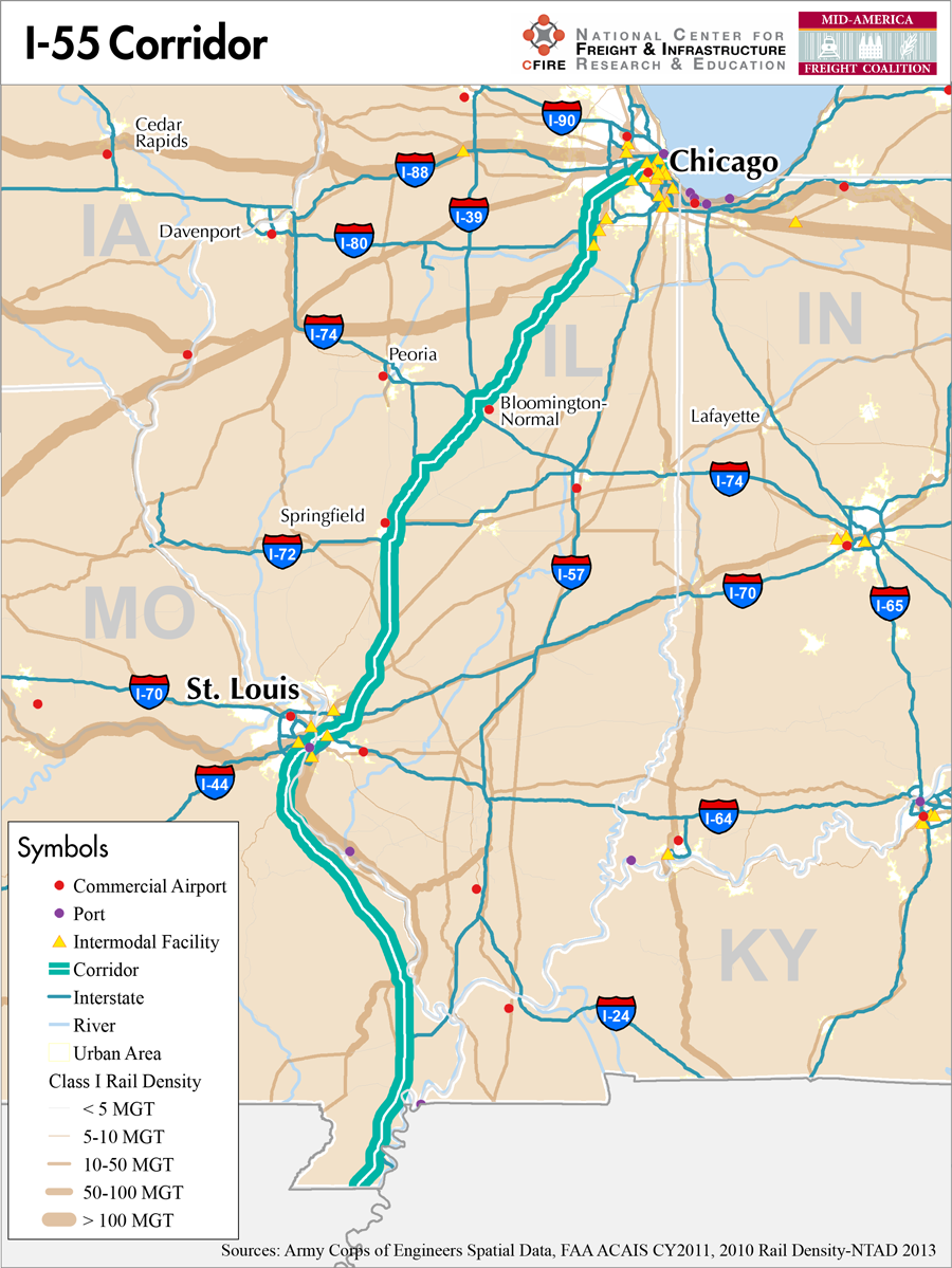
I-55 is major north-south route in the MAFC. I-55 begins in LaPlace, LA at I-10, traverses Mississippi, Tennessee, Arkansas, and enters Missouri in the southeastern corner. I-55 then travels north parallel to the Mississippi River to St Louis, MO. In St Louis, I-55 merges with I-44, crosses the Mississippi River with I-70 and I-64 and continues into Illinois. I-55 then travels northeasterly towards Chicago and terminates at Lakeshore Drive (US 41) in Chicago. I-55 cross six states, two which are located in the MAFC region.
The I-55 corridor is designated as a Tier 1 nationally significant corridor for the MAFC Regional Freight study. This classification is based on the moderate to heavy truck numbers as well as the corridors’ s connections with other major interstate freight corridors. The I-55 corridor is proximately paralleled by the Mississippi and Illinois rivers, which have been designated as a Marine Highway (M-55). As a parallel facility to I-55, M-55 could provide relief for containerized or Roll-on/roll-off (RORO) cargoes. The I-55 corridor is also paralleled by Class 1 rail in its entirety and can be considered a multimodal corridor.
I-55 provides significant connections to several east-west interstates and also has been conceived of as part to a north-south route extending into Wisconsin. Because I-55 terminates at US-41 in Chicago, Wisconsin has secured interstate status for US-41 from the Illinois state line to Green Bay, WI. As such, I-55 would connect the export potential of the Great Lakes in Wisconsin with the southern Gulf of Mexico.
In Illinois and Missouri, I-55 is a designated truck route in its entirety (1). Missouri provides a commercial vehicle restrictions map and Illinois provides vertical clearance maps for marked and unmarked routes as well as a weekly restrictions list to assist truck moves with appropriate routing.
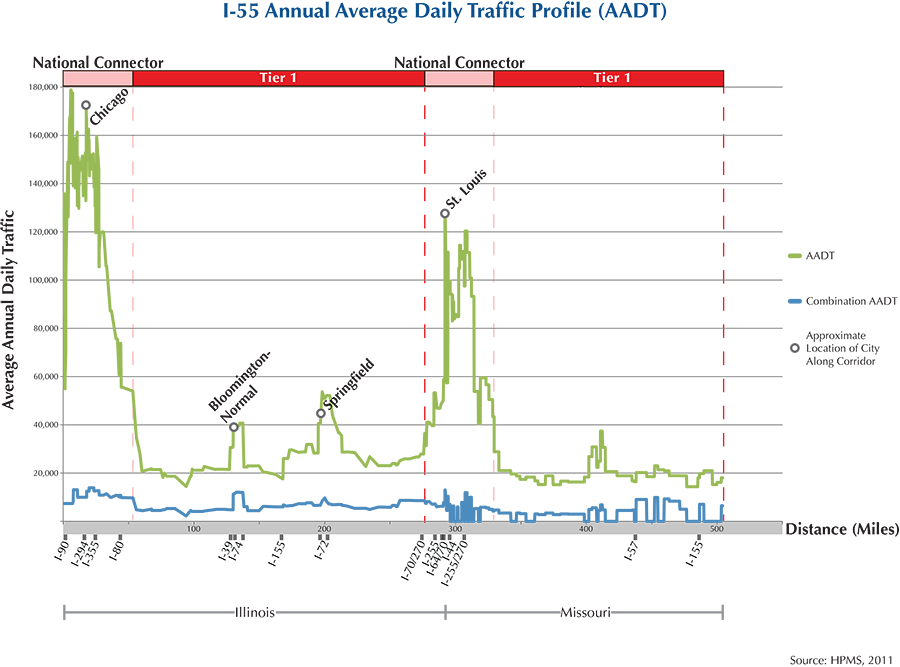
I-55 is not tolled in Missouri or Illinois. From north to south, I-55 begins in Chicago, and passes through Joliet, Pontiac, Bloomington, Lincoln, Springfield, Edwardsville, and Collinsville and into St Louis. The route continues south along the Mississippi River and passes through the communities of Cape Girardeau, Sikeston and into Arkansas at the southeast corner of Missouri.
Metropolitan Statistical Areas Economic Profile
| MSA | Population | GDP (2011, in millions) | Employment | Freight-related Employment | Metropolitan Planning Organizations |
| Chicago (IL) | 9,461,105 | $547,609 | 4,333,730 | 1,706,242 | Chicago Metropolitan Agency on Planning |
| Bloomington-Normal (IL) | 169,572 | $9,535 | 112,151 | 26,872 | McLean County Regional Planning Commission |
| Springfield (IL) | 210,170 | $9,917 | 138,352 | 30,314 | Springfield Area Transportation Study |
| St. Louis (MO-IL) | 2,787,701 | $132,029 | 1,338,018 | 502,178 | East-West Gateway Council of Governments |
| Cape Girardeau-Jackson (MO-IL) | 96,275 | $3,521 | 45,864 | 18,466 | Southeast MPO |
National Connectors
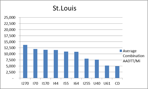
St. Louis
The interstates supporting freight originating in, destined for, and traveling through St. Louis are I-44, I-55, I-64, and I-70. In total, St. Louis has a total of 35 urban interstates, freeways, and expressways that support freight movements. I-70 and its national connectors I-270 and I-170 are the top three freight-carrying roadways ranked by average combination AADTT per mile. In total I-70, I-170, and I-270 carry 36.4 percent of truck miles traveled on urban interstates, freeways, and expressways within St. Louis.
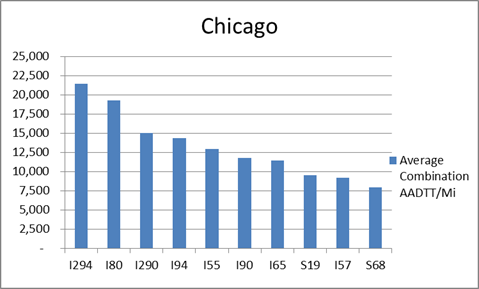
Chicago
The interstates supporting freight originating in, destined for, and traveling through Chicago include I-55, I-57, I-88, I-89, I-90, and I-94. In total, Chicago has 42 urban interstates, freeways, and expressways that support freight movements. Chicago’s geographic location as a crossroad of numerous interstates causes a dispersion of freight throughout a large network of national connectors and interstates that travel through the city. The average combination AADTT per mile on Chicago’s urban interstates, freeways, and expressways is over 10,000 trucks for seven roadways and nearly 20,000 combination trucks for two roadways.
Freight Projects Impacting Truck Traffic
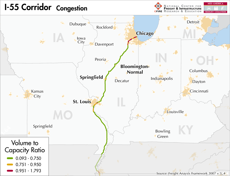
I-55 is an essential transportation corridor from Chicago to St. Louis and should see some major impacts from the development of the Illiana Corridor. This project is a new highway along a proposed alignment that will connect I-55 to I-65 to serve the burgeoning logistics centers developing in Will County, IL. This bi-state partnership between Indiana and Illinois seeks to relieve freight congestion on I-80 and I-94 by providing an alternative route outside of the Chicago metro area. This project will be developed with public-private financing.
Truck Traffic
I-55 is a 504-mile corridor that passes through two MAFC states: Missouri and Illinois.
- VMT 2007: 19,319,513
- Truck VMT 2007: 4,470,892
- Percent Truck VMT: 23.1 percent
Operational Efficiency (ITS)
There are 12 message boards and 30 cameras found along the I-55 corridor, all of which are found within the urban boundary of St. Louis.
Illinois collaborates with Indiana, Kentucky, and Ohio through ITS Midwest, whereas Missouri partners with Iowa, Kansas, Nebraska, and Oklahoma through ITS Heartland. Additionally, the Illinois DOT participates in the ENTERPRISE Pool Fund Study.
Greenhouse Gas Emissions
- Yearly tons of CO2 assuming 4 mpg: 2,800,000
- Yearly tons of CO2 assuming 7.5 mpg: 1,500,000
Methodology
- Data: Truck Counts (HPMS 2011)
- Assume 4 and 7.5 miles per gallon
- No control for level of service or elevation changes
- 22.3 lbs. of CO2 per gallon of diesel
Fuel and Truck Parking
| There are 42 fueling stops that also offer truck parking along I-55. Eight truck stops have less than 25 parking spots, 18 have between 25-84 spots, and 16 have 85+ parking spots. Compressed Natural Gas (CNG) and Liquified Natural Gas (LNG) stations are listed to the right. | I-55 | CNG | LNG |
| Public | 2 | 0 | |
| Private | 3 | 0 | |
| Planned | 0 | 1 | |
| Total | 5 | 1 |
Infrastructure Condition
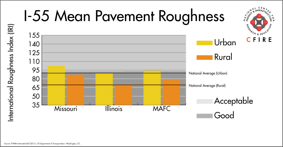
The International Roughness Index (IRI) measures the cumulative amount of vertical deviation (the bumpiness or roughness) for each segment of road, and is reported as a ratio in inches per mile. IRI values less than 95 are generally considered good, while values between 95 and 170 are generally considered acceptable. Since only corridor segments with reported IRI values from the 2011 HPMS dataset were considered in this analysis, some states may be missing from certain corridors.
The IRI is used as a measurement to determine infrastructure conditions within the Highway Performance Monitoring System (HPMS) such as pavement deterioration, pavement condition trends, cost allocation studies, and other analytical purposes. It is reported, at a minimum, for all road segments that fall under the Full Extent classification which includes the National Highway System (NHS), all principal arterials (interstates, freeways, and expressways), and rural minor arterials within the Sample Panel dataset. The data is collected by the states and submitted to the FHWA. The FHWA verifies the data, and houses it within the HPMS. For more historical information, see MnDOT’s Introduction to the International Roughness Index.
Freight Facilities
Intermodal terminals
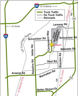
- BNSF Logistics Park Joliet, IL: TOFC-COFC
- BNSF Cicero, IL: TOFC-COFC (<40,000 lifts/yr.)
- BNSF Corwith, Chicago, IL: TOFC-COFC ( <80,000 lifts/yr.)
- BNSF Willow Springs, Hodgkins, IL: TOFC-COFC (<60,000 lifts/yr.)
- CSX Bedford Park, IL: TOFC-COFC
- CSX Rose Lake Yard East St. Louis: TOFC-COFC
- Norfolk Southern (NS) 47th Street Chicago: TOFC-COFC
- Union Pacific (UP) Global I Chicago: COFC (<40,000 lifts/yr.)
- Union Pacific (UP) Dupo, IL: TOFC-COFC) (<115,000 lifts/yr)
Major Rail Yards
- Missouri: 23rd Street Yard, Brooklyn, Tower Grove
- Illinois: Cicero Yard, Chicago 47th St. Yard, Corwith, East St. Louis, Illinois, Global I, Willow Springs Yard
Airports
- Chicago O’Hare International (ORD)
- Lambert-St. Louis International (STL)
Ports
- Port of Chicago
- Port of St. Louis
- Southeast Missouri Regional Port
- Hickman-Fulton County Riverport
Automotive Distribution Centers
- Joliet, IL – BNSF Logistics Park
- Normal, IL – Mitsubishi Motors: (Norfolk Southern)
- Centreville, IL – Union Pacific
Freight Rail
A portion of the I-55 corridor is a multimodal corridor. Commuter and Amtrak service share lines that move freight. Within Chicago, the 2010 freight density according to the 2013 National Transportation Atlas Database, is between 50 and 100 million gross tons (MGT) for the BNSF and CN lines For the remainder of the shared-use corridor along I-55 (Joliet to Springfield), Union Pacific Joliet Subdivision is very light, carrying less than five million gross tons per year. Reports that intermodal activity and projections of increased truck diversion may warrant a second track to separate future freight from passenger flows to St. Louis, MO. In Illinois, freight density over 20 MGT is considered a strategic transportation system. North and east of St. Louis, a number of high-density lines converge. Portions of the BNSF River Subdivision follow I-55 south of St. Louis with densities between 10-50 MGT.
Emerging Intermodal
Passenger Rail
A portion of the I-55 corridor is a multimodal corridor. Passenger rail service parallels I-55 from Joliet, IL. to Springfield, IL. There are two services between Chicago and St. Louis, Texas Eagle, which extends to San Antonio, and the Lincoln Service, which terminates in St. Louis. Train speeds of 110-mph were recently tested from Dwight to Pontiac Illinois, a 15-mile segment. Incremental upgrades to this route will allow higher speeds from Chicago to St. Louis.
Airports
There are two air cargo airports that service the I-55 corridor.
- STL, located in the St. Louis metro area, is the 14th ranked commercial airport in the MAFC region in terms of landed weight. Nationally, STL is ranked 61st. STL is considered a primary hub airport, and is serviced by both UPS and FedEx.
- SGF in Springfield, MO is the 18th ranked commercial airport in the MAFC region for landed weight, and is ranked 86th overall in the nation. It too is considered a primary hub airport, and is home to a UPS air cargo facility.
| Chicago O’Hare International (ORD) | Lambert-St. Louis International (STL) | |
| Cargo Facilities | Mechanical Handling, Heated Storage, Air-Conditioned Storage, Refrigerated Storage, Deep Freeze Storage, Mortuary, Animal Quarantine, Fresh Meat Inspection, Health Officials, X-Ray Equipment, Decompression Chamber, Security for Valuables, Dangerous Goods, Radioactive Goods, Very Large/Heavy Cargo, Express/Courier Centre Cargo; Handling Agents:Evergreen/EAGLE, Servisair/GlobeGround | Capacity 4 479 700tonnes (9 875 946,000lbs), 2x 747 Freighter Docks, Bonded Warehouse, Free Port/Foreign Trade Zone, Aircraft Maintenance, Mechanical Handling, Heated Storage, Air-Conditioned Storage, Refrigerated Storage, X-Ray Equipment, Security for Valuables, Dangerous Goods, Radioactive Goods, Very Large/Heavy Cargo, Express/Courier Centre, New cargo facility development by Aeroterm of 22854 sq metres also available |
| Cargo Terminals | 15 | 2 |
| Number of Runways (max length) | 5 (12,998 feet) | 4 (11,020 feet) |
| Warehouses & DCs within 5/10 miles | 27 / 56 | 15 / 41 |
| Air Cargo Businesses within Urban Area | 3,339 | 845 |
| 2011 Landed Weight (lbs.) | 4,368,420,500 | 384,332,870 |
| 2010 Landed Weight (lbs.) | 4,895,940,100 | 371,026,650 |
| Change (Percentage) | -10.77% | 3.59% |
| Intermodal Connectors (5/10 miles) | 7 / 28 | 2 / 7 |
Ports
M-55 is the designated Marine Highway reliever route for I-55. I-55 parallels M-55, which consists of the Illinois River and Mississippi River south to the Gulf of Mexico. The M-55 is the major central north-south axis of the US inland waterway system, connecting to the Great Lakes Navigation System at the Port of Chicago and the Gulf of Mexico at New Orleans, LA. Other major ports include St. Louis, MO; SE Missouri Port, MO; Elvis Stahr, KY; Memphis, TN; Greenville, MS; Vicksburg, MS; and Baton Rouge, LA. Numerous other smaller ports and terminals also provide access between these rivers and the interstate highway. M-55 also provides continuous water navigation to the rest of the navigable Mississippi River System which includes the Upper Mississippi River (M-94), Ohio River (eastern M-70), Missouri River (western M-70), and others.

Freight Generators, Warehouses, and Distribution Centers
There are a total of 27,957 freight generators employing 448,903 people within three miles of the I-55 corridor, and a total of 73,203 freight generators employing 1,055,980 people within 10 miles of the corridor. If the extent of analysis focuses on the metropolitan statistical areas (MSAs) intersected by the I-55 corridor, there are a total of 151,811 freight generators employing 2,284,072 people. Within the MSAs, there are a total of 520 warehousing and distribution centers employing 9,722 people. Freight generators were determined by using the NAICS codes prescribed for freight-related sectors in NCFRP Report 19, and include agriculture, mining, manufacturing, wholesale trade, retail trade, transportation and warehousing, and eating and drinking places.
Major Manufacturers |
Major Distribution Centers |
|
|
References
- Missouri Vehicle Route Map: 2012-2013. Missouri Department of Transportation.
- Illinois Designated Truck Route List. Illinois Department of Transportation.
- FHWA Interstate Brief (2011). US Department of Transportation.