DRAFT
Kansas City, Missouri to Pineville, Missouri
Snapshot: Length: 382 miles | Length in MAFC: 175 miles | Intersecting Interstates: I-10, I-20, I-30, I-35, I-44, I-70
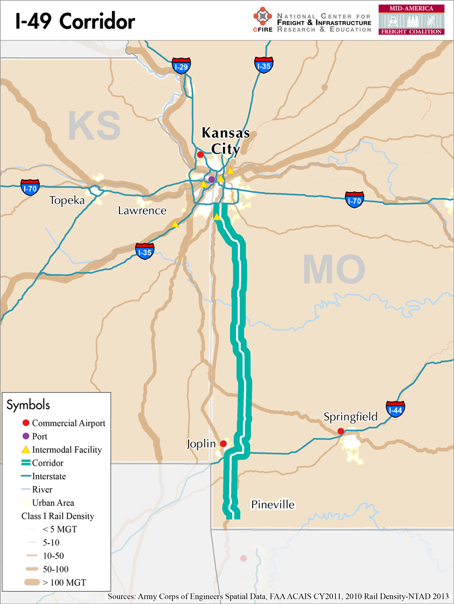
I-49 is an emerging north-south corridor in the state of Missouri. I-49 begins in Pineville, Missouri and runs 175 miles north to Kansas City, Missouri. While this segment appears specific to Missouri, a portion of I-49 also exists in Louisiana and plans are underway to complete the interstate designation in the state of Arkansas. Discussions among the State DOTs, including Missouri, Arkansas and Louisiana, are underway as of August 2013 as the agencies discuss the possibilities of completing the corridor to fulfill its planned border to border route, from the Gulf Coast to Winnipeg, Manitoba in Canada.
At the southern terminus of I-49 at I-10 in Lafayette, Louisiana, I-49 continues north towards Shreveport at its junction with I-20. I-49 continues north in Arkansas as I-540 and state highway 549. The corridor crosses briefly into Texas and then continues on north as US 71. At Pineville, Missouri the route transitions to I-49 and continues north to Kansas City Missouri where it intersects at Three Trails Crossing where it joins US 71 and I-435. The route then continues through Kansas City as the Bruce Watkins Freeway, a signalized section. Then this route connects to I-70, I-29 and I-35 offering both an east-west connection with I-70 and two north-south connections with I-35 and I-29.
This corridor provides service as an emerging corridor in the MAFC regional freight study network. This designation is based on the moderate truck traffic volumes along the corridor and its connections’ to major interstate freight corridors as well its proposed function as a border to border connection. As the connections and trade along this north-south corridor continue to grow it can be expected that I-49 will evolve to one of the more significant north-south corridors.
In the MAFC, I-49 is paralleled by rail service but not water. Further the northern BNSF intermodal development at Edgerton, KS and the east-west I70 connection suggest a robust future for I-49.
In Missouri, a Commercial Vehicle Restrictions/Closures Map is provided and I-49 is included in the state’s designated truck network. I-49 is not tolled on existing sections but toll financing has and is being discussed as a funding stream to complete section of the corridor in Arkansas.
In the MAFC, I-49 connects the communities of Joplin and Kansas City, Missouri. Ultimately, this emerging corridor is expected to play a role as a border-to-border trade corridor.
Metropolitan Statistical Areas Economic Profile
| MSA | Population | GDP (2011, in millions) | Employment | Freight-related Employment | Metropolitan Planning Organizations |
| Kansas City (MO-KS) | 2,009,342 | $108,144 | 1,036,081 | 398,896 | Mid-America Regional Council |
| Joplin (MO) | 175,518 | $5,979 | 92,778 | 41,835 | Joplin Area Transportation Study Organization |
National Connectors
There are no national connectors on the I-49 corridor in the MAFC region.
Freight Projects Impacting Truck Traffic
Between 2010 and 2012, Missouri completed a number of upgrades to the US 71 to achieve interstate highway standards. Once the Arkansas and Texas portions of the proposed I-49 corridor are completed and joined with the existing portion in Louisiana the region should see even greater benefits from I-49. In total, the I-29 and I-49 corridor links the Gulf Coast ports at New Orleans with Winnipeg, Canada .
Truck Traffic
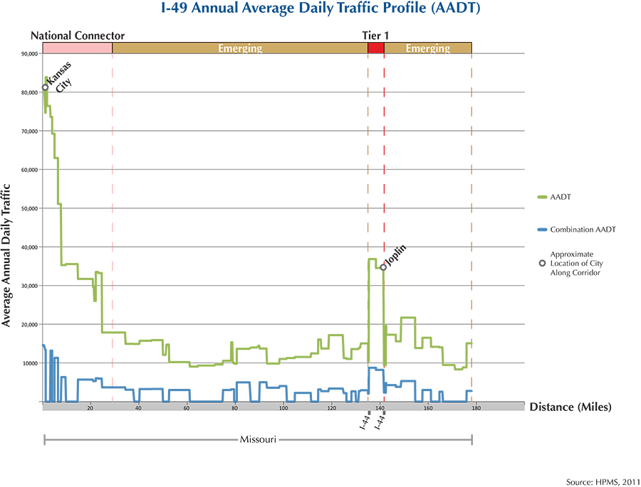
I-49 is a 175-mile corridor that crosses one state in the MAFC, Missouri.
- VMT 2007: 3,600,771
- Truck VMT 2007: 705,189
- Percent Truck VMT: 19.58 percent
Operational Efficiency (ITS)
There are four message boards along the I-49 corridor, three of which are located within the bounds of the urban area of Kansas City, and the last is found roughly 20 miles south of the city. The 15 cameras found on the corridor follow a very similar pattern, the majority (10) are found in Kansas City and the remaining 5 are found within 20 miles.
Missouri collaborates with Iowa, Kansas, Nebraska, and Oklahoma through ITS Heartland.
Greenhouse Gas Emissions
- Yearly tons of CO2 assuming 4 mpg: 510,000
- Yearly tons of CO2 assuming 7.5 mpg: 270,000
Methodology
- Data: Truck Counts (HPMS 2011)
- Assume 4 and 7.5 miles per gallon
- No control for level of service or elevation changes
- 22.3 lbs. of CO2 per gallon of diesel
Fuel and Truck Parking
| There are 7 fueling stops that also offer truck parking along I-49. Two truck stops have less than 25 parking stops, 2 have between 25-84 spots, and 3 have 85+ spots of parking capacity. Compressed Natural Gas (CNG) and Liquified Natural Gas (LNG) stations are listed to the right. | I-49 | CNG | LNG |
| Public | 0 | 0 | |
| Private | 1 | 0 | |
| Planned | 0 | 1 | |
| Total | 1 | 1 |
Infrastructure Condition
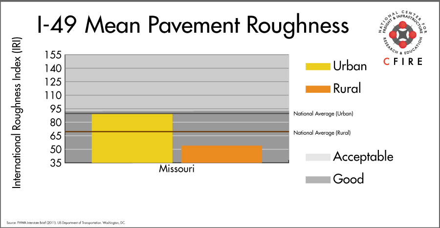
The International Roughness Index (IRI) measures the cumulative amount of vertical deviation (the bumpiness or roughness) for each segment of road, and is reported as a ratio in inches per mile. IRI values less than 95 are generally considered good, while values between 95 and 170 are generally considered acceptable. Since only corridor segments with reported IRI values from the 2011 HPMS dataset were considered in this analysis, some states may be missing from certain corridors.
The IRI is used as a measurement to determine infrastructure conditions within the Highway Performance Monitoring System (HPMS) such as pavement deterioration, pavement condition trends, cost allocation studies, and other analytical purposes. It is reported, at a minimum, for all road segments that fall under the Full Extent classification which includes the National Highway System (NHS), all principal arterials (interstates, freeways, and expressways), and rural minor arterials within the Sample Panel dataset. The data is collected by the states and submitted to the FHWA. The FHWA verifies the data, and houses it within the HPMS. For more historical information, see MnDOT’s Introduction to the International Roughness Index.
Freight Facilities
Intermodal Terminals
- Kansas City Southern (KCS) International Freight Gateway, Kansas City, MO: TOFC-COFC (70,000-lift/yr. capacity)
Major Rail Yards
None.
Airports
- Kansas City, Missouri (MCI)
Ports
None.
Automotive Distribution Facilities
- Mazda USA
Freight Rail
There are a few rail lines that cross the northern part of this corridor in Kansas City: the Kansas City Southern (KCS) Pittsburg Subdivision and the Union Pacific Coffeyville Subdivision. Further south, near Lamar, the BNSF Scott Subdivision crosses the corridor. In Joplin, the KCS Heavener Subdivision enters the corridor and heads south. These lines, according to 2010 rail density data available from the 2013 National Transportation Atlas Database are medium-density carrying between 50-100 million gross tons (MGT) per year. This corridor sits at the junction of BNSF’s MidCon and TransCon Corridors and KCS’ corridor to Mexico and its ports.
Emerging Intermodal
Mexico has made considerable investments in its Port of Lázaro Cardenas and in new automotive factories. KCS’ subsidiary, Kansas City Southern de México has direct links to the booming manufacturing industry. KCS also has trackage rights to many of the automotive terminals in the Midwest.
Passenger Rail
There is no passenger rail service that runs through the I-49 corridor.
Airports
There is one air cargo airport along the I-49 corridor.
MCI in Kansas City is ranked 11th within the MAFC region and 50th nationally in terms of landed weight in 2012. MCI is considered a primary hub airport, and is serviced by both UPS and FedEx air cargo facilities.
| Kansas City International (MCI) | |
| Cargo Facilities | Warehouse 30 000m² (322 917sq ft), Bonded Warehouse, Transit Zone, Free Port/Foreign Trade Zone, Aircraft Maintenance, Mechanical Handling, Heated Storage, Air-Conditioned Storage, Refrigerated Storage, Animal Quarantine, Fresh Meat Inspection, Health Officials, X-Ray Equipment, Security for Valuables, Dangerous Goods, Radioactive Goods, Very Large/Heavy Cargo, Express/Courier Centre, Handling Equipment: Airport owned CAS Wide-body Main Deck Loader for lezse per use |
| Cargo Terminals | 5 |
| Number of Runways (max. length) | 3 (10,800 feet) |
| Warehouses & DCs within 5/10 miles | 1 / 2 |
| Air Cargo Businesses within Urban Area | 626 |
| 2011 Landed Weight (lbs.) | 423,890,310 |
| 2010 Landed Weight (lbs.) | 431,918,705 |
| Change (Percentage) | -1.86% |
| Intermodal Connectors (5/10 miles) | 4 / 4 |
Ports
M-49 is the designated Marine Highway reliever route for I-49. However, M-49 only extends as far north as Shreveport, LA, and does not intersect nor run parallel to the northern portion of I-49 within the MAFC region. M-40, which serves as a Marine Highway Connector, is located to the south of Missouri’s portion of I-49. It can be accessed as far west as Port Catoosa, OK or south of Missouri at Fort Smith, AR, and connects to the M-55 Corridor at Napoleon, AR. Another option for shippers located along I-49 wishing to utilize the marine highways would be to access the M-70 Corridor (which intersects M-55 in St. Louis) at ports in Kansas City.


Freight Generators, Warehouses, and Distribution Centers
There are a total of 2,441 freight generators employing 39,569 people within three miles of the I-49 corridor, and a total of 7,437 freight generators employing 117,281 people within 10 miles of the corridor. If the extent of analysis focuses on the metropolitan statistical areas (MSAs) intersected by the I-49 corridor, there are a total of 26,021 freight generators employing 440,731 people. Within the MSAs, there are a total of 128 warehousing and distribution centers employing 3,991 people. Freight generators were determined by using the NAICS codes prescribed for freight-related sectors in NCFRP Report 19, and include agriculture, mining, manufacturing, wholesale trade, retail trade, transportation and warehousing, and eating and drinking places.
References
- Interstate 49. Wikipedia.
- Saylor, Ryan (2013). Officials from three states gather to talk I-49 funding. The City Wire.
- Maximizing Transportation Efficiencies and Economic Impact of the Southwest Missouri Foreign Trade Zone. Missouri Department of Transportation.
- Missouri Vehicle Route Map: 2012-2013. Missouri Department of Transportation.
- FHWA Interstate Brief (2011). US Department of Transportation.